
Ptolemy, Claudius

Claudius Ptolemy (83 - 161 AD) is considered to be the father of cartography. A native of Alexandria living at the height of the Roman Empire, Ptolemy was renowned as a student of Astronomy and Geography. His work as an astronomer, as published in his Almagest, held considerable influence over western thought until Isaac Newton. His cartographic influence remains to this day. Ptolemy was the first to introduce projection techniques and to publish an atlas, the Geographiae. Ptolemy based his geographical and historical information on the "Geographiae" of Strabo, the cartographic materials assembled by Marinus of Tyre, and contemporary accounts provided by the many traders and navigators passing through Alexandria. Ptolemy's Geographiae was a groundbreaking achievement far in advance of any known pre-existent cartography, not for any accuracy in its data, but in his method. His projection of a conic portion of the globe on a grid, and his meticulous tabulation of the known cities and geographical features of his world, allowed scholars for the first time to produce a mathematical model of the world's surface. In this, Ptolemy's work provided the foundation for all mapmaking to follow. His errors in the estimation of the size of the globe (more than twenty percent too small) resulted in Columbus's fateful expedition to India in 1492.
Ptolemy's text was lost to Western Europe in the middle ages, but survived in the Arab world and was passed along to the Greek world. Although the original text almost certainly did not include maps, the instructions contained in the text of Ptolemy's Geographiae allowed the execution of such maps. When vellum and paper books became available, manuscript examples of Ptolemy began to include maps. The earliest known manuscript Geographias survive from the fourteenth century; of Ptolemies that have come down to us today are based upon the manuscript editions produced in the mid 15th century by Donnus Nicolaus Germanus, who provided the basis for all but one of the printed fifteenth century editions of the work.
Ptolemy's text was lost to Western Europe in the middle ages, but survived in the Arab world and was passed along to the Greek world. Although the original text almost certainly did not include maps, the instructions contained in the text of Ptolemy's Geographiae allowed the execution of such maps. When vellum and paper books became available, manuscript examples of Ptolemy began to include maps. The earliest known manuscript Geographias survive from the fourteenth century; of Ptolemies that have come down to us today are based upon the manuscript editions produced in the mid 15th century by Donnus Nicolaus Germanus, who provided the basis for all but one of the printed fifteenth century editions of the work.
Roman-Era Egypt, as drafted by a Native Son.
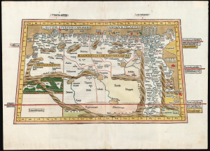
Tercia Affrice Tabula.
$11,000.00
Acquire
- Digital Map Information
- Suitable for large format printing
- Full resolution TIFF file
- ICC color profile embedded
- Delivered instantly via download link
This is a superb example, in rich original color, of one of the earliest printed maps of any part of Africa - this one focusing on the region of Libya and Egypt extending to the Red Sea, according to the second-century knowledge of Claudius Ptolemy. It appeared in the Ulm Ptolemy, the first such work printed north of the Alps, in 1482 and 1486. It is the first map of the region by someone who lived there. (more details)
Eastern reaches of the Silk Road.
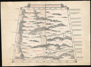
Octava Asia Tabula.
$2,000.00
Acquire
- Digital Map Information
- Suitable for large format printing
- File Size: 18.22 MB
- File Type: ZIP / TIFF
- ICC color profile embedded
- Delivered instantly via download link
This is a rare example of Bernard Sylvanus' 1511 Ptolemaic map of the eastern reaches of the Silk Road. Printed in a single edition, it is one of the most visually distinctive early woodcut maps to detail parts of modern-day Kazakhstan, Kyrgyzstan, and Tajikistan, the northeastern part of Mongolia, and the Xinjiang province of China. For Ancient Romans, this was the most remote part of the known world: Serica, named after the precious silk understood to originate there. (more details)
One of the Earliest Printed Maps of India.
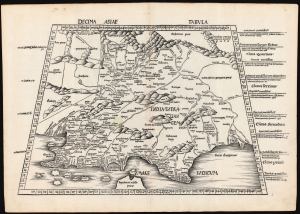
Decima Asie Tabula.
$8,500.00
Acquire
- Digital Map Information
- Suitable for large format printing
- File Size: 22.27 MB
- File Type: ZIP / TIFF
- ICC color profile embedded
- Delivered instantly via download link
This is Martin Waldseemüller's 1513 edition of the Ptolemaic map of India, one of the earliest acquirable maps of the area and an essential step in the subcontinent's cartographic evolution. Waldseemüller and Ringmann issued it for their 1513 Geographie Opus Novissima, the most comprehensively edited and amended edition of Claudius Ptolemy's 2nd-century geography. Moreover, this map was the largest format edition of Ptolemy's map to have been produced to date. (more details)
Anatolia as known to Ancient Rome.
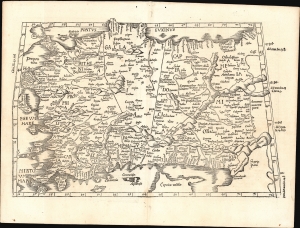
[Tabula I. Asiae].
$1,000.00
Acquire
- Digital Map Information
- Suitable for large format printing
- Full resolution TIFF file
- ICC color profile embedded
- Delivered instantly via download link
This is Laurent Fries' 1525 edition of Martin Waldseemüller's Ptolemaic map of Anatolia, one of the earliest generally acquirable maps of what would become modern-day Turkey. (more details)
One of the Earliest Modern Maps Ceylon / Sri Lanka.
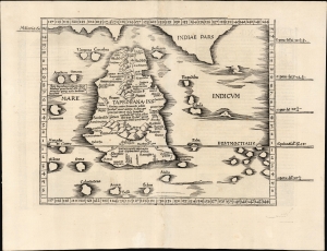
[Tabula XII. Asiae.]
$750.00
Acquire
- Digital Map Information
- Suitable for large format printing
- Full resolution TIFF file
- ICC color profile embedded
- Delivered instantly via download link
This is Laurent Fries' 1525 edition of Martin Waldseemüller's Ptolemaic map of Sri Lanka. This island - here named Taprobana - represented, for Ptolemy, the limit of European geographic knowledge in the east. The smallest area to have appeared in Ptolemaic canon, later geographers wrestled with the identity of the island depicted. Many correctly identified the island as Sri Lanka, though Munster, Mercator, and others speculated that the better candidate was Sumatra. (more details)
Foundation of the mapping of Arabia.
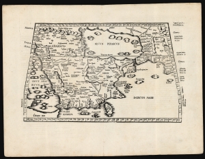
[Tabula Sexta Asiae].
$2,750.00
Acquire
- Digital Map Information
- Suitable for large format printing
- Full resolution TIFF file
- ICC color profile embedded
- Delivered instantly via download link
This is Laurent (Lorenz) Fries' 1522 map of Arabia, among the earliest acquirable maps of the Arabian Peninsula. Although presenting 2nd-century Ptolemaic geography, this map remained accurate and relevant and one of the best maps of the peninsula available. (more details)
Foundational Work in the History of the Atlas.
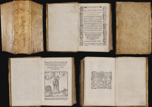
La Geografia, con alcuni comenti e aggiunte fattevi da Sebastiano Munstero, con le tavole non solamente antiche and moderne solite di sta(m)parsi, ma altre nuovo aggiuntevi di Jacopo Gastaldo, ridotta in volgare Italiano da Pietro Andrea Mattiolo.
$42,500.00
Acquire
This is Giacomo Gastaldi's 1548 La Geografia , the first iteration of Ptolemy's foundational ur-atlas to be published in a vernacular. It is the most important proto-atlas to be produced between Martin Waldseemüller's 1513 Ptolemy and Ortelius' 1570 Theatrum. Nordenskiöld hailed it 'the very first atlas of the New World,' citing the work's groundbreaking inclusion of separate maps of the Americas. The work bridges two pillars of Renaissance European geography: the Italian Gastaldi and the German Sebastian Münster. (more details)
Rome's Provinces in Northwest Africa.
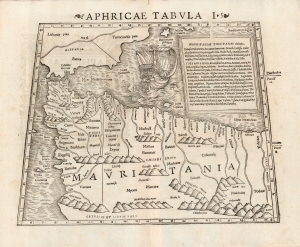
Aphricae Tabula I.
$750.00
Acquire
- Digital Map Information
- Suitable for large format printing
- DPI: 600
- File Size: 22.61 MB
- File Type: ZIP / TIFF
- ICC color profile embedded
- Delivered instantly via download link
This is a beautiful 1552 example of Sebastian Münster's Ptolemaic map of northwestern Africa and the Strait of Gibraltar. This was the first of Ptolemy's three particular maps of the part of Africa known to Rome in the second century; it represented the southwestern limit of the Alexandrian Roman geographer's knowledge.
Specifically, the map focuses on the Roman African provinces (annexed by Emperor Claudius in 44 C.E.) of Mauretania Tingitana west of the Moulouya River, and Mauritania Caesariensis to the east of it. The two provinces were administered respectively from the coastal cities of Tangier (Tingis) and Jol Caesarea (now called Cherchell, in modern Algeria.) Both of these are shown and named on the map. The map extends southwards to the Atlas Mountains, which Rome considered to be the southern border of their African provinces. (Rome's actual occupation did not reach so far - in the west, the area of Volubilis (here 'Voli Bilian')The The eastern limit of the map is the River Ampsaga, which represented the boundary between Mauretania and Numidia. it is now understood to correspond with the modern Oued-el-kabir river in Algeria. Thus, the present map extends through most of Algeria and Morocco. (more details)
Specifically, the map focuses on the Roman African provinces (annexed by Emperor Claudius in 44 C.E.) of Mauretania Tingitana west of the Moulouya River, and Mauritania Caesariensis to the east of it. The two provinces were administered respectively from the coastal cities of Tangier (Tingis) and Jol Caesarea (now called Cherchell, in modern Algeria.) Both of these are shown and named on the map. The map extends southwards to the Atlas Mountains, which Rome considered to be the southern border of their African provinces. (Rome's actual occupation did not reach so far - in the west, the area of Volubilis (here 'Voli Bilian')The The eastern limit of the map is the River Ampsaga, which represented the boundary between Mauretania and Numidia. it is now understood to correspond with the modern Oued-el-kabir river in Algeria. Thus, the present map extends through most of Algeria and Morocco. (more details)
Roman-Era Egypt, as drafted by a Native Son.
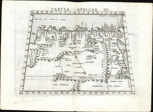
Tabula Africae III.
$600.00
Acquire
- Digital Map Information
- Suitable for large format printing
- Full resolution TIFF file
- ICC color profile embedded
- Delivered instantly via download link
This is a handsome example, in its first edition, of Girolamo Ruscelli's 1561 map of Libya and Egypt, extending to the Red Sea, based on the 2nd-century knowledge of Claudius Ptolemy. It represents the first mapping of the region based on information from someone who lived there. (more details)
Northeastern Europe as Known to the Ancients.
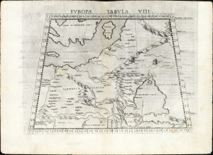
Europa Tabula VIII.
$350.00
Acquire
- Digital Map Information
- Suitable for large format printing
- Full resolution TIFF file
- ICC color profile embedded
- Delivered instantly via download link
This is the 1561 first Ruscelli edition of Ptolemy's map of the lands in Europe occupied in the 1st and 2nd centuries CE by the Sarmatians, a large Iranian confederation who, during the classical era, were pressing from the steppes north of the Black Sea into what would become Russia, Ukraine, Poland, and Hungary. (more details)
Magini's First Latin Edition.
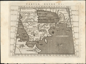
Tabula Asiae VI.
$650.00
Acquire
- Digital Map Information
- Suitable for large format printing
- Full resolution TIFF file
- ICC color profile embedded
- Delivered instantly via download link
This is Giovanni Antonio Magini's Ptolemaic map of Arabia, appearing in his first 1596 edition of Ptolemy's Geographia. This new translation, engraved by Girolamo Porro, was the most attractively executed small-format edition of the ancient geographic text. (more details)
Africa and Anatolia as Known to the Ancients.
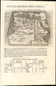
Tavola Quarta Dell' Africa./ Tavola Prima Dell'Asia.
$250.00
Acquire
- Digital Map Information
- Suitable for large format printing
- Full resolution TIFF file
- ICC color profile embedded
- Delivered instantly via download link
This is Giovanni Antonio Magini's Ptolemaic map of Africa, from the 1598 first Italian edition of Ptolemy's Geographia. The maps, engraved by Girolamo Porro, graced the most attractively executed small-format edition of the classical geographic text. The verso contains Magini's Ptolemaic map of Asia Minor. (more details)
The Most Distant island Mapped in Ptolemy's Era
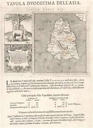
Tavola Duodecima Dell'Asia
$400.00
Acquire
- Digital Map Information
- Suitable for large format printing
- DPI: 600
- File Size: 4.52 MB
- File Type: ZIP / TIFF
- ICC color profile embedded
- Delivered instantly via download link
This is Giovanni Antonio Magini's map of Taprobana, appearing in his 1598 Italian edition of Ptolemy's Geographia. This island represented, for Ptolemy, nearly the limit of European geographic knowledge: later geographers typically identified the island as Sri Lanka, though Munster, Mercator and others speculated that the better candidate was Sumatra. The map is oriented to the north and includes not only ‘Taprobana’ but also twenty surrounding islands. The mainland appears above and on the right of the map, which would correspond to the Malay peninsula were the map correctly identified with Sumatra, although the map roughly adheres to Sri Lanka's teardrop shape. To the left of the map is an attractively-engraved illustration of an elephant, and eleven lines of text describing the pepper trade - explicitly identifying the island as Sumatra. Magini joins Gastaldi, and Ruscelli in following the model of Münster, whose version of this map in his own edition of Ptolemy contained these same elements.
Magini's Italian letterpress text below the engraved map describes the island, its people, and its produce. (more details)
Magini's Italian letterpress text below the engraved map describes the island, its people, and its produce. (more details)