
1548 Giacomo Gastaldi / Claudius Ptolemy: 1st vernacular geography, sole edition

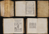
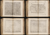
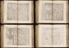
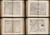
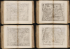
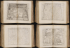
La Geografia, con alcuni comenti e aggiunte fattevi da Sebastiano Munstero, con le tavole non solamente antiche and moderne solite di sta(m)parsi, ma altre nuovo aggiuntevi di Jacopo Gastaldo, ridotta in volgare Italiano da Pietro Andrea Mattiolo.
Foundational Work in the History of the Atlas.
Foundational Work in the History of the Atlas.
This is Giacomo Gastaldi's 1548 La Geografia , the first iteration of Ptolemy's foundational ur-atlas to be published in a vernacular. It is the most important proto-atlas to be produced between Martin Waldseemüller's 1513 Ptolemy and Ortelius' 1570 Theatrum. Nordenskiöld hailed it 'the very first atlas of the New World,' citing the work's groundbreaking inclusion of separate maps of the Americas. The work bridges two pillars of Renaissance European geography: the Italian Gastaldi and the German Sebastian Münster.A Closer Look
Following the publisher's dedications and notes to the reader, this neat, vellum-bound octavo opens with Münster's most visible contribution: an argument for the importance of geography as a discipline'Geography is a science that teaches the description of the Earth and reveals the location of the entire world; this knowledge is so essential to scholars that no one, in any field of study, can make successful progress without it…'The first half of the book that follows is the Italian translation of Ptolemy's 2nd century work. The maps follow. Gastaldi's organization of the maps differs from any earlier Ptolemy. Before 1513, printed Ptolemies contained only a few contemporary maps, or tabulae modernae; Waldeemüller's 1513 and Münster's 1540 editions included a comparatively small number of tabulae modernae, and presented them separately from the Ptolemaic maps. Gastaldi instead interspersed the 26 ancient maps with their modern counterparts, so that, for example, Tabula Europae I is immediately followed by the corresponding modern map of the British Isles. This arrangement facilitated the quick comparison of ancient with modern geography. The Ptolemaic map of Eastern Europe (Tabula Europae VIII) is accompanied by two modern maps, Prussia E Livonia Nova and Schonlandia Nova; Ptolemy's map of Libya and the Lower Nile is accompanied by not only the modern map of that region, but with the first modern map of the Nile River Delta, Egyptus Nova Tabula.
Gastaldi continues where Ptolemy left off: this book contains some of the first detailed maps of the lands of the Western Hemisphere. The assemblage of maps ends with two modern maps of the world: Gastaldi's Universale Novo, and his distinctive Carta Marina. Many of the maps, particularly the Ptolemaic ones, are embellished with abundant decorative engraving - Tabula Asiae III, for instance, presenting the Ancient Caucasus, is replete with birds, a lifelike camel, an inexplicable monkey, and (floating in the Caspian) Noah's Ark. Monsters, beasts, and ships make appearances throughout.
A Groundbreaking Humanist Ptolemy
Gastaldi's work is the first translation of Ptolemy into a vernacular language (Italian) by the Sienese doctor and naturalist Pietro Andrea Mattioli (1501 - 1578). The book thus sits among the earliest geographical works presented to a literate, lay audience: the vanguard of humanist, early modern scholarship. The production of such works depended on a broad, uncloistered readership's ability to engage with and comprehend complicated ideas.Not only was the language of this Ptolemy intended to be accessible; the format of the work was chosen for that end. It was the first such small-format proto-atlas to see print. In the opening text, Pedrezano praises Gastaldi in
'having all the plates engraved on copper with exquisite craftsmanship and reducing everything to such a compact size that anyone can conveniently carry it in their sleeve - an achievement truly worthy of every favor and infinite praise.'This was both revolutionary and a rebirth. While copperplate folio editions of Ptolemy had been printed in the 15th and early 16th centuries, the intervening years saw only woodcuts: a medium ill-suited to producing the small, detailed octavo maps. By utilizing copper engraving, Gastaldi made the small format possible for the first time. The volume would not necessarily have been inexpensive - the publisher never made that claim - but its portability meant that it could travel more easily than an ungainly folio, and thus reach more readers.
The work's place in 16th-century humanism is underscored by its collaboration with the German geographer Sebastian Münster. Münster not only provided the source for the Ptolemaic maps and many of the tabulae modernae, but also contributed an addendum arguing for the importance and relevance of geography as a science, and the value of its study to all people.
The inclusion of Münster in this volume later became problematic for Catholics. An outspoken Protestant, Münster was added to the Vatican's index of forbidden authors in 1559, seven years after his death. While his name and his addendum were not censored within the text, Münster's name is partially erased from the title page of this example, no doubt to evade the scrutiny of the casual eye.
State of the Art Geography
While anchored in classical maps derived from the 2nd-century Roman ur-geographer Claudius Ptolemy, Gastaldi's tabulae moderni are notable for showing up-to-date topography of those areas, and for expanding coverage beyond the limits of classical geographical knowledge. Among the maps of the Americas are the first separate map of the North American eastern seaboard, the first map to detail what would be the southern United States and Mexico, the first map to focus specifically on South America; and the earliest detailed maps of Cuba and Hispaniola. The map of Prussia and Livonia is likewise the first modern map of that region based on contemporary knowledge. The map of India - Calecut Nova Tavola - is the first separate map of the Indian Peninsula based on modern exploration.The Enduring Relevance of Ptolemy
European exploration in the late 15th and early 16th centuries expanded the known world far beyond Claudius Ptolemy's 2nd-century geographical knowledge. And yet, mapmakers continued to publish editions of Ptolemy - as here, in company with modern maps reflecting discoveries. Two reasons explain this: First, Ptolemy's geography was among the only available references to locations from antiquity, shedding light on humanistic attempts to recover and understand ancient literature. Second, Ptolemy's methodology remained essential and authoritative. By employing his great innovation - laying out a grid and assigning coordinates to real-world locations - one could produce a mathematical representation of the world, clearly showing the distances between known features. Every geographer of the Age of Discovery embraced Ptolemy's methodologies to absorb discoveries. Any geographer needed to understand the Ptolemaic foundations of their discipline before undertaking any new work. Consequently, editions of Ptolemy would continue to be printed well into the 18th century. Manuscript and print editions of Ptolemy were produced during the 15th and 16th centuries.Publication History and Census
This edition of Ptolemy was published in a single Pedrezano edition in Venice in 1548. It is well represented in institutional collections, with 51 examples in OCLC.Cartographers
Giacomo Gastaldi (c. 1500 - October, 1566) was an Italian astronomer, cartographer, and engineer active in the second half of the 16th century. Gastaldi (sometimes referred to as Jacopo or Iacobo) began his career as an engineer, serving the Venetian Republic in that capacity until the fourth decade of the sixteenth century. During this time he traveled extensively, building a large library relating to voyages and exploration. From about 1544 he turned his attention to mapmaking, working extensively with Gextantiovanni Battista Ramusio, Nicolo Bascarini, and Giovanbattista Pedrezano, as well as taking private commissions for, among others, Venice's Council of Ten. He is credited with the fresco maps of Asia and Africa still extant in the map room of the Doge's Palace. Gastaldi was also one of the first cartographers to embrace copper plate over woodblock engraving, marking an important development in the history of cartography. His 1548 edition of Ptolemy's Geographia was the first to be printed in a vernacular; it was the first to be printed in copperplate. As with his Swiss/German contemporary Münster, Gastaldi's work contained many maps depicting newly discovered regions for the first time, including the first map to focus on the East Coast of North America, and the first modern map of the Indian Peninsula. His works provided the source for the vast majority of the Venetian and Roman map publishers of the 1560s and 70s, and would continue to provide an outsize influence on the early maps of Ortelius, De Jode, and Mercator. Further Details...
Claudius Ptolemy (83 - 161 AD) is considered to be the father of cartography. A native of Alexandria living at the height of the Roman Empire, Ptolemy was renowned as a student of Astronomy and Geography. His work as an astronomer, as published in his Almagest, held considerable influence over western thought until Isaac Newton. His cartographic influence remains to this day. Ptolemy was the first to introduce projection techniques and to publish an atlas, the Geographiae. Ptolemy based his geographical and historical information on the "Geographiae" of Strabo, the cartographic materials assembled by Marinus of Tyre, and contemporary accounts provided by the many traders and navigators passing through Alexandria. Ptolemy's Geographiae was a groundbreaking achievement far in advance of any known pre-existent cartography, not for any accuracy in its data, but in his method. His projection of a conic portion of the globe on a grid, and his meticulous tabulation of the known cities and geographical features of his world, allowed scholars for the first time to produce a mathematical model of the world's surface. In this, Ptolemy's work provided the foundation for all mapmaking to follow. His errors in the estimation of the size of the globe (more than twenty percent too small) resulted in Columbus's fateful expedition to India in 1492.
Ptolemy's text was lost to Western Europe in the middle ages, but survived in the Arab world and was passed along to the Greek world. Although the original text almost certainly did not include maps, the instructions contained in the text of Ptolemy's Geographiae allowed the execution of such maps. When vellum and paper books became available, manuscript examples of Ptolemy began to include maps. The earliest known manuscript Geographias survive from the fourteenth century; of Ptolemies that have come down to us today are based upon the manuscript editions produced in the mid 15th century by Donnus Nicolaus Germanus, who provided the basis for all but one of the printed fifteenth century editions of the work.
Further Details...
Sebastian Münster (January 20, 1488 - May 26, 1552), was a German cartographer, cosmographer, Hebrew scholar and humanist. He was born at Ingelheim near Mainz, the son of Andreas Munster. He completed his studies at the Eberhard-Karls-Universität Tübingen in 1518, after which he was appointed to the University of Basel in 1527. As Professor of Hebrew, he edited the Hebrew Bible, accompanied by a Latin translation. In 1540 he published a Latin edition of Ptolemy's Geographia, which presented the ancient cartographer's 2nd century geographical data supplemented systematically with maps of the modern world. This was followed by what can be considered his principal work, the Cosmographia. First issued in 1544, this was the earliest German description of the modern world. It would become the go-to book for any literate layperson who wished to know about anywhere that was further than a day's journey from home. In preparation for his work on Cosmographia, Münster reached out to humanists around Europe and especially within the Holy Roman Empire, enlisting colleagues to provide him with up-to-date maps and views of their countries and cities, with the result that the book contains a disproportionate number of maps providing the first modern depictions of the areas they depict. Münster, as a religious man, was not producing a travel guide. Just as his work in ancient languages was intended to provide his students with as direct a connection as possible to scriptural revelation, his object in producing Cosmographia was to provide the reader with a description of all of creation: a further means of gaining revelation. The book, unsurprisingly, proved popular and was reissued in numerous editions and languages including Latin, French, Italian, and Czech. The last German edition was published in 1628, long after Münster's death of the plague in 1552. Cosmographia was one of the most successful and popular books of the 16th century, passing through 24 editions between 1544 and 1628. This success was due in part to its fascinating woodcuts (some by Hans Holbein the Younger, Urs Graf, Hans Rudolph Manuel Deutsch, and David Kandel). Münster's work was highly influential in reviving classical geography in 16th century Europe, and providing the intellectual foundations for the production of later compilations of cartographic work, such as Ortelius' Theatrum Orbis Terrarum Münster's output includes a small format 1536 map of Europe; the 1532 Grynaeus map of the world is also attributed to him. His non-geographical output includes Dictionarium trilingue in Latin, Greek, and Hebrew, and his 1537 Hebrew Gospel of Matthew. Most of Munster's work was published by his stepson, Heinrich Petri (Henricus Petrus), and his son Sebastian Henric Petri. Further Details...
Condition
Very good. 8vo. [7 x 4.5 inches], (8), 214 ff., including woodcut title 8 woodcuts in text, (2) ff., 184 ff., including 60 double-page engraved maps. Bound in contemporary soft vellum, resewn, with title inked on spine. Early inscriptions on front leaf. Neatly abraded text on title page (Sebastiano Munstero); old manuscript completion of 'Tabula Africae I'; few instances of soft strikes and printers' creases on maps, overall maps good, strikes ranging from good to excellent.
References
OCLC 3455904. Rumsey 11479. Bifolco, S., and Ronca, F., Cartografia e Topografia Italiana del XVI Secolo, Appendix F. Adams, H. M., Catalogue of Books Printed on the Continent of Europe, 1501-1600 in Cambridge Libraries, #P-2234. Mortimer, R., Harvard College Library Department of Printing and Graphic Arts. Catalogue of Books and Manuscripts. Part II: Italian 16th Century Books, #404. Harrisse, H., Bibliotheca Americana Vetusissima, #285. Parke-Bernet Galleries, The Celebrated Collection of Americana Formed by the Late Thomas Winthrop Streeter, #I.17. Phillips, P. L., A List of Geographical Atlases in the Library of Congress, 6140.369. Nordenskiöld, A.E., Facsimile-atlas to the early history of cartography with reproductions of the most important maps printed in the XV and XVI centuries, #28. Karrow, R., Mapmakers of the Sixteenth Century and Their Maps, pp. 220ff. Burden, P., The Mapping of North America, #16, 17. Shirley, Rodney W., The Mapping of the World: Early Printed World Maps 1472-1700, #87, 88, cf. 85. Gole, S., India Within the Ganges, p. 47.