
Rauschenfels-Steinberg, Jakob von (sold)

Jakob von Rauschenfels-Steinberg (1779 - August 21, 1841) was an artist, engraver, and lithographer based in Vienna. He was a specialist in depictions of grand buildings, especially churches and cathedrals, and cityscapes. He was among a group of Viennese engravers who contributed to the ten-volume travelogue Das malerische und romantische Deutschland, published between 1837 and 1850, which helped to strengthen German national identity.
First Edition, First State of a later censured Map of Hungary.
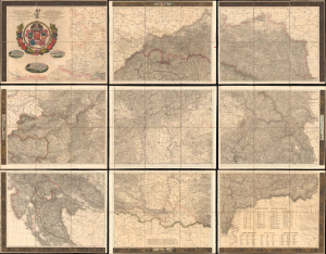
Magyar Ország, Horvát, Tót, Dalmát, és Erdély Országok, a tenger mellék és a végőri videkék kőzonséges pśták és útak főldabrosza... / Vollstaendige General Posten- und Strassen-Karte des Königreichs Ungran, der Königreiche Croatien, Slavonien, Dalmatien, des Grossfürstenth. Siebenbürgen, des Küstenlandes und der Militair-Grenze...
sold
- Digital Map Information
- Suitable for large format printing
- File Size: 591.44 MB
- File Type: ZIP / TIFF
- ICC color profile embedded
- Delivered instantly via download link
This is Blaschnék Sámuel and Schedius Lajos' lavish, very large-format bilingual (Hungarian-German) c. 1836 folding map of the Kingdom of Hungary, here in its first-edition first-state. It depicts the kingdom in the wake of the Napoleonic Wars, when it was in the midst of a reform movement, and represents the most detailed and up-to-date mapping of the kingdom in the first half of the 19th century. (more details)