
Romer, Jack (sold)

Jack Romer (1898 - April 28, 1967) was a staff artist for the New York Daily News who produced maps and charts for publication in the newspaper. Romer began working for the New York Daily News around 1932 and worked there until his death.
Highlights Germany's desire to regain its African colonies - and depicts the Anschluss, Germany's annexation of Austria.
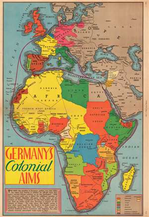
Germany's Colonial Aims.
sold
- Digital Map Information
- Suitable for large format printing
- File Size: 27.91 MB
- File Type: ZIP / TIFF
- ICC color profile embedded
- Delivered instantly via download link
This is a 1938 Jack Romer map of Africa highlighting various world power's colonial possessions throughout the continent only a year before the outbreak of World War II. The map depicts the region from the Atlantic Ocean to the Soviet Union and the Indian Ocean and from Norway to the Cape of Good Hope. Romer uses different colors to differentiate between the colonial holdings of seven different world powers: England, France, Italy, Spain, Belgium, Portugal, and Germany, although Germany lost its African colonies as a result of the Treaty of Versailles which ended World War I. (more details)