
Rose, Carl (sold)

Carl Rose (1903 – 1971) was an American cartoonist. Rose's work appeared in numerous very successful publications including The New Yorker, The Saturday Evening Post, and Popular Science. In 1958, the National Cartoonists Society awarded him their Advertising and Illustration Award.
A map of the grounds of the 1940 New York World's Fair published by The New Yorker
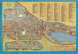
For the Convenience of Our Readers The New Yorker's Map of the 1940 World's Fair Together with an Index to its Chief Attractions.
sold
- Digital Map Information
- Suitable for large format printing
- File Size: 29.3 MB
- File Type: ZIP / TIFF
- ICC color profile embedded
- Delivered instantly via download link
This is a 1940 Carl Rose pictorial map of the 1939-40 New York World's Fair created for The New Yorker. The map depicts the fairgrounds, which were in today's Corona Park, from the Long Island Railroad tracks to the American Jubilee and from Lawrence Street and the Boy Scout Camp to the Transportation section and 111th Street. The focus of the map is the Trylon and Perisphere, the symbol of the World's Fair, and the Lagoon of Nations along the Flushing River. Pavilions, attractions, and restaurants throughout the fair are illustrated in profile and labeled. Most of the government and national pavilions are situated near the top of the fairgrounds around the Court of Peace, while pavilions dedicated to American industries and companies were built throughout the left half of the fair. Some pavilions focused on a theme, such as gas, religion, American Art, sports, science, and public health. Other buildings were erected by corporations, such as AT and T, Coca-Cola, DuPont, Eastman Kodak, General Motors, and Ford. The right portion of the map is dedicated to the Attraction section, which featured the popular Aquacade, Jungle Land, two penny arcades, bowling alleys, and numerous other amusements. Both the I.R.T. Subway and the B.M.T. Subway stations are noted. An index of all the sites throughout the fair is situated along the top border. The title cartouche, situated in the lower right corner, features a portrait of the dandy Eustace Tilly, a drawing by Rea Irvin that appeared on the cover of the first issue and symbolized the magazine ever since. (more details)
Rose's original art celebrating Lincoln Center's opening.
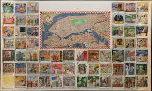
This is the original manuscript artwork for Carl Rose's 1962 map of New York, drawn for the New York Times Magazine special edition covering the opening of Lincoln Center. (more details)