
Sainte Hélène, Placide de (sold) (Placidium Augustinum)

Placide de Sainte Hélène (1648 - 1734), aka Placidium Augustinum, was a French geographer and Augustine monk. He is the brother of the French royal geographer to King Louis XIV, Pierre Du Val (1619 - 1683). He took orders in Augustine orders in 1666. In 1705, he was awarded the position of Géographe Ordinaire du Roi. Placidus, as he is known, contributed significantly to French and Dutch cartography in the late 17th and early 18th centuries. His name appears on dozens of maps, some very significant. He also completed a study of the Course of the Po River.
AKA: Placidium Augustinum
First edition of Visscher II's Portugal.
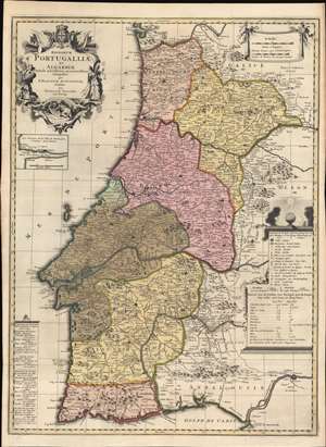
Regnorum Portugalliae et Algarbiae Tabula Novissima accuratissime Composita per P. Placidium Augustinum, et Edita par Nicolaum Visscher.
sold
- Digital Map Information
- Suitable for large format printing
- Full resolution TIFF file
- ICC color profile embedded
- Delivered instantly via download link
A striking c. 1700 old-color Nicholas Visscher II and Placide de Sainte Hélène map of Portugal, published at the height of Portugal's Golden Age, before the disastrous 1755 Great Lisbon Earthquake. The map depicts all of Portugal, including the Algarve and adjacent parts of Galicia, Leon, and Andalucía. An inset in the upper left quadrant illustrates the Duero River and Porto. Due to the contribution of the Augustinian geographer Placide de Sainte Hélène, this map is larger and considerably updated from previous Dutch maps of Portugal, including Visscher family maps. (more details)