
Sanson, Guillaume (sold)

Guillaume Sanson (1633 - 1703) was a French cartographer active in the latter part of the 17th century. He is the son of the legendary cartographer Nicolas Sanson (1600 - 1667), and, along with his brother Adrien Sanson (1639 - 1718), took over the family firm on his father's death. Like his father, Guillaume Louis XIV granted him the official title, Geographe Ordinaire du Roy. Much of his work after 1671 was published in collaboration with Alexis-Hubert Jaillot (c. 1632 - 1712). Although the continued to published new maps, particularly Guillaume Sanson, the firm began to lose prestige and market share. In 1692, the brothers sold their geographical archive to their nephew Pierre-Moulart Sanson (1670 - 1730), who published a map catalog in 1696 and reissued the Sanson atlas. After Pierre-Moulart's death, many of the surviving map plates were acquired by Gilles Robert de Vaugondy, setting the stage for another French cartographic dynasty.
Definitive 17th-Century French Map of North America. Rare state.
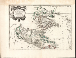
Amerique Septentrionale par N. Sanson Geographe du Roy.
sold
- Digital Map Information
- Suitable for large format printing
- File Size: 23.54 MB
- File Type: ZIP / TIFF
- ICC color profile embedded
- Delivered instantly via download link
This is Guillaume Sanson's 1669 map of North America, in its scarce second state of 1690. It is one of the most elegant expressions of 17th-century French cartography, presenting the dominant geographical model of the Americas of the period. The work was derived from the authoritative cartography of the French mapmaker Nicolas Sanson, whose authorship his son Guillaume emphasized in the cartouche. (more details)
Greece The Greek Islands during Venice's War with the Ottoman Empire.
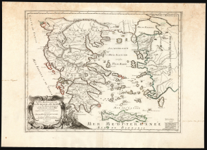
Partie Meridionale de la Turquie en Europe où sont les Beglerbeglicz de Romelie, et de la Mer dans lesquels sont remarquées les residences des Sanglacs qui en dependent: où sont encore l'Isle et la royaume de Candie, et les Isles de Corfou, Cephalonie, Zante, et autres Isles et places sur les Costes qui appartient aux Venetiens par le Sr. Sanson A Paris, chez Pierre Mariette rüe S. Jacques à l'Esperance avec privilége du Roy pur vingt ans. 1670.
sold
- Digital Map Information
- Suitable for large format printing
- Full resolution TIFF file
- ICC color profile embedded
- Delivered instantly via download link
This elegant, rare, French map of Greece, produced by Guillaume Sanson in 1670, presented a French audience with a view of Greece as a possession of the Ottoman Empire, wrestled over by the Venetian Republic - especially in the wake of the Cretan War (1645 - 1669) during which the Ottoman Empire had taken the island kingdom of Crete from Venice. The ongoing state of war is alluded to in the battle scene depicted to the right of the beautifully engraved cartouche, but the Ottoman occupation is indicated more cartographically than pictorially: a characteristic of the more scientific, factually-driven school of French mapmaking. (more details)
Ancient and modern Mapping of Crete.
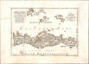
Creta Insula Plerûmq...
sold
- Digital Map Information
- Suitable for large format printing
- File Size: 18.67 MB
- File Type: ZIP / TIFF
- ICC color profile embedded
- Delivered instantly via download link
This is an elegant 1694 map, after Sanson, of the Greek island of Crete, combining modern topography with Roman-era toponymy. (more details)