
Seitosha (sold) (正統社)

Seitosha (正統社; fl. 1930 - 1949) was a Japanese publishing house active in Tokyo during the early to mid-20th century, particularly active during the wartime period of the 1930s and 1940s. Seitosha was known for official government publications, which, during this period, had a nationalistic and military leaning. During World War II, the Japanese government tightly controlled and censored publications, and Seitosha, like many other publishers, had to adhere to these strict regulations. After the war, with the democratization and demilitarization of Japan, many such publishing houses either adapted to the new environment or ceased operations. The fate of Seitosha is unclear, but we see no activity after 1950.
AKA: 正統社
Hawaii as part of the greater Japanese Empire.
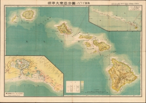
標準大東亞分圖 : ハワイ誻島 / Standard Map of the Great East Co-Prosperity Sphere. Hawaiian Islands.
sold
- Digital Map Information
- Suitable for large format printing
- Full resolution TIFF file
- ICC color profile embedded
- Delivered instantly via download link
This is a 1943 (Showa 18) Seitosha (正統社) map of Hawaii from the Greater East Asian Co-Prosperity Sphere series. The inclusion of the map in the Greater East Asian Co-Prosperity Sphere underscores the extent of Japan's imperial ambitions for the archipelago. It is part of a wider anti-western, anti-western-imperialism propaganda message promoted by Imperial Japan throughout the 1930s and 40s. (more details)
Japanese imperial interest in Luzon.
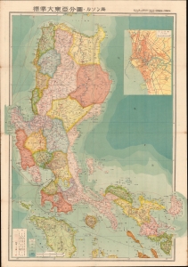
標準大東亞分圖 : ルソン島 / Standard Map of the Great East Asia: Luzon.
sold
- Digital Map Information
- Suitable for large format printing
- Full resolution TIFF file
- ICC color profile embedded
- Delivered instantly via download link
This is the 1943 (Showa 18) Seitosha (正統社) first edition map of Luzon, Philippines, from the Greater East Asia Co-Prosperity Sphere series. The inclusion of the map in the Greater East Asia Co-Prosperity Sphere underscores the extent of Japan's imperial ambitions for the archipelago. It is part of a broader anti-western anti-western-imperialism propaganda message promoted by Imperial Japan throughout the 1930s and 40s. (more details)
Japanese imperialistic Pan-Asianism.
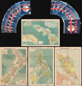
This is an important full set of 20 maps from the 1943 Showa 18 World War II (WWII) Greater East Asian Co-Prosperity Sphere series, by Seitosha (正統社). The maps cover from India to Hawaii and from Japan to Australia, reflecting the Japanese Imperial vision of Pan-Asianism. (more details)