
Shepherd, Edith Hawkins (sold)

Edith Hawkins Shepherd (June 4, 1918 - May 6, 2007) was an American artist based on Shelter Island, Long Island, New York. We have been able to trace few facts about Shepherd's life. She is listed in the 1980 New York census as living in Patchogue with her husband. At some point she relocated to Cartwright Town on the eastern side of Shelter Island. We have been told by people who knew her that she was a lively and active woman who enjoyed daily swims in Coecles Harbor, near her home, well into her 80s. Shepherd produced just one known map, a pictorial illustration of Shelter Island, first in 1950, with a revised edition in 1966.
A pictorial map of Shelter Island by Shelter Island local Edith Hawkins Sheperd.
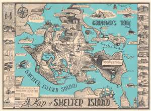
A Map of Shelter Island.
sold
- Digital Map Information
- Suitable for large format printing
- File Size: 31.08 MB
- File Type: ZIP / TIFF
- ICC color profile embedded
- Delivered instantly via download link
This is Edith Hawkins Shepherd's rare 1966 pictorial map of Shelter Island, Long Island. Shelter Island is 'sheltered' between the north and south forks of Long Island and retains much of its traditional charm amidst the glam and glitz of Hamptons. Shepherd identifies the basic geography of the island as well as local folklore (the place where Sachem Pogatticut watched the sunset), historical sites (such as the Westmoreland Clock Tower and the site of Lords' Shipyards), and more. The region's agricultural and maritime heritage are emphasized. Even Captain Kidd, the notorious pirate, is noted in the upper right. Historical buildings form sidebars to the left and right of the main map. (more details)
By Shelter Island local Edith Hawkins Shepherd.
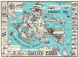
This is Edith Hawkins Shepherd's rare 1966 pictorial map of Shelter Island, Long Island. Shelter Island is 'sheltered' between the north and south forks of Long Island and retains much of its traditional charm amidst the glam and glitz of the Hamptons. Shepherd identifies the basic geography of the island as well as local folklore (the place where Sachem Pogatticut watched the sunset), historical sites (such as the Westmoreland Clock Tower and the site of Lords' Shipyards), and more. The region's agricultural and maritime heritage are emphasized. Even Captain Kidd, the notorious pirate, is noted in the upper right. Historical buildings form sidebars to the left and right of the main map. (more details)