
Simpson, James (sold)

James Simpson (fl. c. 1755 - 1770) was a British civil engineer and surveyor based in Jamaica and the wider British West Indies in the mid-18th century, a period marked by significant land acquisition, plantation expansion, and strategic mapping efforts under British rule. Details about his life are highly elusive. In the late 1750s, to at least 1761, he served as Chief Surveyor in Jamaica. By 1765, we find him in Dominica, where he produced a survey of Portsmouth, Charlotte-Town (Charlotte-Ville); then St. Vincent, where he surveyed Kingston; then Tobago, where he mapped Georgetown. Most of the surveys went unpublished and survive only in manuscript form.
Slave-suppression Masterplan.
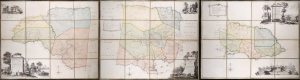
To the Right Honorable Robert Earl of Holdernesse, this map of the County of Cornwall, in the Island of Jamaica. (laid down from the papers, and under the direction of Henry Moore Esqr. His Majesty's Lieutenant Governor, and Commander in Chief of that Island, in the years 1756,-57,-58,-59,-60, and 61, and from a great number of actual surveys performed by the publishers) is humbly inscribed. / To the Right Honorable Wills Earl of Hillsborough, First Lord Commissioner of Trade and Plantations, this map of the County of Middlesex, in the Island of Jamaica. (laid down from the papers, and under the direction of Henry Moore Esqr. His Majesty's Lieutenant Governor and Commander in Chief of that Island in the years 1756,-57,-58,-59,-60, and 61, and from a great number of actual surveys performed by the publishers) is humbly inscribed. / To the Right Honorable George Grenville Esqr. First Lord Commissioner of the Treasury, Chancellor and under Treasurer of the Exchequers and c. and c. This map of the County of Surry, in the Island of Jamaica. (laid down from the papers and under the direction of Henry Moore Esqr. His Majesty's Lieutenant Governor and Commander in Chief of that Island in the years 1756,-57,-58,-59,-60, and 61, and from a great number of actual surveys performed by the publishers)is humbly inscribed.
sold
A seminal production, this is the 1763 Craskell-Simpson map of Jamaica, in three parts. It is the first broadly accurate map of Jamaica and the template for most subsequent representations of the island until the Roberston map of 1804. More importantly, the Craskell-Simpson map is best understood as a response to Tacky's Rebellion (April 1760 - October 1761) and, as such, is a masterplan for slave suppression. The map was commissioned by Henry Moore (1714 - 1769), who also, ironically, commissioned the Ratzer plan of New York, then likewise on the cusp of rebellion. It is the only work (either written or graphic) that records virtually every plantation and pen (large farms) in Jamaica at the height of the island's sugar boom, when it was the most valuable possession of the British Empire. (more details)