
Starling, Thomas (sold)

Thomas Starling (December 24, 1796 - June 15, 1850) was and English line engraver and map publisher based in London during first half of the 19th century. Starling was born in Islington and apprenticed as a stationer in 1811. He was in business for himself as early as 1818, from which time a surviving trade card (Bl 188.v.26) survives at the British Library. By 1824 he was in bankruptcy courts. He recovered somewhat, issuing the small format 1833 Family Cabinet Atlas and engraving Michael Alexander Gage's large format plan of Liverpool. Sterling was elected a Fellow of the Royal Geographical Society in 1833. He died in Essex in 1850.
Best and largest map of Liverpool of the 19th century.
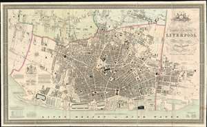
This Trigonometrical Plan of the Town and Port of Liverpool including the environs of Kirkdale Everton Low Hill Edge Hill and Toxteth Park from Actual Survey.
sold
- Digital Map Information
- Suitable for large format printing
- DPI: 600
- File Size: 159.52 MB
- File Type: ZIP / TIFF
- ICC color profile embedded
- Delivered instantly via download link
The finest 19th century large format city plan or map of Liverpool, England. Published by Michael Alexander Gage, this first edition map is oriented to the northeast and details the city from Kirkdale to Toxteth Park and eastward as far as Edge Hill. Throughout the plan exhibits extraordinary and meticulous detail, noting every house with its layout, as well as roads, churches, parks, and even individual trees - a testament to Gage's often overshadowed skills as an engraver. In addition, important businesses, including foundries, lumber yards, cooperages, shipbuilders, chrome works, color works, soap makers, breweries, and more are noted - often by their individual company names. (more details)