
Stelzer, Otto Emil (sold)

Otto Emil Stelzer (January 5, 1901 - April 1984), was a Swiss-German artist, poet, inventor, entrepreneur, sculptor, and engraver active in Chicago, Illinois; South Bend, Indiana; and Phoenix, Arizona. Stelzer was born in St. Gall, Switzerland. He emigrated to the United States in 1923, initially settling in South Bend, Indiana. He lived briefly in Chicago from 1920 - 1934, but relocated to German, St. Joseph, Indiana by 1935. During this period, in 1933, Stelzer produced two maps, a historical map of South Bend, Indiana as it appeared in 1831, and, in partnership with Walter Haddon Conley (1893 - 1936), a map of Chicago as it appeared in 1933. In 1941 he was employed as a commercial artist with the firm 'Advertising Artists' of South Bend, Indiana. Stelzer also, apparently, dabbled in poetry and was an inventor. For many years, he owned and managed the Aluminum Manufacturing Plant in South Bend, Indiana, from which he retired in 1969. Around this time, he relocated to Phoenix, Arizona, establishing Stelzer Studio, where he dabbled in sculpture, creating lamps, wall sculptures, and candelabras. He died in Phoenix, Arizona, in late April, 1984. In some references Stelzer's name is occasionally miswritten as 'D.E.'
A rare Chicago Sunday Tribune edition of Conley and Stelzer's iconic map of Chicago.
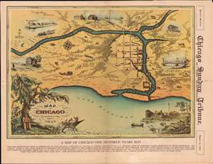
A Map of Chicago Incorporated as a Town August 5, 1833.
sold
- Digital Map Information
- Suitable for large format printing
- File Size: 23.06 MB
- File Type: ZIP / TIFF
- ICC color profile embedded
- Delivered instantly via download link
This is a beautiful 1933 pictorial map of Chicago issued by Walter Conley and Otto Emil Stelzer to commemorate the centennial of the founding of Chicago in 1833 for the 1933 Century of Progress Exhibition / World's Fair. Oriented with north to the right, it depicts Chicago at the time of its incorporation in 1833, when it was just a small settlement. The Chicago River is identified as it empties into Lake Michigan. The Town of Chicago is noted to have a population of 350. Throughout, the map notes trails, roads, swamps, and forests. (more details)