
Thomas, Henry (sold)

Henry Thomas (1837 - 18??) was a lithographer, engraver, and printer based in Holyoke, Massachusetts in the second half of the 19th century. Thomas was born in France. Due to his rather name, it is nearly impossible to distinguish Thomas from numerous other individuals of the same name, living in the same region. His offices were located in the Bowers and Mosher Buildings, just opposite the railroad depot in Holyoke. His advertisements appear in local until about 1885.
Holyoke, published in Holyoke.
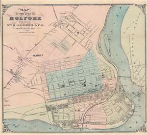
Map of the City of Holyoke.
sold
- Digital Map Information
- Suitable for large format printing
- Full resolution TIFF file
- ICC color profile embedded
- Delivered instantly via download link
This is a c. 1871 William Loomis city plan or map of Holyoke, Massachusetts, a historic mill town on the Connecticut River. Holyoke is located in the famous 'Five Colleges' region of the Pioneer Valley. The 'five' include Amherst College, Hampshire College, Mount Holyoke College, Smith College, and the University of Massachusetts Amherst. Holyoke is divided into wards, shaded a different for easy differentiation. Buildings are illustrated throughout, many of which are labeled, including the grammar school, high school, city hall, numerous businesses, and churches. Three freight canals cut through the city, and the Connecticut River Railroad runs along the Connecticut River. The whole is surrounded by a beautifully engraved border. (more details)