
Union Lithography Company (sold)

Union Lithography Company (1888 - 1948) was a San Francisco and Oakland based printing concern active in the late 19th and early 20th centuries. The firm was originally founded 1888 by the former Providence, Rhode Island printer, Jennison Clifton Hall (March 22, 1840 - May 20, 1898), as J. C. Hall and Company. Previously, Jennison was running a firm in Providence partnered with John E. Bugbee under the imprint of Bugbee and Hall. J. C. Hall and Company was renamed Union Lithography sometime around 1890. Hall died unexpectedly of a heart attack in 1898, but the firm continued. The firm met with considerable success until its offices were destroyed during the 1906 San Francisco Earthquake. Later that year, to supplement their crippled printing capacity, Union purchased the Los Angeles Lithographic Company. Union was purchased by the H.S. Crocker and company in 1922, but retained its name until 1936, when the firms began publishing under the unified Crocker-Union imprint. The consolidated firm remained active until about 1948.
Berkeley, meet Art Deco!
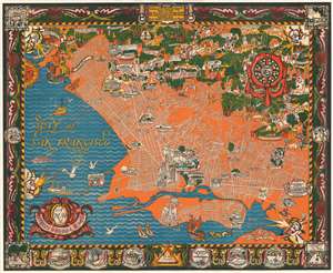
A Map of Berkeley, Oakland and Alameda.
sold
- Digital Map Information
- Suitable for large format printing
- File Size: 110.52 MB
- File Type: ZIP / TIFF
- ICC color profile embedded
- Delivered instantly via download link
This is an outstanding c. 1930 large-format art deco chromolithograph pictorial map of Berkeley, Oakland, and Alamada County, California. The map was issued by the Berkeley artists Michael A. Baltekal-Goodman and Eugene (Eugen) Neuhaus, both then at U.C. Berkeley. Coverage extends from the San Francisco Bay to the Berkeley Hills. The artists have employed a bold color scheme that contracts the blue of San Francisco Bay with the orange and white Berkeley-Oakland street grid. Pictorial elements include vignette illustrations of significant buildings and other attractions. In the hills to the northeast, the focus is more on cultural references, natural beautify, and wildlife. The map features a decorative border with numerous vignettes illustrating historical events, ranging from an 1874 temperance protest to dueling. (more details)