
Ureta Martínez, Horacio (sold)

Professor Horacio Ureta Martínez (18xx - 19xx) was a private cartographer in Uruguay. Called the 'best private cartographer in Uruguay' by the U.S. Central Intelligence Agency, Ureta Martínez worked on the staff of the Sección de Estadística Agronómica of the Ministerio de Agricultura. His work included compiling maps of departments of Uruguay. He also produced map for propaganda and school use. While working alone, Ureta Martínez produced wall maps, illustrations for geography textbooks, and an atlas. He also produced maps of Uruguay's departments on varying scales, general maps of Uruguay, and a pictorial relief map with political, economic, and climatic insets. In 1950, he joined the cartographic staff of the United Nations Secretariat.
Detailed map of Uruguay.
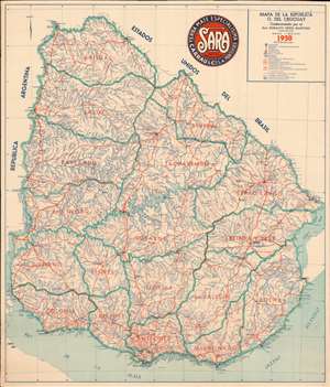
Mapa de la Republica O. del Uruguay.
sold
- Digital Map Information
- Suitable for large format printing
- File Size: 43.53 MB
- File Type: ZIP / TIFF
- ICC color profile embedded
- Delivered instantly via download link
This is a 1950 Horacio Urete Martinez map of Uruguay. Teal lines outline Uruguay's departments, and orange block lettering identifies each one. Orange lines also trace Uruguay's railroads, as well as three different road grades: main roads, secondary roads, and local roads. Cities and towns are labeled, with Montevideo situated near the bottom of the map along the Rio de la Plata. (more details)