
Keulen, Johannes II van (sold)

Johannes II van Keulen (1704 - 1755) was a Dutch map publisher, engraver, chartmaker, and instrument seller active in Amsterdam in the first half of the 19th century. He is a scion of the significant van Keulen publishing dynasty and, after his grandfather of the same name (1654 - 1715), the most important figure in that family's long publishing history. Johannes II's father was Gerard van Keulen (1678 - 1726). Like his father and grandfather, Johannes II was appointed hydrographer to the VOC (Vereenigde Oostindische Compagnie / United Dutch East India Company), inheriting the position on his father's 1726 death. He was elevated to chief VOC cartographer in 1743. In the next year, 1744, Jan Harmenszoon de Marre (1696 - 1763), Examiner of the Amsterdam Chamber of the VOC, was ordered to work with Johannes II to compile a new volume of the trademark van Keulen Zee-Fakkel, based upon manuscript nautical charts of the East Indies and East Asia long kept secret by the VOC. This work, published in 1753 as volume 6 of the Zee-Fakkel, was the first printing of the VOC's most tightly guarded secrets. The work was not intended for public sale, rather, it was meant to consolidate and improve upon the older, often contradictory, VOC manuscript charts. It became known as the 'Secret Atlas', as its use was restricted to VOC pilots who were issued the volume at the outset of a voyage, and expected to surrender it on the return. Although any VOC official, including van Keulen, with access to the atlas was placed under bonds of secrecy, data did eventually leak. Many of the maps, superior to anything previously obtainable, laid the foundation for subsequent charts published by English, French, and other Dutch cartographers. When Johannes II died, the business passed to his son, Gerard Hulst van Keulen (1733 - 1801).
Earliest Accurate Printed Plan and Chart of Havana.
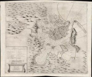
De Stad en Haven van Havana, op't Eÿland Cuba, met alle desselfs Droogtens en Dieptens...
sold
- Digital Map Information
- Suitable for large format printing
- Full resolution TIFF file
- ICC color profile embedded
- Delivered instantly via download link
This is a rare, beautifully engraved map and plan of Havana and its bay by the Dutch chart maker Johannes van Keulen. Its dating is not well understood, but it can be placed c. 1720 on contextual grounds. It is the earliest printed, accurate charting of Havana Bay and the earliest accurate depiction of Old Havana. The chart reflects a profound shift in Dutch-Spanish relations, documenting the emergence of robust commercial cooperation following the War of Spanish Succession (1701 - 1714) after more than 150 years of political and military hostility. (more details)
VOC's Secret Map of the critical passage around Madagascar to the Indies.
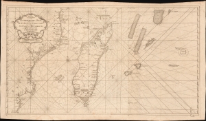
Paskaart van een Gedeelte van de Aethiopische-Zee, Strekkende van R. Sta. Lucia tot C. del Gado, Langs de Kusten van Suffalo en Mocambique, Bevattende Insgelyks 't Eiland Madagascar met Desselfs Onderhorige Eilanden.
sold
- Digital Map Information
- Suitable for large format printing
- File Size: 45.51 MB
- File Type: ZIP / TIFF
- ICC color profile embedded
- Delivered instantly via download link
This is an extremely rare 1753 Johannes II van Keulen / Jan de Marre nautical map of Madagascar, Mauritius, and the adjacent coast of Africa compiled for the sixth volume of the Zee-Fakkel - the Dutch East India Company's legendary 'Secret Atlas.' The map reveals tightly controlled navigational secrets when Madagascar was a haven not only for the world's most notorious pirates (including Captain Kidd) but also a source for the Atlantic Slave Trade. (more details)
The VOC's Secret Map of the South China Sea.
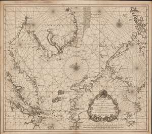
Nieuwe Caart strekkende van Banca, langs de kusten van Malacca, Siam, Cambodia, Cochinchina, als meede een gedeelte van de Eylanden Luçon, Borneo, et c. met alle dresslss Havens, Dieptens en Ankergronden.
sold
- Digital Map Information
- Suitable for large format printing
- DPI: 600
- File Size: 580.26 MB
- File Type: ZIP / TIFF
- ICC color profile embedded
- Delivered instantly via download link
The rare 1753 Johannes II van Keulen / Jan de Marre nautical map of the South China Sea compiled for the sixth volume of the Zee-Fakkel - the legendary Dutch East India Company (VOC - Vereenigde Oostindische Compagnie) 'Secret Atlas.' The map covers the South China Sea and Gulf of Thailand - thus embracing Singapore, Malaya, southern Thailand (Siam), Cambodia, southern Vietnam, most of Borneo, and parts of the Philippines. The map illustrates the most important waters and most dangerous sea passages in the East Indies. It was an essential navigational reference for VOC ships sailing from Malacca, through the Straits of Singapore, or north from Batavia for Siam (Bangkok), Laauwec (Cambodia), Nagasaki, Canton (Guangzhou), Macao, or Manila. (more details)