
Wechel, Chrétien (sold)

Chrétien Wechel (1495 - 1554), or Christianus Welchlus, was a French printer active in Paris in the first half of the 16th century. Wechel was born in Herentals, Brabant, near Antwerp. He married Michelle Robillart, a widow who, through her deceased husband Jean Périer, was well connected in French literary and publishing circles. He moved to Paris around 1519 and was naturalized as a French citizen in 1528. In August of 1526, Wechel and Robillart acquired the Paris business of the Swabian bookseller and printer Conrad Resch (Resch was relocating to Basel), for whom Wechel worked as a manager. Wechel expanded the publishing arm of the already significant bookshop, adding his own presses by 1528. Wechel specialized in Greek, Hebrew and Humanist prints. He embraced the ideas of Martin Luther and the French evangelicals. He published the 1540 edition of Oronce Finé's (1494 - 1555) important Nova, et Integra Universi Orbis Descriptio. When Wechel died in 1554, his son André Wechel took over the Paris business, which he ran until 1573. He relocated the business to Frankfurt-am-Main, where it was active from 1573 to 1581.
One of the Finest and Most Detailed Woodcut World Maps.
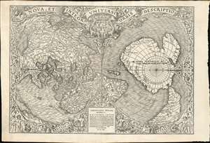
Nova, et Integra Universi Orbis Descriptio.
sold
- Digital Map Information
- Suitable for large format printing
- Full resolution TIFF file
- ICC color profile embedded
- Delivered instantly via download link
This the rare and influential 1531 Oronce Fine map of the world, portrayed using a double cordiform polar projection. This intricate woodcut map was both influential and - especially compared to other printed maps of its era - remarkably reflective of state-of-the-art cartographic detail. Rodney Shirley proclaimed it 'a rendering considerably in advance of any others printed earlier.' Many areas of significant interest are addressed in detail for the first time. The peninsular shape of Florida is clearly presented for the first time, and both Pineda and Cortez' mapping of the Gulf of Mexico are recorded here. This is the first printed map to refer to Magellan's voyage, naming a 'Mare Magellanicum' west of South America. The map breaks from Martin Waldseemüller's convention of presenting North America as separate from Asia: Fine's map incontrovertibly presents Labrador, Florida and the Gulf Coast as part of the Asian mainland; South America itself is depicted as taking the place of the Ptolemaic Great Promontory, or 'Dragon's Tail' that appeared on earlier maps like the 1507 Waldseemüller and the 1490 Martellus. Although including (but not naming) Magellan's strait, the map fails to account for the size of the ocean that circumnavigator revealed (despite naming that ocean - Mare Magellanicum.) (more details)