
Yves et Barret (sold)

Yves et Barret (fl. c. 1870 - 1890) were French engravers active in the late 19th century. They engraved political cartoons and other images for French periodicals, including La Vie Parisienne. This partnership was known for creating works using gillotage, a now obsolete lithographic process wherein a drawing was made on or transferred to zinc and then dusted with resin, which adhered to the drawing. The resin then acted as an acid-resist when the entire plate was immersed in acid, creating a relief block that could then be inked and printed from. This printing technique was popular with newspapers, as it was completely compatible with blocks of type.
Europe after the Franco-Prussian War.
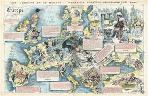
L'Europe en Ce Moment - Fantaise Politico-Géographique.
sold
- Digital Map Information
- Suitable for large format printing
- File Size: 21.65 MB
- File Type: ZIP / TIFF
- ICC color profile embedded
- Delivered instantly via download link
This is an 1872 Yves and Barret caricature map of Europe after the Franco-Prussian War. Coverage embraces all of Europe, from the Atlantic Ocean to the Caspian Sea and from Scandinavia and the Shetland Islands to the Mediterranean Sea. Illustrated personifications of each nation define the author's political viewpoints. Newly united Germany dominates central Europe in the form of the Kaiser, who is sprawled across what the French must have considered to be an ominously large territory. He reclines against a cannon and artillery shells, accompanied by a gigantic sword and an empty beer stein - suggesting at once military power, belligerence, and instability. A much smaller German soldier is illustrated holding the puppet strings of several other European countries, including Italy, Spain, and Austria. France, which had just lost the Franco-Prussian War, is represented as Marianne, the French national symbol, being tended by smaller officials and military men. The men are trying to get her to hold back her anger at having German guns pointed at her from Strasbourg (Alsace and Lorraine were annexed by Germany after the Franco-Prussian War) and to form a new government following the defeat, as well as the chaos of the Paris Commune. England is illustrated as a man in armor decorated with the Union Jack holding a book for a shield. He is surrounded by the Bible and bales of cotton. Spain, Italy, and Austria are depicted as contentedly going about their business, per the German soldier's wishes, but the Austrians are illustrated holding scissors, possibly to try to cut ties with the now overly powerful Germany. Russia is a frozen wasteland with their onion-domed churches and a land where everything happens 'because the czar wants it to be'. The Turks represented as a caricature of eastern decadence: a single man surrounded by elegantly dressed women attending to his every whim. (more details)
Highlights the romantic activities of high society individuals in an imaginary France known as the Country of Love.
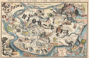
Nouvelle Géographie du Pays du Tendre. -- 2me Carte: Province du High-Life.
sold
- Digital Map Information
- Suitable for large format printing
- Full resolution TIFF file
- ICC color profile embedded
- Delivered instantly via download link
This is an 1881 Sahib pictorial map of the province of High Society or High-Life in the Country of Love or Pays du Tendre, and illustrates possible activities in the love lives of high-class individuals, and high society in general. New-Cythère, the capital of the Pays du Tendre, is situated in the upper left corner and is occupied by no less than six 'Venuses', which references the fact that Cythère, in mythology, is the island where Aphrodite appears after she is born from the sea. The River of Love (Le Tendre Fleuve) practically encircles High-Life which contains numerous different sites. Leisure activities of the upper crust, such as ice skating, lawn tennis, and yachting, are referenced, as are staples of romance in high society, including bouquets of flowers and candy (les bonbons). Music, dancing, 'castle life' (vie de chateau), and dinner at a cabaret are other highlights of life here. The Heart River (Le Coeur Fleuve) nearly cuts the province in two, with a different genre of activities illustrated above the river than below. Above the river, one finds politics, academia, diplomacy, art exhibitions, charity concerts, and the opéra-comique, and below the river 'innocent games' (jeux innocents), swimming, music, and dancing appear. Other sites throughout the map include the 'Rocks of Virtue' (Rochers de la Vertu), the 'River of Platonic Love' (L'amour Platonique Riviere), the Chasm of Marriage (Gouffre du Mariage), and the 'Swamp of Collage (Marais du Collage). Collage is a French slang term which is defined as 'living as husband and wife in an unmarried state'. The whole provides an intriguing commentary on romance in high society. (more details)
A pictorial map of the provinces of 'fashionable prostitution' and 'whoredom' in the Country of Love.
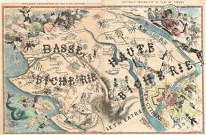
Nouvelle Géographie du Pays du Tendre.
sold
- Digital Map Information
- Suitable for large format printing
- File Size: 18.22 MB
- File Type: ZIP / TIFF
- ICC color profile embedded
- Delivered instantly via download link
This is an 1881 Sahib pictorial map of the provinces of prostitution in the country of love. Published in the December 24, 1881 issue of La Vie Parisienne, the map depicts the provinces of Haute Bicherie 'fashionable prostitution' and Basse Bicherie (roughly translates to 'whoredom'). The entire map of the Pays du Tendre is shaped more or less like France, with New-Cythère, the capital of the Pays du Tendre placed roughly in the same location as Paris. Cythère, in mythology, is the island where Aphrodite appears after she is born from the sea. This mythology is referenced in the iconography used on the map, since there is a very beautiful woman illustrated right next to New-Cythère and a cherub with a bow and arrow, probably a reference to Eros, the Greek god of love, who was Aphrodite's son. (more details)