
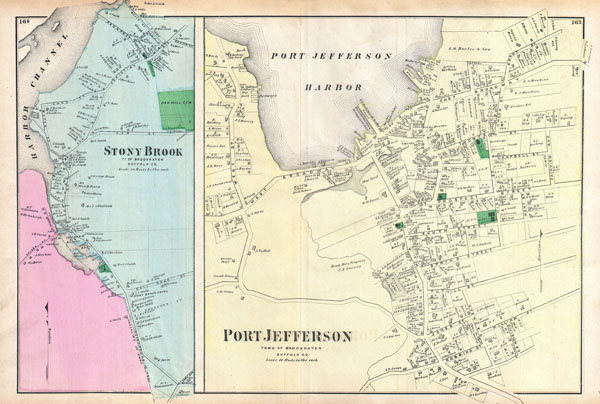
Port Jefferson, Town of Brookhaven, Suffolk Co. / Stony Brook, Town of Brookhaven, Suffolk, Co.
sold
- Digital Map Information
- Suitable for large format printing
- File Size: 13.27 MB
- File Type: ZIP / TIFF
- ICC color profile embedded
- Delivered instantly via download link
A scarce example of Fredrick W. Beers' map of Port Jefferson and Stony Brook, Long Island, New York. Published in 1873. Two maps on one sheet. Left hand side of the maps depicts the town of Stony Brook from the Harbor Channel to the Oak Hill Cemetery. This area ... (more details)
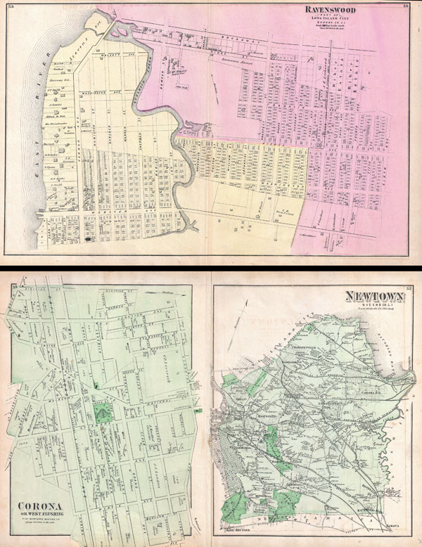
Ravenswood, Part ofLong Island City, Queens, Co. L.I. / Newtown Queens Co. L.I. / Corona or West Flushing, Town of Newtown, Queens Co.
sold
- Digital Map Information
- Suitable for large format printing
- File Size: 23.68 MB
- File Type: ZIP / TIFF
- ICC color profile embedded
- Delivered instantly via download link
A scarce example of Fredrick W. Beers' two map set of Ravenswood, Queens, New York City. Published in 1873. Maps printed on both sides of sheet. Ravenswood side details Ravenswood, Queen from the East River to what was then 6th Avenue. Bounded on the north by ... (more details)
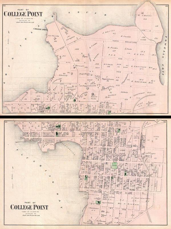
Part of College Point, Town of Flushing, Queens Co. / Part of College Point, Town of Flushing, Queens Co.
sold
- Digital Map Information
- Suitable for large format printing
- File Size: 19.21 MB
- File Type: ZIP / TIFF
- ICC color profile embedded
- Delivered instantly via download link
A scarce example of Fredrick W. Beers' two map set of College Point, Queens, New York. Published in 1873. Bottom sheet covers roughly from what was then 9th Avenue northward as far as what was then 2nd avenue. Top sheet continues from 2nd avenue to College ... (more details)

North Hempstead / Port Washington, Town of North Hempstead, Queens, Co. / Manhaset, Town of North Hempstead, Queens Co. / Mineola, Town of North Hempstead, Queens Co.
sold
- Digital Map Information
- Suitable for large format printing
- File Size: 25.95 MB
- File Type: ZIP / TIFF
- ICC color profile embedded
- Delivered instantly via download link
A scarce example of Fredrick W. Beers' map of North Hempstead, Port Washington and Roslyn, New York. Published in 1873. Covers roughly from Little Neck Bay and Great Neck eastward past Manhasset to New Cassel. Includes large inset plans of the towns of ... (more details)
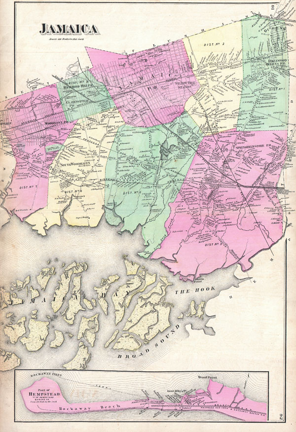
Jamaica.
sold
- Digital Map Information
- Suitable for large format printing
- File Size: 14.8 MB
- File Type: ZIP / TIFF
- ICC color profile embedded
- Delivered instantly via download link
A scarce example of Fredrick W. Beers' map of Jamaica, Queens, New York City. Published in 1873. Covers roughly from Jamaica Bay northward as far as Jamaica Center and Inglewood. Includes an inset plan of Rockaway Beach and Brant Point. Includes the ... (more details)

Part of Brookhaven, Sufffolk Co. L.I.
sold
- Digital Map Information
- Suitable for large format printing
- File Size: 14.26 MB
- File Type: ZIP / TIFF
- ICC color profile embedded
- Delivered instantly via download link
A scarce example of Fredrick W. Beers' map of the northern part of Brookhaven, Long Island, New York. Published in 1873. Covers roughly from Smithtown Bay and Cranes Neck eastward as far as Manorville and Wading River. Shows the Smithtown and ... (more details)

Flatbush Town of Flatbush Kings Co. L.I.
sold
- Digital Map Information
- Suitable for large format printing
- File Size: 14.14 MB
- File Type: ZIP / TIFF
- ICC color profile embedded
- Delivered instantly via download link
A scarce example of Fredrick W. Beers' map of the Flatbush area of Brooklyn, New York. Published in 1873. Oriented to the west. Covers roughly from modern day Regent Place northward as far as the southeast corner of Prospect Park. Extends ... (more details)

U.S. Coast Survey Sketch C Showing the Progress of the Survey in Section No. III from 1843 to 1857.
sold
- Digital Map Information
- Suitable for large format printing
- File Size: 21.81 MB
- File Type: ZIP / TIFF
- ICC color profile embedded
- Delivered instantly via download link
A beautiful preliminary triangulation chart of the Chesapeake Bay area published in 1857 for the U.S. Coast Survey Report. Covers from the entrance of the Bay at Cape Henry northward to the entrance to the Susquehanna River. Extends ... (more details)
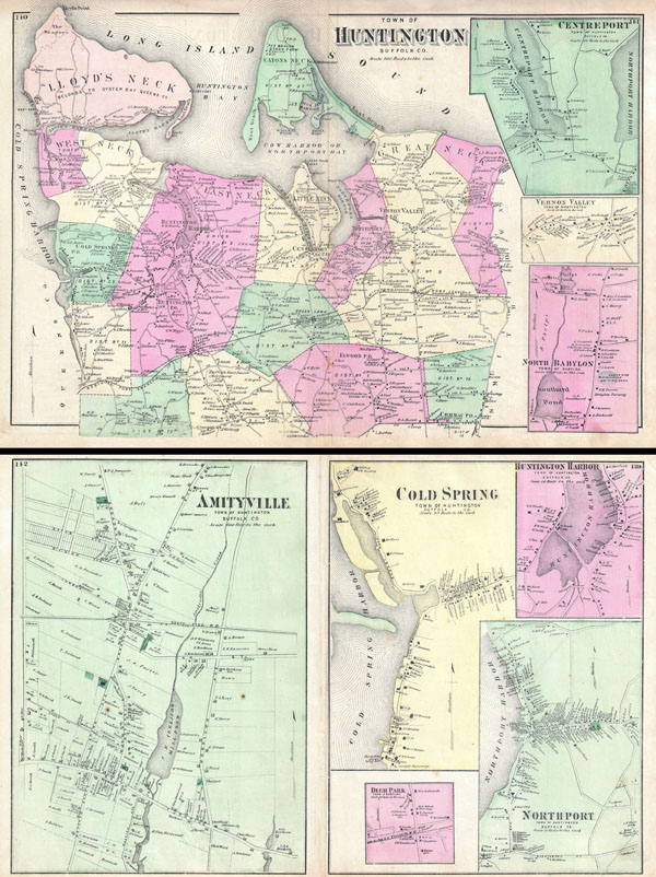
Town of Huntington, Suffolk Co. / Amityville, Town of Huntington, Suffolk Co. / Cold Spring, Town of Huntington, Suffolk Co.
sold
- Digital Map Information
- Suitable for large format printing
- File Size: 22.53 MB
- File Type: ZIP / TIFF
- ICC color profile embedded
- Delivered instantly via download link
A scarce example of Fredrick W. Beers' map of Huntington, Long Island, New York. Published in 1873. Covers the Huntington area from Cold Spring Harbor eastward past West Neck, East Neck, Huntington Harbor, Little Neck, to Great Neck ... (more details)
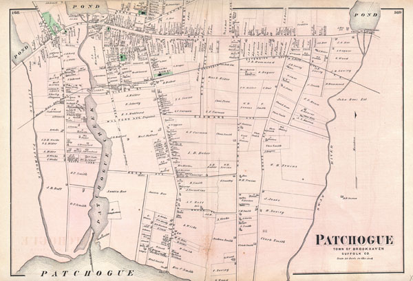
Patchogue, Town of Brookhaven, Suffolk Co.
sold
- Digital Map Information
- Suitable for large format printing
- File Size: 11.28 MB
- File Type: ZIP / TIFF
- ICC color profile embedded
- Delivered instantly via download link
A scarce example of Fredrick W. Beers' map of the town of Patchogue, Long Island, New York. Published in 1873. Detailed to the level of individual properties with land holders noted. This is probably the finest atlas map of ... (more details)

Flushing, Queens Co. L.I.
sold
- Digital Map Information
- Suitable for large format printing
- File Size: 12.47 MB
- File Type: ZIP / TIFF
- ICC color profile embedded
- Delivered instantly via download link
A scarce example of Fredrick W. Beers' map of Flushing and College Point, Queens, New York. Published in 1873. Covers part of what is today northern Queens, New York City, including Flushing, College Point, Whitestone and ... (more details)

Hunters Point, Part of Long Island City.
sold
- Digital Map Information
- Suitable for large format printing
- File Size: 14.03 MB
- File Type: ZIP / TIFF
- ICC color profile embedded
- Delivered instantly via download link
A scarce example of Fredrick W. Beers' map of the Hunter's Point (Hunters Point), Queens, New York. Published in 1873. Covers part of what is today Long Island City from Pier Street north as far as Nott Avenue. Shows the ... (more details)

Design Map of Sea Cliff Grove, Glen Cove, L.I.
sold
- Digital Map Information
- Suitable for large format printing
- File Size: 14.76 MB
- File Type: ZIP / TIFF
- ICC color profile embedded
- Delivered instantly via download link
A scarce example of Fredrick W. Beers' map of the Sea Cliff Grove, Long Island, New York. Published in 1873. Sea Cliff Grove, named for the bluff on which it is situated, was founded in the late 19th century as a ... (more details)
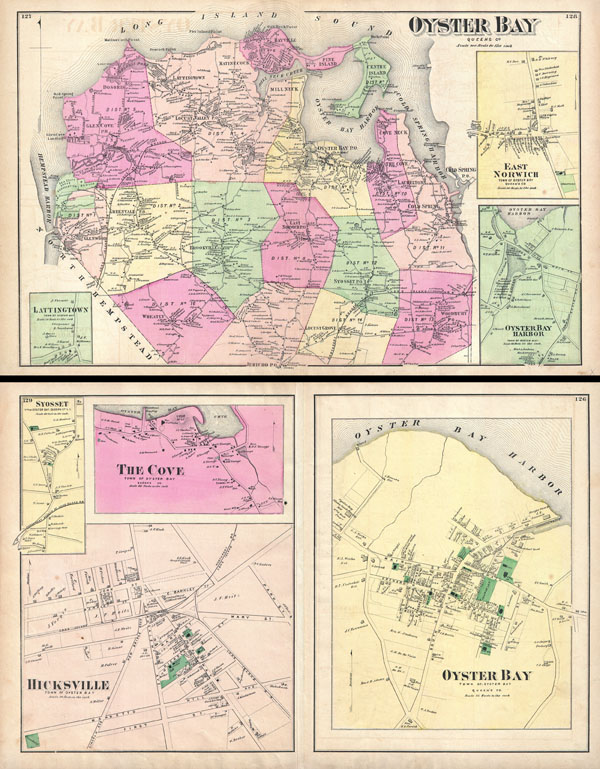
Oyster Bay, Queens Co. / Oyster Bay, Town of Oyster Bay, Queens Co. / Hicksville, Town of Oyster Bay.
sold
- Digital Map Information
- Suitable for large format printing
- File Size: 23.68 MB
- File Type: ZIP / TIFF
- ICC color profile embedded
- Delivered instantly via download link
A scarce example of Fredrick W. Beers' map of the Oyster Bay, Long Island, New York. Published in 1873. Oyster Bay side of map sheet covers from Hempstead Harbor eastward as far as Cold Spring Harbor. Bounded on ... (more details)

Islip, Suffolk, Co. / Islip, Town of Islip, Suffold Co. / Bay Port, Town of Islip, Suffold Co. / Sayville, Town of Islip, Suffold Co.
sold
- Digital Map Information
- Suitable for large format printing
- File Size: 22.82 MB
- File Type: ZIP / TIFF
- ICC color profile embedded
- Delivered instantly via download link
A scarce example of Fredrick W. Beers' map of the Islip and Sayville, Long Island, New York. Published in 1873. Islip side covers from Babylon Cove and West Islip eastward past Bay Shore, Islip, young Point, ... (more details)
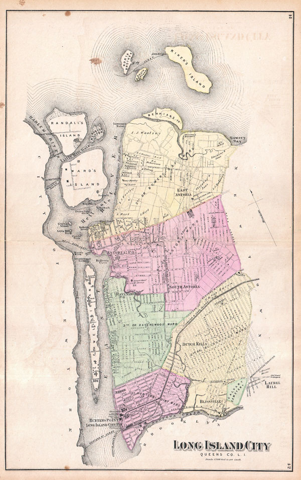
Long Island City, Queens Co.L.I.
sold
- Digital Map Information
- Suitable for large format printing
- File Size: 12.85 MB
- File Type: ZIP / TIFF
- ICC color profile embedded
- Delivered instantly via download link
A scarce example of Fredrick W. Beers' map of the Long Island City, Queens, New York. Published in 1873. Covers from Hunters Point and Long Island City northward past Ravenswood and Dutch Kills to include ... (more details)
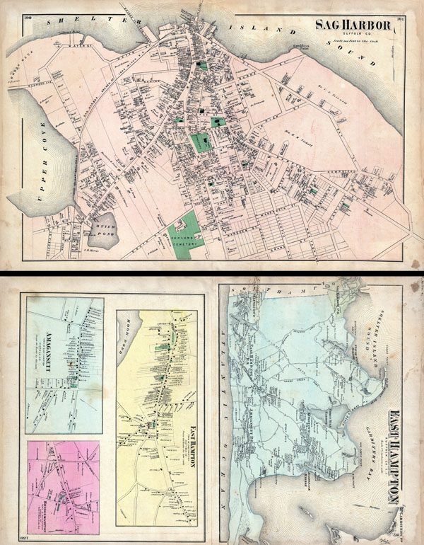
East Hampton, Suffolk Co. L.I. / Sag Harbor, Suffolk Co.
sold
- Digital Map Information
- Suitable for large format printing
- File Size: 25.12 MB
- File Type: ZIP / TIFF
- ICC color profile embedded
- Delivered instantly via download link
A scarce example of Fredrick W. Beers' map of the Sag Harbor and East Hampton, Long Island, New York. Published in 1873, this map is printed on both sides. On the Sag Harbor Side, this magnificent map ... (more details)

Babylon Suffolk Co.
sold
- Digital Map Information
- Suitable for large format printing
- File Size: 8.26 MB
- File Type: ZIP / TIFF
- ICC color profile embedded
- Delivered instantly via download link
A scarce example of Fredrick W. Beers' map of the southern part of Huntington and Babylon, Long Island, New York. Published in 1873, this magnificent map covers from Amityville to Babylon Cove. Extend ... (more details)

South part of Hempstead, Queens Co. L.I.
sold
- Digital Map Information
- Suitable for large format printing
- File Size: 15.07 MB
- File Type: ZIP / TIFF
- ICC color profile embedded
- Delivered instantly via download link
A scarce example of Fredrick W. Beers' map of the southern part of Hempstead, Long Island, New York. Published in 1873, this magnificent map covers from Jamaica Bay and Far Rockaway eastward past Hicks ... (more details)
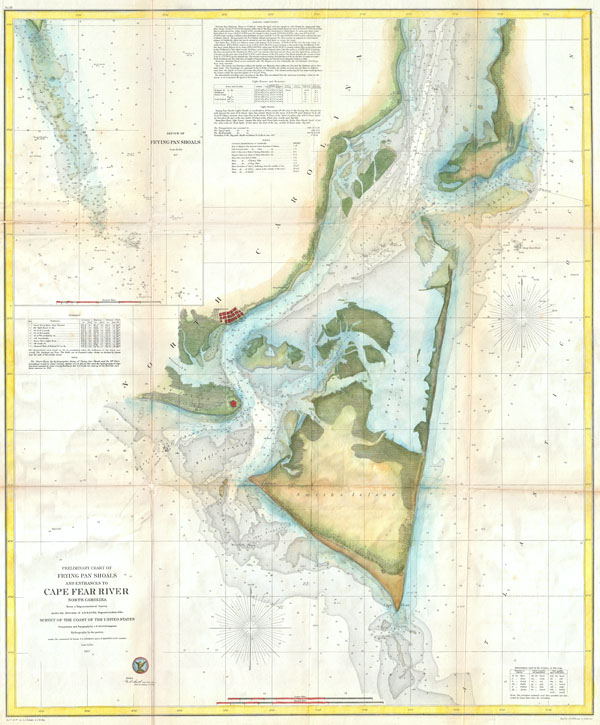
Preliminary Chart of Frying Pan Shoals and Entrances to Cape Fear River North Carolina.
sold
- Digital Map Information
- Suitable for large format printing
- File Size: 25.25 MB
- File Type: ZIP / TIFF
- ICC color profile embedded
- Delivered instantly via download link
One of the largest and most striking U.S.C.S. Maps of North Carolina's Cape Fear. Extends from Federal Point south to the top of Cape Fear and then west past Smithville and Fort Caswell to Oak Island ... (more details)