
CartoCuriosity - Buried Ships of San Francisco
CartoCuriosity - Buried Ships of San Francisco
During the California Gold Rush, fortune seekers scoured the earth for buried treasure. In the process, they left behind something unexpected: ships that would themselves become buried treasures.
Discover the hidden history beneath the streets of San Francisco in this episode of CartoCuriosity, where Kevin Brown of Geographicus Rare Antique Maps and Michael Jennings of Neatline Antique Maps examine a unique 1850 manuscript map documenting the city's legendary buried ships. Created during the height of the California Gold Rush, this extraordinary map captures the explosive growth of early San Francisco, revealing its original shoreline, Central Wharf, and abandoned vessels that were engulfed by land reclamation as the city expanded. Learn how one of these ships, the Arkansas, was identified through modern archaeology, and discover why this remarkable artifact offers an unparalleled window into Gold Rush history, 19th-century cartography, maritime archaeology, and the forgotten city buried beneath modern San Francisco.
Featuring Kevin Brown from Geographicus Rare Antique Maps and Michael Jennings from Neatline Maps
Produced by Cory Choy, Tom Fama, and Christian Cuciniello
Edited by Jada Mackinnon. Sound by Silver Sound
2026-01-09
A Closer Look at the Map
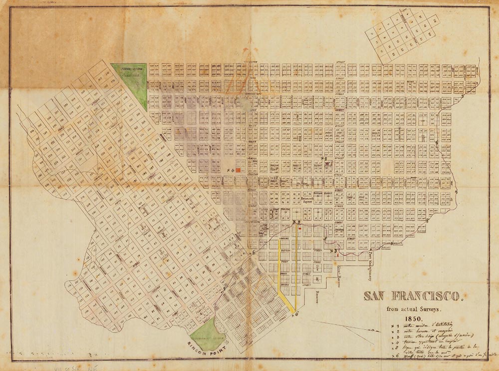
A unique artifact of Gold Rush San Francisco, including one of San Francisco’s most famous buried ships!
Podcast Summary:
Gold Rush chaos, abandoned ships, and a manuscript map that reveals a hidden city beneath San Francisco.
Gold Rush chaos, abandoned vessels, and a manuscript map that reveals a hidden city beneath the city
During the California Gold Rush, fortune seekers scoured the earth for buried treasure. In the process, they left behind something unexpected: ships that would themselves become buried treasures.
In this episode of CartoCuriosity, Kevin Brown of Geographicus Rare Antique Maps speaks with Michael Jennings of Neatline Antique Maps about a remarkable 1850 manuscript map— the only known map to document San Francisco’s legendary buried ships.
A City Transformed Overnight
Before the discovery of gold in 1848, San Francisco was little more than a modest settlement: a military outpost at the Presidio, a mission, and a small port community.
Within just a few years, that changed dramatically.
- Population surged to over 50,000
- Immigrants arrived from the United States, South America, and Europe
- Political unrest in Europe accelerated migration
The result was a chaotic, rapidly expanding city struggling to keep up with its own growth.
A Map with a Story
The map at the center of this story was discovered in France. It is a hand-drawn manuscript map, created in 1850 by a French resident of San Francisco and likely sent back to Paris as a personal account of life in the booming city.
While the author remains unknown, internal evidence suggests a prominent commission merchant— someone engaged in trade and deeply connected to the city’s commercial life.
The map covers what we would now consider downtown San Francisco:
- The waterfront
- Market Street
- Areas extending roughly to Larkin Street
It builds upon the foundational Eddy Survey of 1849, the first systematic mapping of the city, but reflects the rapid expansion of 1850.
The Legend on the Map
What makes this map extraordinary is its annotated legend—six numbered references that offer insight into daily life in Gold Rush San Francisco.
Among them:
- The maker’s residence
- Their office and warehouse
- A newly acquired property—today near Union Square
- The original shoreline
- Central Wharf, one of the city’s first major infrastructure projects
But one entry stands out above all.
The Buried Ships
Gold Rush San Francisco saw an unprecedented influx of ships from around the world. Many arrived undermanned, in poor condition, or were simply abandoned by crews eager to rush inland to the goldfields.
With no infrastructure to process or remove them, these vessels accumulated in the harbor.
Over time:
- Ships were repurposed as warehouses
- Wharves and landfills extended the shoreline outward
- The city literally grew over the abandoned vessels
San Francisco did not just expand—it built itself directly on top of its own maritime past.
Identifying a Ship
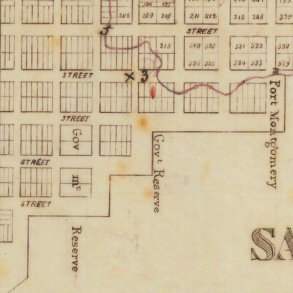
One marked location on the map indicates a “store ship”—a vessel used as a floating warehouse.
Through comparison with archaeological research, including work by maritime historian James Delgado, this location has been identified as the Arkansas.
The Arkansas:
- Sailed from New York to California
- Was damaged and abandoned
- Was repurposed as a warehouse
- Now lies buried beneath modern San Francisco
Overlaying the manuscript map with modern archaeological data confirms the alignment.
A City Beneath the City
Today, remnants of these ships still exist beneath San Francisco’s streets.
One notable site is the Old Ship Saloon, believed to stand directly above the remains of a buried vessel. Excavations and construction work have uncovered artifacts such as:
- Wooden structural elements
- Barrels and storage materials
- Personal and commercial items from the period
These discoveries bring the map’s story into the present—hidden in plain sight beneath the modern city.
Why This Map Matters
This manuscript map captures a fleeting moment in San Francisco’s history: a narrow window when the city was being built, improvised, and transformed in real time.
It is not just a map—it is a narrative document.
Even without its annotations, it would tell the story of a city in motion. With them, it reveals a hidden layer of history beneath the surface.
As Michael Jennings notes, even well-studied maps can still yield new discoveries. Familiar objects often contain overlooked stories—waiting to be uncovered.
Featuring Kevin Brown, Geographicus Rare Antique Maps, and Michael Jennings, Neatline Antique Maps.
Produced by Cory Choy, Tom Fama, and Christian Cucinello.
Sound by Silver Sound.