
CartoCuriosity - Formosa, a propaganda con-job on the Qing.
CartoCuriosity - Formosa, a propaganda con-job on the Qing.
How the Japanese used Persuasive Cartography to take over Taiwan.
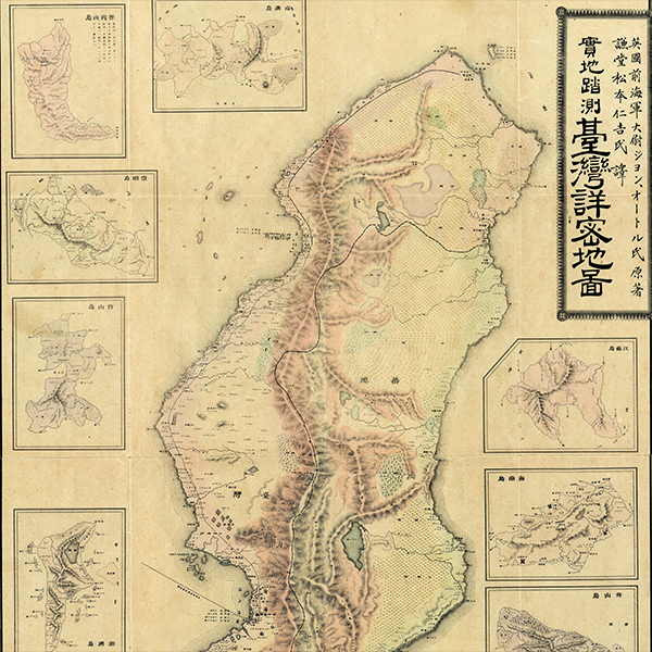
What if a map could justify the conquest of a nation? In 1895, as China and Japan negotiated the end of the First Sino-Japanese War (1894 - 1895), Japanese publisher Nakamura Yoshimatsu issued a remarkable map of Taiwan. Disguised as the work of a British naval officer, it subtly redrew the island to exaggerate vast 'ungoverned' tribal regions and diminish Qing authority. The result was one of the most consequential examples of persuasive cartography, a map that may have helped shape the negotiations leading to Japan's acquisition of Taiwan. Today, we explore the map, the politics behind it, and the extraordinary role cartography played in the transfer of an empire.
Featuring Kevin J. Brown of Geographicus Rare Antique Maps
Produced by Cory Choy and Christian Cuciniello. Edited by Zach Traenor. Music by Luke Allen and El Buru. Sound by Silver Sound
2025-06-13
A Closer Look at the Map

1895 Nakamura Map of Formosa: A Diplomatic Ploy to Take Over Taiwan.
How a Map Helped Japan Seize Taiwan
Join Kevin Brown of Geographicus Rare Antique Maps as he explores one of the most remarkable examples of persuasive cartography ever published: an 1895 Japanese map of Taiwan that may have helped shape the diplomatic negotiations leading to Japan's acquisition of the island.
Recently, a fascinating large-format map arrived in the Geographicus collection. Published in January 1895, just as the First Sino-Japanese War was drawing to a close, the map depicts the island of Formosa, known today as Taiwan. At first glance, it appears to be a detailed survey map of the island. A closer inspection, however, reveals something extraordinary.
Measuring nearly forty inches in height, the map presents Taiwan in a configuration that differs dramatically from its actual geography. The island remains recognizable, but its shape has been subtly manipulated. Along the western side, two large bays cut deeply into the interior, while corresponding projections enlarge the eastern side of the island. The effect is to reduce the apparent size of the populated western lowlands while greatly expanding the mountainous eastern regions.
This was not a cartographic error. It was a deliberate political statement.
The First Sino-Japanese War
By 1895, Japan had spent decades modernizing its military and government along Western lines. During the First Sino-Japanese War (1894–1895), these reforms paid dividends. Japanese forces quickly overwhelmed Qing China, demonstrating the effectiveness of their newly modernized army and navy.
As peace negotiations began, Japanese diplomats insisted that Taiwan be ceded to Japan as part of the settlement. The resulting Treaty of Shimonoseki, signed in April 1895, formally transferred sovereignty over Taiwan from China to Japan.
The map appears to have been produced in anticipation of these negotiations and may have served as a visual argument supporting Japanese claims.
A Cartographic Argument
Running down the center of the map is a dashed line following the crest of Taiwan's central mountain range. This line was not a surveyed political boundary. Instead, it represented the distinction the mapmaker wished to draw between areas administered by the Qing government and regions inhabited by indigenous peoples beyond effective Qing control.
By exaggerating the size of the mountainous eastern regions while minimizing the western plains, the map conveyed a powerful message: Qing authority extended over only a relatively small portion of the island. If much of Taiwan lay outside meaningful Chinese administration, the argument went, how strong was China's claim to sovereignty?
This narrative aligned perfectly with Japanese political objectives. The map suggested that Japan was not seizing a fully governed province but rather assuming responsibility for a largely unadministered territory. In modern terms, it was a sophisticated exercise in persuasive cartography.
The Curious Inset Map
One of the most revealing features appears in the lower-right corner. There, a small inset presents Taiwan in its correct geographic form.
The inclusion of this accurate inset demonstrates that the mapmaker knew the island's true shape. The distortions in the main map were therefore intentional. Rather than reflecting ignorance, they served a political purpose.
The Historical Case for Taiwan
Accompanying the map is an eighteen-page pamphlet. Part gazetteer and part political argument, it discusses Taiwan's resources, trade potential, and strategic value. More importantly, it attempts to construct a historical justification for Japanese control of the island.
The pamphlet begins with the story of Koxinga (Zheng Chenggong), the seventeenth-century warlord who expelled the Dutch from Taiwan and established a Chinese presence on the island. The authors emphasize Koxinga's mixed Japanese and Chinese heritage, presenting this connection as evidence of a historical Japanese relationship with Taiwan.
The second major argument concerns the 1874 Japanese expedition to southern Taiwan. Following the killing of shipwrecked Japanese sailors by indigenous tribes, Japan launched a military campaign against the local inhabitants. The pamphlet portrays this episode as further evidence of Japan's legitimate interest in the island and its affairs.
The Mystery of John Waters
Equally intriguing is the map's attribution. Rather than crediting a Japanese cartographer, the work is supposedly based on the surveys of an Englishman named John Waters or John Walters. There is good reason to believe that no such individual existed.
During the nineteenth century, British cartography enjoyed immense international prestige. Associating the map with an English surveyor lent it an aura of scientific authority and objectivity that a Japanese attribution might not have conveyed to foreign audiences.
The accompanying pamphlet contains an introduction supposedly written by this Englishman. The text is nominally in English but reads in a fascinating hybrid style characteristic of late nineteenth-century Japan, when English language instruction was still developing. Although often difficult to understand, the text combines English vocabulary, Japanese transliterations, unconventional grammar, and unusual typesetting practices into a remarkable linguistic artifact.
Curiously, the Japanese version of the same text identifies the mysterious Mr. Waters not as a military officer but as a missionary, further raising questions about his existence.
A Legacy That Endures
Taiwan remained under Japanese rule until 1945. Yet the issues raised by this map continue to resonate today.
Taiwan exists in a uniquely complex political position. It functions as a self-governing democratic state with its own institutions, military, and economy, while simultaneously being claimed by the People's Republic of China. More than a century after this map was published, questions of sovereignty, legitimacy, and political geography remain at the center of international debate.
What makes this map so remarkable is not merely its rarity or size, but the way it demonstrates the power of cartography itself. Maps do more than record geography. They shape perceptions, influence policy, and, in some cases, help determine the course of history.