
CartoCuriosity: Jeffersonian States. Metropotamia?
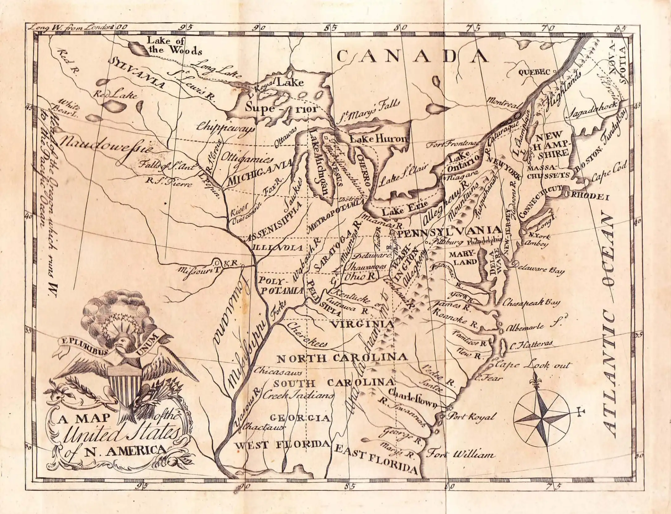
CartoCuriosity: Jeffersonian States. Metropotamia?
Illinoia, Michigania, Saratoga, Washingon, Chersonesus, Sylvania, Assenisipia, Metropotamia, Polypotamia, and Pelisipia
Featuring Kevin Brown, Geographicus Rare Antique Maps & Michael Buehler, Boston Rare Maps.
Produced by Cory Choy and Christian Cucinello.
Edited by Yoni Cohen
Music by L. Budu and Luke Allen. Sound by Silver Sound.
2026-10-22
A Closer Look at the Maps
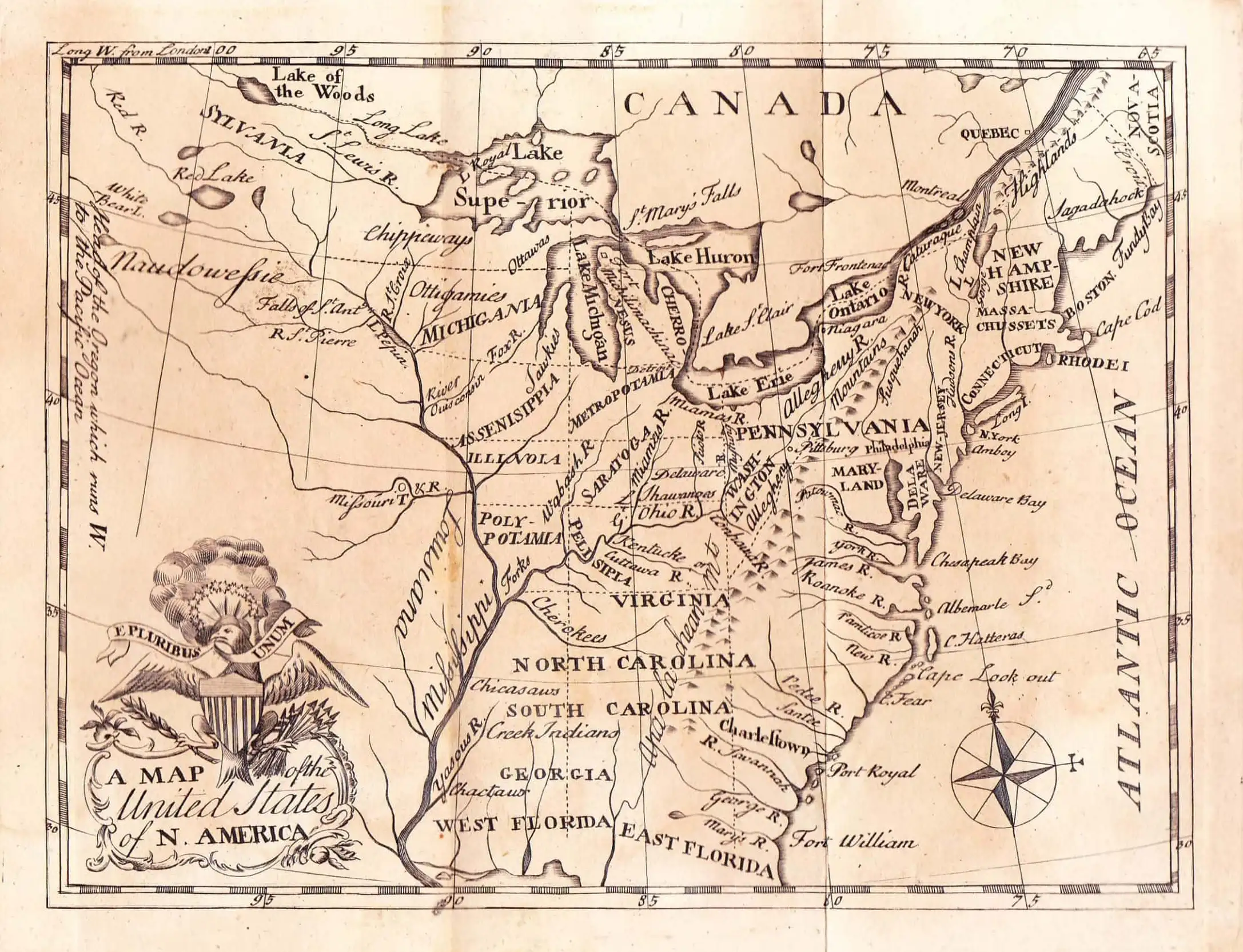
One of only two published maps to give Jefferson’s proposed state names in the Old Northwest.
The States That Might Have Been: Jefferson’s Plan for the American West
In this episode of CartoCuriosity, Kevin Brown of Geographicus Rare Antique Maps speaks with Michael Buehler of Boston Rare Maps about Thomas Jefferson’s proposed western states, the Ordinance of 1784, and the Northwest Ordinance of 1787. Their conversation explores how an ambitious plan for territorial expansion helped shape the young republic—and why the map of the United States could have looked very different.
A New Nation, an Unsettled West
The Treaty of Paris of 1783 did more than bring the Revolutionary War to a close. Great Britain recognized American independence, and the treaty established boundaries for the United States extending west to the Mississippi River.
For the new republic, this vast western territory presented both extraordinary possibilities and immediate problems. The United States was nearly bankrupt. Selling western land promised revenue, while settlement offered an opportunity to extend republican institutions beyond the Appalachians.
Yet the territory was neither empty nor free of competing claims. Indigenous peoples inhabited the region, and settlers moving west on their own initiative came into conflict with Native communities and with one another.
As Buehler explains, western expansion confronted the government with interlocking opportunities and crises. Acquiring territory on a treaty map was only the beginning. Determining how that territory would be governed was another matter entirely.
Who Controlled the Land?
Even within the United States, authority over the West remained unsettled.
Several of the original states asserted western claims extending to the Mississippi. The international boundaries recognized in the Treaty of Paris therefore did not automatically give Congress uncontested control over the land within them.
A significant development came on March 1, 1784, when Virginia ceded its extensive western claims. That same day, Jefferson put forward a preliminary plan for organizing western territory into prospective states.
The proposal addressed a fundamental question: would western settlements remain subordinate possessions, or could they eventually become equal members of the Union?
Jefferson’s Ten Proposed States
Jefferson’s preliminary plan envisioned ten prospective states that would develop politically and eventually enter the Union.
Their boundaries reveal a striking preference for geometric order. The scheme relied heavily on lines of latitude and longitude, dividing territory into bands at two-degree intervals and arranging the proposed states in three north–south tiers.
One dividing meridian ran through the falls of the Ohio, near present-day Louisville. Another passed through the confluence of the Kanawha and Ohio rivers. The Mississippi, Ohio, and Lake Erie also helped define the arrangement.
Natural features thus supplied reference points, but much of the proposed internal geography followed an abstract grid. To Buehler, this was characteristically Jeffersonian: a preference for symmetry and tidiness over the complexities of conditions on the ground.
Brown raises the possibility that ten new states might have been intended to form a political counterweight to the original thirteen. Buehler is cautious. Although politics mattered, he does not see Jefferson’s proposal at this stage as an effort to create a particular voting bloc.
From Proposal to the Ordinance of 1784
Jefferson’s preliminary scheme and the enacted Ordinance of 1784 were not identical.
Congress adopted the ordinance in April 1784 with substantial changes. Buehler points to an especially puzzling feature: in his reading, the final boundaries appeared to provide for only eight or nine states, rather than the original ten.
As he recalls it, the boundary provisions extended only to the 45th parallel, leaving a large northern area unaccounted for. On the Purcell map discussed in the interview, this region appears as Sylvania.
The larger objective remained a process of state formation as western land was sold and settled. The ordinance offered a framework through which new communities could organize governments and ultimately join the Union.
Who Should Build a State?
The 1784 ordinance envisioned a comparatively grassroots approach to political organization. Settlers would assemble, determine their form of government, write constitutions, and elect leaders.
That approach quickly encountered opposition.
Buehler describes a deep anxiety within Congress about entrusting the creation of governments to frontier farmers. The disagreement concerned more than administrative procedure. It exposed a tension between republican self-government and the political leadership’s distrust of the people who would exercise it.
Could settlers be trusted to establish stable governments themselves, or should Congress supervise their political development?
A West Looking Beyond the Atlantic States
Geography supplied another reason for concern.
The original thirteen states faced the Atlantic. The proposed western states had different connections: toward Canada in the north and, through the Ohio and Mississippi river systems, toward New Orleans.
These routes could shape commerce, culture, and political loyalties. Members of Congress worried that western communities might develop orientations substantially different from those of the eastern states.
The challenge was therefore not simply to draw boundaries. It was to create a durable political union among regions whose economic connections might pull them in different directions.
The Northwest Ordinance of 1787
In July 1787, Congress superseded the 1784 ordinance with the Northwest Ordinance.
These were distinct measures. Jefferson’s earlier proposal, the ordinance enacted in 1784, and the Northwest Ordinance of 1787 represented different stages in the effort to organize the West.
For Buehler’s argument, the 1787 measure made two crucial changes.
First, it established a more centrally directed process of territorial government. Congress would guide the early stages, with greater self-government and eventual statehood following as territories developed.
Second, it provided for at least three and no more than five states in the territory northwest of the Ohio, replacing the earlier conception of numerous smaller states.
The goal of eventual membership in the Union survived, but the route toward it became more firmly controlled from above.
Expanding Congressional Power
Brown observes a paradox: a Congress often described as weak under the Articles of Confederation was establishing a system that could enlarge national authority over time.
Buehler agrees. He argues that the Articles did not empower Congress to create new states, making its assumption of that role an extraordinary assertion of authority. He describes it as an “enormous power grab.”
The power to organize and admit new states would also become part of the constitutional system that followed.
In Buehler’s interpretation, the Northwest Ordinance thus combined a national expansion of power with a process whose initial stages were distinctly undemocratic. Western settlers would not immediately enjoy the political autonomy anticipated in the earlier approach.
Equal States, Rather Than Permanent Dependencies
Yet Buehler also sees a deeply republican purpose in both ordinances.
Congress could have treated western territories as permanently subordinate possessions. Instead, it chose a framework in which they could ultimately enter the Union on equal terms with the original states.
This is the particular sense in which Buehler describes Congress as rejecting an imperial model: new political communities would have a path out of territorial dependence and into equal statehood. That argument concerns their relationship to the existing states; the interview also makes clear that western settlement involved conflict with Indigenous inhabitants.
Central direction and eventual political equality existed within the same system. For Buehler, that combination helps explain the Northwest Ordinance’s importance to the young republic’s success.
Reading the Map as a Contingent History
The proposed Jeffersonian states offer a reminder that familiar boundaries were never inevitable.
A modern map can make the United States appear settled and self-evident, as though its divisions arose naturally from the landscape. The history of these ordinances reveals a different process: proposals revised, political fears negotiated, and competing ideas about government translated into lines on paper.
“Boundaries are always the result of highly imperfect, highly messy and highly contingent processes.”
— Michael Buehler
Jefferson’s ten proposed states did not become the map Americans know today. Their significance lies partly in showing an alternative that was once possible—and in illuminating the choices through which another arrangement emerged.
Looking at a map of the United States, Buehler suggests, should prompt a historical question: how did it come to look this way, when it could have looked so different?
Adapted from a CartoCuriosity interview hosted by Kevin Brown of Geographicus Rare Antique Maps, featuring Michael Buehler, founder of Boston Rare Maps.
Featuring Kevin Brown, Geographicus Rare Antique Maps & Michael Buehler, Boston Rare Maps.
Produced by Cory Choy and Christian Cucinello.
Edited by Yoni Cohen
Music by L. Budu and Luke Allen. Sound by Silver Sound.