
CartoCuriosity - Royal Siamese Maps
CartoCuriosity - Royal Siamese Maps
Challenging long-held assumptions about Siamese cartography - or lack thereof.
In this episode of CartoCuriosity, Kevin Brown of Geographicus Rare Antique Maps explores one of the most remarkable discoveries in Southeast Asian cartography: a rare hand-painted Siamese textile map that may predate the famed Royal Siamese Maps. Long believed to lack an indigenous mapping tradition, Siam (Thailand) is revealed to have produced sophisticated geographic documents blending Thai, Chinese, and regional cartographic concepts. Acquired from an obscure antique shop and ultimately placed with the Library of Congress, this extraordinary map offers new insight into the history of Thai cartography, the reign of Rama I, and the evolution of mapping in Southeast Asia.
Featuring Kevin Brown, Geographicus Rare Antique Maps.
Produced by Cory Choy, Tom Fama, and Christian Cucinello.
Music by L. Budu and Luke Allen. Sound by Silver Sound.
2025-11-11
A Closer Look at the Maps

The only indigenous Siamese map outside of Siam.
Podcast Summary
A rare discovery from a cartographic tradition that almost never was
In this episode of CartoCuriosity, Kevin Brown of Geographicus Rare Antique Maps explores a rare hand-painted Siamese textile map that challenges long-held assumptions about Thai cartography and may represent a previously unknown precursor to the famed Royal Siamese Maps.
In the antiquarian map trade, truly unique discoveries are rare. Occasionally, however, an object appears that challenges not only what we know, but what we assume is possible. Such was the case with a large textile map from Siam, a region long believed to have had little or no indigenous cartographic tradition in the Western sense.
A Different Way of Seeing Territory
A well-known anecdote in Southeast Asian cartographic history tells of a Western visitor asking the King of Siam for a map showing his borders. The King's response is said to have been simple:
"Why would I need such a thing?"
Unlike the European model, defined by fixed borders and territorial precision, Southeast Asian polities often operated through spheres of influence. Authority extended outward through tribute relationships rather than rigid lines on a map.
In this system, a town might identify as Siamese, Burmese, or Khmer depending on political allegiance, and in some border regions, multiple allegiances could coexist simultaneously.
An Unexpected Discovery
A few years ago, Brown encountered something unusual while visiting an antique shop specializing in Asian objects. Hanging on the wall was a large textile with what appeared to be cartographic elements.
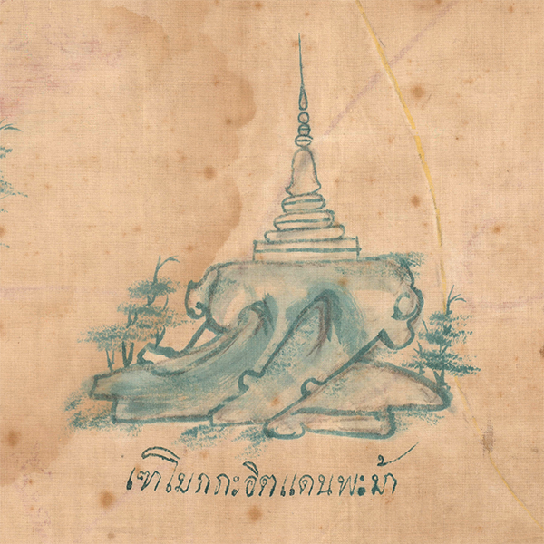
Upon closer inspection, it revealed itself as something far more intriguing: a large hand-painted textile, covered in Thai script, yet lacking the scale and structure normally associated with Western cartography.
Rather than a map in the European sense, it resembled an itinerarium, a route-based spatial narrative similar in concept to the ancient Roman Peutinger Map. Recognizing its potential significance, Brown acquired the piece and began the process of research and analysis.
A Missing Cartographic Tradition?
The map presented a puzzle. It was clearly Thai, yet Thailand, historically Siam, was not widely known for producing maps in the Western cartographic tradition.
That assumption began to change only recently, when 17 large, hand-painted maps were discovered in Bangkok's Grand Palace. Created on hand-spun cloth and stored unnoticed for over a century, these works are now known as the Royal Siamese Maps.
The Royal Siamese Maps were briefly displayed at the Jim Thompson House Museum before being returned to royal collections. They have since been digitized and documented in a single publication, but remain largely inaccessible to scholars.
Connecting the Dots
The textile discovered in the antique shop shared striking similarities with the Royal Siamese Maps, including identical material, a similar artistic and cartographic style, and nearly identical handwriting.
There were, however, important differences. The newly discovered map featured two maps on opposite sides, drawn in different colors, and included visible corrections and revisions.
These details suggested that the textile was likely a working draft, an intermediary stage in the creation of the Royal Siamese Maps.
Chinese Influence
The cartographic style reflects strong Chinese influence. Water is depicted as flowing, wavy networks, scale is largely absent, and space is organized through routes and relationships rather than measured distance.
These characteristics align with broader East Asian mapping traditions, which often emphasized relational geography over precise measurement.
A Map of Conflict and Expansion
The maps depict regions critical to Siamese interests in the late 18th century, including the Burmese-Siamese frontier and territories east of Bangkok toward Cambodia and Vietnam.
This context aligns with the reign of Rama I (1782-1809), who expanded Siamese influence during a period of regional instability. Cambodia, caught between Siamese and Vietnamese pressures, entered into a protective relationship with Siam, making detailed geographic knowledge strategically important.
Why Maps, and Why Then?
If Siam historically had little need for maps in the European sense, why did such works emerge at this moment? The answer lies in changing historical conditions: increasing European influence, exposure to Western cartographic techniques, and the military and administrative needs of the early Bangkok period.
The founding of Bangkok as a capital, strategically located and fortified using European methods, also played a role. In this context, maps became tools not merely of knowledge, but of governance, strategy, and control.
From Discovery to Preservation
After extensive research and documentation, the map was offered for sale and ultimately acquired by the Library of Congress.
Scholars specializing in Southeast Asia have reviewed the piece and agree that it likely predates the Royal Siamese Maps and represents a preparatory working draft.
An Open Field for Research
Despite this discovery, Thai cartography remains under-explored. The Royal Siamese Maps are not publicly displayed, and scholarly work remains limited. This newly discovered example may therefore represent one of the most accessible artifacts for further study.
For historians and linguists, particularly those able to read historical Thai, the map presents a rare and compelling opportunity to better understand the history of mapping in Siam and Southeast Asia.
Featuring Kevin Brown, Geographicus Rare Antique Maps.
Produced by Cory Choy, Tom Fama, and Christian Cucinello.
Music by L. Budu and Luke Allen. Sound by Silver Sound.