
CartoCuriosity - The Peutinger Table, an Ancient Roman Map
CartoCuriosity - The Peutinger Table, an Ancient Roman Map
How Ancient Romans conceived of and navigated their expansive empire.
In this episode of CartoCuriosity, Kevin Brown of Geographicus Rare Antique Maps explores the Peutinger Table, or Tabula Peutingeriana - an extraordinary 12-foot-long Roman road map that reveals how the ancient world understood geography, travel, and imperial infrastructure. Stretching from Britain across Europe, the Mediterranean, Persia, and India, this remarkable itinerary sacrifices geographic accuracy to trace the roads, cities, ports, and staging posts that connected the Roman Empire. From its possible origins in the monumental map of Marcus Vipsanius Agrippa to its survival as a medieval vellum manuscript and later publication by Abraham Ortelius and Jan Jansson, the Peutinger Table offers an unparalleled window into Roman cartography and a radically different way of seeing the ancient world.
Featuring Kevin Brown of Geographicus Rare Antique Maps
Produced by Cory Choy, Tom Fama, and Christian Cuciniello
Music by Luke Allen and El Buru. Sound by Silver Sound
2026-09-01
A Closer Look at the Maps
How space, travel, and imperial infrastructure were conceptualized in Antiquity.
The Roman world as a network of roads
In this episode of CartoCuriosity, Kevin Brown of Geographicus Rare Antique Maps explores the Peutinger Table, an extraordinary twelve-foot Roman itinerary that reveals how travelers in antiquity understood distance, movement, and the vast infrastructure connecting the Roman Empire.
What Is the Peutinger Table?
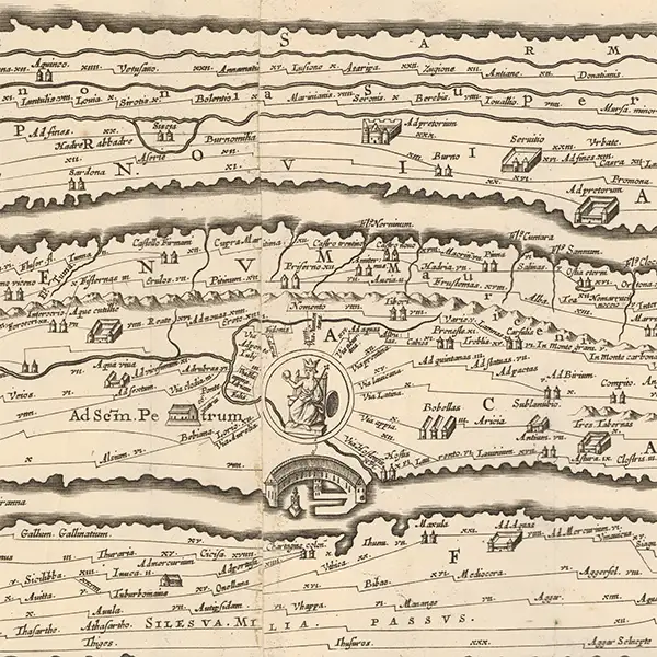
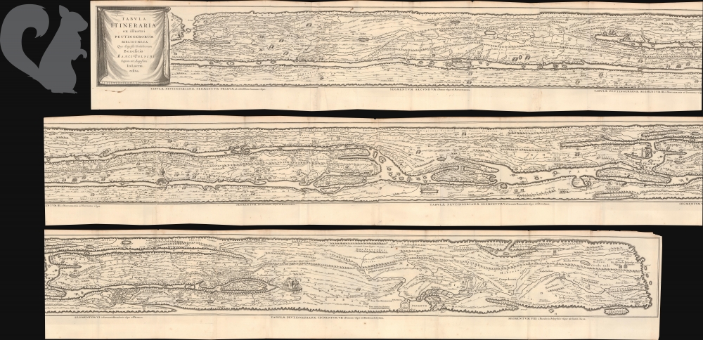
The Peutinger Table—also known as the Tabula Peutingeriana—is an exceptionally long and narrow map measuring roughly 12 feet in length but only 7–8 inches in height.
It depicts the road network of the ancient Roman world, extending from Britain and the Iberian Peninsula in the west through the Mediterranean, Persia, and India in the east.
As the only surviving map of its kind derived from Roman antiquity, the Peutinger Table offers a remarkable view of how the Romans conceptualized travel across their empire.
An Itinerary, Not a Conventional Map
The Peutinger Table is not a map in the modern geographic sense.
It is an itinerarium—a route-based diagram designed to show connections, stopping places, and distances between destinations.
Its geography is deliberately distorted:
- Important regions such as Italy are dramatically enlarged
- Distant or less familiar territories are compressed and abstracted
- Roads and distances are emphasized over geographic scale
- Cities and way stations are arranged according to travel routes
A useful modern comparison is a subway map. Neither is geographically precise, but both are exceptionally effective at explaining how to move through a complex transportation network.
The Peutinger Table is less concerned with where places are than with how to travel between them.
Mapping Movement Through the Roman Empire
The map presents the Roman world not as a collection of political borders, but as an interconnected system of roads, cities, ports, staging posts, spas, temples, and administrative centers.
Thousands of place names appear along colored route lines, often accompanied by distances indicating the length of each stage of a journey.
Major cities receive distinctive pictorial treatment. Rome, Constantinople, and Antioch are especially prominent, reflecting their political, commercial, and symbolic importance.
The result is a practical visualization of imperial infrastructure: a world held together by roads and the movement of soldiers, officials, merchants, messengers, pilgrims, and travelers.
Roman Origins
The Peutinger Table’s distant origins may reach back to the first century BCE and the great public map associated with the Roman general and statesman Marcus Vipsanius Agrippa.
Displayed in Rome after Agrippa’s death, that monumental work offered Roman citizens a visual representation of lands and routes extending across the known world.
Although the relationship cannot be reconstructed with certainty, the surviving Peutinger Table appears to preserve information accumulated through successive Roman maps and itineraries.
Survival Through Copying
No original Roman version of the Peutinger Table survives.
The artifact known today is a medieval manuscript copy, probably produced during the twelfth or early thirteenth century from earlier prototypes that had been revised repeatedly over time.
Its contents preserve several chronological layers. The appearance of Constantinople and the prominence of Ravenna, for example, point to revisions made during late antiquity.
The map was drawn on sheets of vellum—specially prepared animal skin—joined together to create its extraordinary elongated format. The durability of this material helped it survive centuries of handling, storage, and movement.
Rediscovery During the Renaissance
The manuscript reentered European scholarly consciousness during the Renaissance, when the German humanist Conrad Celtis acquired it, possibly while working under the patronage of Holy Roman Emperor Maximilian I.
Maximilian sought to associate his empire with the authority and grandeur of ancient Rome. A document illustrating the roads and cities of the Roman world held obvious political as well as scholarly significance.
Celtis eventually entrusted the manuscript to the Augsburg humanist, antiquarian, and statesman Konrad Peutinger. Although Peutinger did not create the map, his ownership became permanently attached to it, giving rise to the modern names Peutinger Table and Tabula Peutingeriana.
From Manuscript to Printed Map
The Peutinger Table became more widely known through the efforts of Renaissance scholars and publishers who sought to reproduce the manuscript in print.
Among the most important was Abraham Ortelius, creator of the first modern atlas. Ortelius prepared an engraved edition that transformed the unique medieval manuscript into a work capable of circulating among scholars and collectors throughout Europe.
The map’s unusual proportions posed a considerable technical challenge. Because early copperplates were much smaller than the continuous vellum original, engravers divided the route map into sections and rearranged it for publication.
Later cartographers and publishers, including Jan Jansson, issued expanded versions that restored more of the Peutinger Table’s sweeping horizontal character.
Reading a Distorted World
To modern eyes, the Peutinger Table can appear almost incomprehensible. Seas become narrow ribbons, continents are compressed into horizontal bands, and north and south matter far less than east and west.
Yet this apparent distortion is precisely what makes the map successful.
Its purpose was not to reproduce the physical shape of the earth. It was to organize travel information across an immense network in a format that could be read sequentially.
The Peutinger Table therefore demonstrates that cartographic accuracy depends upon purpose. A map intended to explain routes may sacrifice geographic shape while remaining exceptionally accurate as a guide to movement.
A Rare Survival
The original medieval vellum manuscript survives in the Austrian National Library in Vienna.
One section depicting the westernmost part of the Roman world—including much of Britain and the Iberian Peninsula—has been lost, but the surviving sheets remain among the most important cartographic artifacts inherited from antiquity.
Through them, historians can study Roman roads, ancient place names, administrative centers, transportation infrastructure, and the changing geographic knowledge of the late Roman and medieval worlds.
Recovering the Knowledge of Antiquity
The Renaissance scholars who preserved and published the Peutinger Table did not necessarily believe themselves more knowledgeable than the ancients.
Many instead understood history as a process of intellectual decline in which the achievements of Greece and Rome had been fragmented, forgotten, or lost.
Recovering an ancient geographic document was therefore more than an antiquarian exercise. It represented the restoration of knowledge and the renewal of a perceived connection with the classical past.
The Peutinger Table was not merely a guide to ancient travel—it was a route back into antiquity itself.
Why the Peutinger Table Matters
The Peutinger Table is more than an ancient map. It is a record of how the Roman world functioned.
It presents an empire defined not primarily by borders, but by roads, distances, cities, and movement. It reveals a conception of space shaped by the practical experience of traveling from one destination to the next.
Despite the disappearance of countless other Roman maps, this singular survival continues to influence our understanding of ancient geography, imperial infrastructure, and the history of cartographic thought.
Featuring Kevin Brown, Geographicus Rare Antique Maps.
Produced by Cory Choy, Tom Fama, and Christian Cucinello.
Music by L. Budu and Luke Allen. Sound by Silver Sound.