Digital Image: 1858 Chace Wall Map of Hillsboro County, New Hampshire (Nashua, Manchester)
HillsboroCounty-chase-1858_d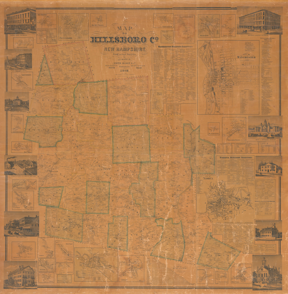


Title
Map of Hillsboro Co. New Hampshire From Actual Surveys.
1858 (dated) 60 x 60 in (152.4 x 152.4 cm) 1 : 51000
1858 (dated) 60 x 60 in (152.4 x 152.4 cm) 1 : 51000
Description
FOR THE ORIGINAL ANTIQUE MAP, WITH HISTORICAL ANALYSIS, CLICK HERE.
Digital Map Information
Geographicus maintains an archive of high-resolution rare map scans. We scan our maps at 300 DPI or higher, with newer images being 600 DPI, (either TIFF or JPEG, depending on when the scan was done) which is most cases in suitable for enlargement and printing.
Delivery
Once you purchase our digital scan service, you will receive a download link via email - usually within seconds. Digital orders are delivered as ZIP files, an industry standard file compression protocol that any computer should be able to unpack. Some of our files are very large, and can take some time to download. Most files are saved into your computer's 'Downloads' folder. All delivery is electronic. No physical product is shipped.
Credit and Scope of Use
You can use your digial image any way you want! Our digital images are unrestricted by copyright and can be used, modified, and published freely. The textual description that accompanies the original antique map is not included in the sale of digital images and remains protected by copyright. That said, we put significant care and effort into scanning and editing these maps, and we’d appreciate a credit when possible. Should you wish to credit us, please use the following credit line:
Courtesy of Geographicus Rare Antique Maps (https://www.geographicus.com).
How Large Can I Print?
In general, at 300 DPI, you should at least be able to double the size of the actual image, more so with our 600 DPI images. So, if the original was 10 x 12 inches, you can print at 20 x 24 inches, without quality loss. If your display requirements can accommodate some loss in image quality, you can make it even larger. That being said, no quality of scan will allow you to blow up at 10 x 12 inch map to wall size without significant quality loss. For more information, it is best consult a printer or reprographics specialist.
Refunds
If the high resolution image you ordered is unavailable, we will fully refund your purchase. Otherwise, digital images scans are a service, not a tangible product, and cannot be returned or refunded once the download link is used.
Cartographer S
Jacob Chace Jr. (January 27, 1819 - February 18, 1903) was an American surveyor, civil engineer, educator, and map publisher. Born in North Hoosick, New York, Chace became one of the most prolific creators and publishers of county maps of the northeastern United States in the mid-19th century. He was involved in the production of large-format county maps, published mostly between 1854 and 1860. Many of these counties were in Maine, but he also produced maps of Vermont, New Hampshire, and New York. There is some ambiguity in historical accounts of his date of death. Many references state that he died in 1864 while Ambrose F. Church was working for him to create a map of Nova Scotia. However, references to a Jacob Chace surveying towns for maps of Virginia and North Carolina appear in newspaper columns in the 1870s and 1880s. Chace's name is sometimes misspelled on maps and references as 'Chase'. Our own research confirms that Chase died in Omaha, Nebraska, on February 18, 1903. More by this mapmaker...
Smith, Mason, and Company (fl. 1850 - 1865) was a map publishing firm with offices in several cities, including New York, Boston, Philadelphia, Troy, and Manchester, NH. They published numerous county wall maps, mostly focusing on New England, through the second half of the 19th century. The plethora of offices and addresses on their imprints suggests a large business, but the reality may be that most of these were little more than addresses and short-term annexes established to promote and sell individual maps. The firm was operated by Horace Mason, but due to the commonality of this name, we have had some difficulty identifying him. Smith likely refers to 'H. and C.T. Smith', prominent map publishers in their own right. There are papers associated with Smith, Mason, and Company preserved at the Library of Congress, which remain undigitized but which may illuminate this firm. Learn More...
References
Cobb, D., New Hampshire Maps to 1900: An Annotated Checklist, #3, #245. Phillips (America), p. 318. Boston Public Library, Leventhal Center, G3743.H4 1858.C5.