
Porcineograph: One Nation Under Hog
Porcineograph: One Nation Under Hog
Perhaps the greatest pig map ever made!
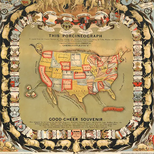
Discover William Emerson Baker’s extraordinary Porcineograph, an 1875 pictorial map that transforms the United States into a pig, complete with a Maine snout, an Alaska tail, and Cuba as a sausage. In this episode of CartoCuriosity, Kevin Brown of Geographicus Rare Antique Maps explores how this colorful chromolithograph became a lavish party favor promoting Baker’s sanitary piggery and the Pure Food Movement. Packed with regional pork dishes, Reconstruction-era politics, and hints of territorial expansion, this rare antique map offers a wonderfully eccentric window into American food history, social reform, and the art of "ge'hog'raphy."
Featuring Kevin Brown of Geographicus Rare Antique Maps
Produced by Cory Choy, Tom Fama, and Christian Cuciniello
Music by Luke Allen and El Buru. Sound by Silver Sound
2026-09-25
A Closer Look at the Maps
Considered the Holy Grail of Ge'hog'raphy.
One Nation Under Hog
William Emerson Baker’s Porcineograph: A Ge’hog’raphy of the United States
In this episode of CartoCuriosity, Kevin Brown of Geographicus Rare Antique Maps explores William Emerson Baker’s Porcineograph, a colorful map of the United States as a pig, created as a party favor to promote an eccentric millionaire’s sanitary piggery.
A Map Worth Waiting For
This is Kevin Brown with Geographicus Rare Antique Maps and CartoCuriosity. Today we’re presenting William Emerson Baker’s Porcineograph, one of the greatest and earliest American pictorial images, and the greatest piece of ge’hog’raphy ever issued.
I first encountered the Porcineograph in another dealer’s home, and I thought, “That is a great map.” I wanted one for many, many years before I was finally able to acquire one. I would say it was maybe a ten-year saga. And then I had it for all of one week before it moved on to a client.
The United States as a Pig
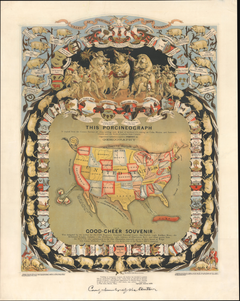
The Porcineograph is essentially a party favor. It’s a broadside poster of sorts, issued in 1875, measuring about 23 by 17 inches. It’s a chromolithograph, a form of color printing popular in the late nineteenth century that produces extremely vivid, rich color.
It is one of the earliest examples of American pictorial cartography, if not the earliest I can think of. And it is a map of the United States as a pig.
The snout is Maine, and the tail reaches out to become Alaska. All four feet are depicted: one is Florida, one is Baja California, and the other two are more symbolic. One reaches toward Hawaii; the other is like a channel leading toward Cuba, which is represented as a sausage.
Around the map are symbols of the various states and territories, along with their favorite pork dishes. There are some we recognize today, like pork and beans. Then there are some really weird ones that don’t sound very appetizing. Alaska Territory, for example, has a favorite pork dish involving seal, blubber, and pork.
William Emerson Baker: A Man of Many Causes
This was made by an eccentric millionaire named William Emerson Baker. Baker did, in fact, love pigs. The map was an expression of the importance and value of the pig, rather than anything negative or derogatory. In fact, Baker himself did not eat pigs, although he didn’t prevent others from eating them.
A little background on Baker: he wasn’t well educated, but he was always coming up with new ideas. He had a humanitarian streak. His creed was faith, hope, and charity. He was hopeful for the future of the United States in particular, and he believed that the path forward was for people of wealth, like him, to become involved in public charities. He was, by all measures, a good guy.
He was also extremely rich, a kind of Rockefeller-esque industrialist. He made his fortune as a partner in the Grover and Baker Sewing Machine Company, the first company in the United States to industrialize the manufacture and sale of the sewing machine. He sold his sewing machine business in 1868.
Baker was one of the founders of MIT, or what would become MIT. He built Boston’s natural history museum, which eventually became the Museum of Science, and numerous other institutions associated with his values.
Urban Pigs and the Pure Food Movement
Around this time, the industrialization of the American city had a lot of side effects that concerned Baker. Farmers were moving into cities for factory work, and they brought with them this concept of urban farming.
Pigs did very well in an urban setting. They could eat practically anything, and the easiest way to feed a pig was simply to let it go about its business and eat whatever it found. But in a very dirty industrial city, that meant human waste, industrial waste, and any kind of sludge or filth lying around. The pig would eat it, and then people would grab the pig, slaughter it, and eat it.
In response to these unsanitary conditions, Baker became involved in the Pure Food Movement, which is exactly what it sounds like: the idea that food should be clean, that pigs and other animals should be given good food, and that this would produce a more delicious and much more healthful food product.
The Sanitary Piggery
Baker’s focus became this idea of a sanitary piggery, and he took it to the extreme. His pigs were given little pillows and silk blankets. The piggery was extremely luxurious. Think of it as the Kobe beef of pigs.
To launch the piggery, he wanted to promote the idea to Boston society. And to do that, he had a massive party. He invited 2,500 people and prepared the Porcineograph as a party favor to promote his newest humanitarian movement.
Guests were encouraged to submit, in his words, “a brain effusion in terse prose or rhyme pertaining to the hog.” They were to submit this several months before the party and were expected to recite it during the event. They were also expected to sing porcine songs, accompanied by a hired quartet. It must have been quite the event.
Each guest received a Porcineograph: this beautifully designed chromolithograph broadside showing the United States as a pig, or, as Baker calls it, a ge’hog’raphy of the United States.
Reconciliation After the Civil War
One of the most interesting things about this map is that it is literally packed with Easter eggs, if you will. There are little statements about Baker’s social views, his political views, and his ambitions for himself and for the country. He was a man of many causes, so this map is about much more than his piggery.
We’re in the middle of Reconstruction, and he’s thinking about reconciliation between the North and South. The map lists Southern military units that fought for the Confederacy in the Civil War, which he invited to the party in an effort to rebuild relations and unify the country as a whole.
A Pig with Territorial Ambitions
It appears that Baker also had some colonial aspirations for the United States. In the north, the pig’s fur is starting to bristle toward Canada, which is called the “New Dominion.” We can infer that he’s suggesting the United States perhaps expand northward toward Canada.
There is also some very interesting language in and around Mexico, including biblical references and an area called the “Free Zone.” This is really talking about the porous border between Mexico and Arizona, New Mexico, and Texas. The suggestion seems to be that Mexico should watch its P’s and Q’s with regard to the United States.
There’s an interesting commentary in the titling, too, suggesting that some of these changes would not create a perfect ge’hog’raphy short of congressional legislation. So it seems that Baker is calling for some territorial expansion on the part of the United States.
A Lavish Gift and a Rare Survival
The Porcineograph became extremely popular. Each of the 2,500 guests received one. This would have been a wildly generous gift, something valued by whoever received it, and something that only a wealthy multimillionaire like Baker could have produced and given out on such a lavish scale.
A year later, he issued another version, with minor changes to the typography, that the public could buy. Given that there were probably at least 5,000 made, it’s shocking how rare they are today.
Featuring Kevin Brown, Geographicus Rare Antique Maps.
Produced by Cory Choy and Christian Cucinello.
Music by L. Budu and Luke Allen. Sound by Silver Sound.