1870 Murray Map of the Afar Country, Eritrea and Ethiopia
AfarCountry-murray-1870$200.00

Title
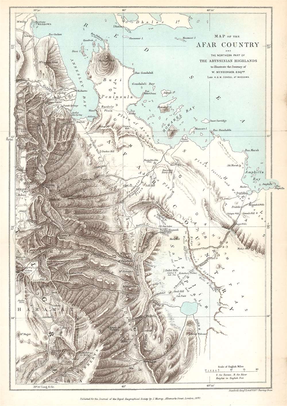
Map of the Afar Country and the Northern Part of the Abyssinian Highlands to illustrate the Journey of W. Munzinger Esqure. Late H.B.M. Consul at Massowa.
1870 (dated) 11.5 x 8 in (29.21 x 20.32 cm) 1 : 844400
1870 (dated) 11.5 x 8 in (29.21 x 20.32 cm) 1 : 844400
Description
This is an 1870 John Murray map of the Afar Country, comprising parts of modern-day Eritrea and Ethiopia. The map was created to accompany a The Journal of the Royal Geographical Society paper by Werner Munzinger. Dashed tracks follow Munzinger's groundbreaking exploration of the little known region.
Munzinger's Travels
Munzinger's peregrinations began at Amphilla and proceeded south through the Afar Country and across the Asali Salt Plain to Ala in the Desso Mountains. Munzinger and his companions then retraced their steps through the Desso Mountains before turning north along the foothills. They stopped in Misse on the Buri Peninsula along Annesley Bay, continued around the bottom of the bay, and then north to Massowa, their final destination. The map notes important geographic locations, particularly hills, wells, and settlements. Along the edge of the Salt Plain, wells and palm trees - indicators of water - are noted.Werner Munzinger
Werner Munzinger (April 4, 1832 - November 14, 1875) was a Swiss administrator and explorer in the Horn of Africa. Born in Olten, Switzerland, Munzinger attended the University of Bern, Munich University, and the Sorbonne before moving to Cairo in 1852. After a year mastering Arabic, Munzinger entered a French mercantile house and participated in trading expeditions to the Red Sea. In 1865, he became the manager of the British Massawa consulate on the Ethiopian border, but, after the 1868 British invasion of Ethiopia, he remained in Massawa and became the French consul. In July 1870, after a failed attempt to broker the French annexation of Massawa, Munzinger left French service to explore the southern Arabian Peninsula. Not long after, he became the governor of the Keren region and Massawa, this time in service to the Egyptian government. Ultimatley, Minzinger was killed in battle during the 1875 Egyptian attack on Ethiopia.Publication History and Census
This map was created by John Murray and published in The Journal of the Royal Geographical Society in 1870. Scarce to the market and as a separate map poorly represented institutionally.CartographerS
John Murray I (1737 - 1793) founded the British publishing firm John Murray (1768 - present) in London. Born in Edinburgh, Murray served as an officer in the Royal Marines and built a list of authors that included Isaac D’Israeli and published the English Review. Murray the elder also was one of the founding sponsors of the London evening newspaper The Star in 1788. John Murray II (November 27 1778 - June 27, 1843) continued the family publishing business and developed it into one of the most important and influential publishing houses in Britain. The list of authors published by the firm grew to include Jane Austen, Sir Walter Scott, Washington Irving, George Crabbe, and Lord Byron under his tenure. Murray II also moved the business to 50 Albermarle Street in Mayfair, which became famous for Murray’s tradition of ‘four o’clock friends’, which was afternoon tea with his writers. John Murray III (1808 - 1892) continued to grow the business, and the firm published the first English translation of Goethe’s Theory of Colours, David Livingstone’s Missionary Travels and Charles Darwin’s Origin of Species during his tenure. Murray also published Herman Melville’s first two books. The firm began publishing Murray Handbooks in 1836, an ancestor of all modern travel guides. Sir John Murray IV (1851 - 1928) was publisher to Queen Victoria. Three successive Murray’s after Murray IV led the business until it was purchased by Hodder Headline in 2002, which was acquired by the French conglomerate Lagardère Group in 2004. Today, Murray is an imprint of Lagardère under the imprint Hachette UK. More by this mapmaker...
Royal Geographical Society (fl. 1830 - present) is a British Society established in 1830 to promote geographical science and exploration. Originally titled the "Geographical Society of London", the RGS received its royal charter from Queen Victoria in 1859 shortly after absorbing several similar but more regional societies including the African Association, the Raleigh Club and the Palestine Association. The RGS sponsored many of the most important and exciting voyages of exploration ever undertaken, including the exploration of Charles Darwin, David Livingstone, Robert Falcon Scott, Richard F. Burton, John Speke, George Hayward, H. M Stanley, Ernest Shackleton and Sir Edmond Hillary. Today, the RGS remains a leading global sponsor of geographical and scientific studies. The Society is based in Lowther Lodge, South Kensington, London. Learn More...
Edward Stanford (May 27, 1827 - November 3, 1904) was one of the most prolific map publishing firms of the late 19th century. The company began as a partnership in 1848 between the 21 year old Edward Stanford and the established map dealer Trelawney Saunders. By 1853 the partnership had dissolved and Edward Stanford took full control of the business. A subsequent series of expansions and exciting new map issues finally led to the production of Stanford's masterwork, "Stanford's Library Map of London". This map is still available and remains somewhat accurate. At the time of publishing it was hailed by the Royal Geographical Society as "the most perfect map of London that has ever been issued". In 1882 Edward Stanford Sr. passed the firm on to his son, Edward Stanford Jr. who continued in his father's proud tradition. Today the Stanford firm still publishes maps and remains one of the most important and prolific cartographic publishers in the world. Learn More...
Source
Munzinger, W., 'Narrative of a Journey through the Afar Country,' The Journal of the Royal Geographical Society Vol. 39 (Murray: London) 1869.
Condition
Very good. Even overall toning. Exhibits light wear along original fold lines. Blank on verso.
References
Princeton Univeristy G8341.C1 1870 .R6.