
This item below is out of stock, but another example (left) is available. To view the available item, click "Details."
Details
1676 John Speed Map of Carolina w/ Lederer geography
$4,500.00
1676 John Speed Map of Carolina w/ Lederer geography
Carolina-speed-1676-2$1,500.00

Title
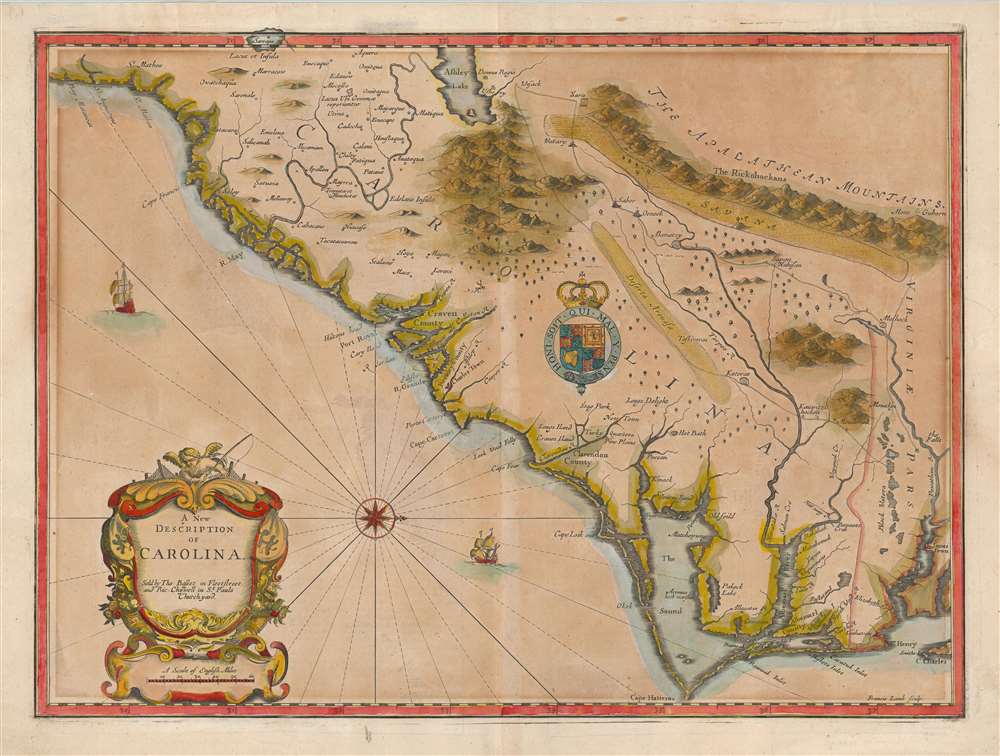
A New Description of Carolina.
1676 (undated) 15 x 20 in (38.1 x 50.8 cm) 1 : 1900000
1676 (undated) 15 x 20 in (38.1 x 50.8 cm) 1 : 1900000
Description
A striking example of the important and scarce map of the Carolina colony engraved by Francis Lamb in 1676, for inclusion in John Speed's atlas. It is one of the earliest early English maps specifically of the colony acquirable by the collector, published just six years after the founding of Charleston. As such, it is a map of seminal importance, and an essential document in the history of the Carolinas specifically, and the British settlements in North America in general.
Prominent on this map is the track of Lederer's second journey of 1670 (the sharp-eyed will find the figures of travelers along it, a feature lacking in the Ogilby). The route runs west from the Falls of the James River before turning southwest at the Mahock village (near Richmond). The track crosses the upper Roanoke River (here called Noratake) at the village of Akenatzy, and roughly follows that river to the village of Watary. The track skirts the eastern edge of great savanna, crossing it before ultimately reaching the shores of Ashley Lake. The track continues, showing Lederer returned along a course passing through a great sandy desert, the Deserta Arenosa, before returning to the coastal wetlands. (Lederer's first and third marches, of 1669 and later in 1670, both took place to the north, skirting the Powhatan, and do not fall within the scope of either this or the earlier Ogilby map.)
In any case, after Lederer, nearly twenty five years would pass before another European explorer documented this region - so as flawed as it may have been, it would stand long as the best available European effort at mapping the region.
The verso text - supplied and edited by Edward Phillips - presents the Lederer narrative.
The Scope of the Map
This westward-oriented map covers from the Spanish colony of St. Augustine, Florida, north to the English colony of Jamestown, Virginia. It extends inland as far as the Appalachian (Apalathean) Mountains. The coast of Carolina is fairly well depicted: St. Augustine, Port Royal, Charleston (Charles Town), Cape Fear, Cape Lookout, Cape Hatteras, Roanoke, Cape Henry and the James River are placed with fair accuracy. The map is rich with place names, many incorporated from earlier maps, including the De Bry - Le Moyne map of 1591: for instance Lake Sarrope, which most likely represents Lake Okeechobee. The River May as it appears here (historically either the St. John's River or the Savannah River), is also likely derived from the Le Moyne. Specifically colonial place names, such as the counties of Albemarle, Clarendon, Berkley, and Craven, appear to be drawn from a more current source: John Ogilby's first Lords Proprietors' Map of 1672.Early Glimpses Beyond the Coastline
Lamb's map is derived from John Ogilby's rare 'A New Description of Carolina,' the so-called 'Lords Proprietors' Map' of 1672. This was the first general map of the colony to incorporate the explorations of John Lederer, and as such, it represents one of the earliest attempts to map the Carolina interior. (The map accompanying Lederer's 1672 account is of much narrower focus, only addressing the tracks of his voyages, and at any rate is of the utmost rarity.) Engraver Francis Lamb had worked for Ogilby on many occasions prior to his engraving for the Speed atlas, so it is reasonable to assume that his familiarity with Ogilby would have made the Lords Proprietors' Map the obvious source to draw upon.John Lederer Cartography
The Lord Proprietor, the Earl of Shaftesbury, commissioned John Lederer, a German physician living in the colony, to explore the interior of the colony. His mission was to search for a pass through the Appalachian Mountains to the Pacific Ocean, or at least to find a connection to the fur trade that had been enriching the Dutch further north. Although Lederer's three voyages never penetrated the Appalachians, they represented the first European glimpse beyond the Carolina coastline. The travels reflected here would significantly impact the cartography of this region for several hundred years, despite accusations of Lederer's having fabricated much of his journey.Prominent on this map is the track of Lederer's second journey of 1670 (the sharp-eyed will find the figures of travelers along it, a feature lacking in the Ogilby). The route runs west from the Falls of the James River before turning southwest at the Mahock village (near Richmond). The track crosses the upper Roanoke River (here called Noratake) at the village of Akenatzy, and roughly follows that river to the village of Watary. The track skirts the eastern edge of great savanna, crossing it before ultimately reaching the shores of Ashley Lake. The track continues, showing Lederer returned along a course passing through a great sandy desert, the Deserta Arenosa, before returning to the coastal wetlands. (Lederer's first and third marches, of 1669 and later in 1670, both took place to the north, skirting the Powhatan, and do not fall within the scope of either this or the earlier Ogilby map.)
Fact or Fiction?
Lederer's journey was met from the start with accusations of fraud: His English traveling companion, a Major Harris, had returned early from the journey with his retinue of soldiers (the two had split at Watary) and on Lederer's return, a resentful Harris would accuse the German Lederer of inventing his discoveries. However, even accounting for exaggeration, major elements of Lederer's report correspond with actual geographical features. Lederer's desert, the Arenosa, probably corresponds with the Sand Hills. The savanna in the piedmont region, which Lederer described as 'marish grounds at the foot of the Apalataei', does not exist today. However, Cumming suggests that 'before the forest land was denuded and the top soil washed away, the piedmont may have had marshy sections, which have since largely disappeared.' The portrayal of this as a vast region is largely based on his having crossed it further north on his first and third explorations; it should be noted that his second march only crosses the region at its southern limit. The assumption that the intervening space was part of the same geographical feature is understandable in that context. The great Lake Ashley, shown as the source of the May River, had appeared on maps of the region going back to the 1691 De Bry/ Le Moyne and Lederer would have been familiar with its appearance on the maps of Hondius, and possibly those derived from the 1612 Lescarbot. Lederer certainly would have expected to find such a lake: and indeed he claimed to have found it and even to have sampled its waters. Some scholars have claimed that Lederer fabricated this discovery to add legitimacy to his explorations. Indeed, the lake had been around on maps for a hundred years and, had he not come across it, many of his other discoveries would have been thrown into doubt. Cummings suggests that Lederer may have turned back somewhat earlier than he claimed and simply added the lake having misunderstood the American Indian sign language describing the wave-like undulations of the Blue Ridge Mountains. Another scholar, Lyman Carrier, suggests that Lederer had actually stumbled across the Catawba Valley where 'had the rivers been obstructed by beaver dames or debris, or had the channels through some of their gorges not been cut to their present levels, large areas of flooded land would have resulted.'In any case, after Lederer, nearly twenty five years would pass before another European explorer documented this region - so as flawed as it may have been, it would stand long as the best available European effort at mapping the region.
A New Edition of 'Speed'
By the time the 1676 edition of John Speed's atlases was published, that author was long dead. Indeed, there had been no edition of Speed's atlases since the great fire of London in 1666, which is partly what spurred publishers Bassett and Chiswell to undertake the work. The publishers tapped poet and writer Edward Phillips to edit the text and add further material. Six new maps, including the present one, were engraved by Francis Lamb: these are all notable as the only maps in the work to be executed by an English engraver, as the maps produced in Speed's lifetime were engraved by Dutch artists.The verso text - supplied and edited by Edward Phillips - presents the Lederer narrative.
Publication History and Census
This map was engraved by Francis Lamb and published in Richard Chiswell's 1676 edition of Theatre of the Empire of Great Britain, which incorporated in one volume both of Speed's atlases. We see eight examples of the separate map cataloged in institutional collections. The map appears on the market from time to time.CartographerS
John Speed (1542 - 1629) was an important English historian and cartographer active in the early 17th century. Speed was born in Fardon, Cheshire and apprenticed under his father as a tailor. Though his heart was never in tailoring, Speed dedicated himself to this profession until he was about 50 years old. During all the time, Speed dedicated his spare time to research as amateur historian and mapmaker - even preparing several maps for Queen Elizabeth. In London, Speed's interest in history lead him to join the Society of Antiquaries. Eventually he befriended the wealthy Sir Fulke Greville, who sponsored his researches and eventually freed him from the haberdashery profession. Working with William Camden, Speed eventually published his 1611 Historie of Great Britaine. Though this history itself was amateurish and of minimal importance, Speed's inclusion of numerous maps of British Cities and town was seminal. In many cases these plans were the first maps ever issued of their respective subjects. Later, turning his attention more fully to Geography, Speed published the magnificent atlas Theatre of the Empire of Great Britaine and, just prior to his death, the 1627 A Prospect of the Most Famous Parts of the World. These were the first British world atlases and have a landmark position in the history of cartography. These atlases continued to be published well after Speed's death. More by this mapmaker...
Francis Lamb (fl. 1667 - 1701) was an English engraver and mapmaker active in London during the second half of the 17th century. Working as an engraver Lamb produced a number of highly influential maps including four plates of the New World for inclusion in the 1676 Basset and Chiswell edition of Speed's "Prospect of the most famous parts of the world". He worked in conjunction many of the most prominent English map publishers of the 17th century including Richard Blome, John Seller, John Ogilby, Robert Morden, William Berry, Moses Pitt, Philip Lea, among others. Little is known of Lamb's personal life however he seems to have been a pupil of the British polymath Robert Hooke, who mentions him regularly in his journals. The dates of Lamb's birth and death are unknown, there is some speculation that he may have died around 1717. Baynton-Williams quotes abundantly with respect to Lamb from Hooke's diary, and the picture is of an exceedingly busy man with connections to many of the best geographical minds of his day. The novel maps he supplied for the 1676 edition of the Speed atlas may well have benefited even more from these connections than from his skill as an engraver. Learn More...
John Ogilby (November 17, 1600 - 1676) was a Scottish translator and cartographer. John Ogilby's life seems to be one of extremes, teetering between wealth and poverty, success and failure. Ogilby was born near Edinburgh, Scotland, into a once wealthy family laid low by extreme debt. Struggling with poverty at every turn, Ogilby involved himself in various businesses ranging from dancing master, to actor, to tutor. In 1612, at age 12, Ogilby won a lottery run to advance the colonial interests of Virginia. His winning were sufficient to pay of many of his father's debts and apprentice himself to a dancing master. Ogilby proved a natural and graceful dancer and even made extra money tutoring his fellow apprentices. Starcrossed as he was, Olgiby's dancing career ended when a misstep when a misstep at a masked ball injured his leg and left him lame for live. Afterwards he managed to leverage his contacts in the dance world to secure a position as a dance instructor to the daughters of Sir Ralph Hopton. Hopton struck an immediate friendship with Olgiby and trained him in Military Science. Later Ogilby relocated to Ireland where he worked an as actor and later as Master of Revels. The Irish Rebellion of 1641 again dashed Ogilby's fortunes and forced him to flee Dublin by ship. On the way, the ship sunk but the survivors were rescued and eventually made their way to England, which was then under the strict rule of Oliver Cromwell. Ogilby took refuge at Cambridge where he mastered Greek and Latin. Following the Restoration of Charles II, Ogilby invested in his first major literary venture, a translation of Virgil into English. This work earned him the patronage of Charles II, despite the ridicule of prominent poets Dryden and Pope. Under Royal patronage Ogilby published several volumes relating to the Restoration. In short order he has established a successful London publisher based out of the Whitefriars district. This, unfortunately turned out to be a fateful choice of location as in 1666 the Great Fire of London tore through this are destroying Ogilby's publishing stock, home, and business. Once again Ogilby exhibited a remarkable phoenix-like ability to literally rise from the ashes. Shortly after the Great Fire, he began his most important ventures as a publisher of geographical works. In order to recover from the fire, Ogilby and his grandson were took positions as surveyors commissioned to create a large property map of London. The resultant map of London, "London Survey'd", was published in 1677 and earned Ogilby the honorific "Kings Cosmographer and Geographic Printer". His most famous works are his 1675 Road Atlas of England, Britannia which redefined road mapping, and his 1671 Atlas of the Americas. Learn More...
John Lederer (1644 - c.1671) was a German born explorer and physician who was one of the first Europeans to explore the western parts of Virginia and Carolina. Born in Hamburg, Germany, Lederer is a rather elusive figure until he appears in Jamestown, Virginia around 1668. The Governor of Virginia was then William Berkeley who believed that the wealth of his colony would be greatly increased if he could find a passage over the Allegheny Mountains to the Pacific - which he believe to be only a few weeks distant. Lederer was the first to take up the commission to explore these lands. The three subsequent voyages make by Lederer from 1669 to 1670 were both controversial and extraordinary influential. While we will not recount Lederer's voyages in detail here, will say that he was the first European to attempt and accurate mapping of the interior of Virginia and Carolina. Lederer was also most likely the first European to see the Shenandoah valley, and the Blue Ridge Mountains. Some of Lederer's more fantastic claims suggest that he discovered a large savanna in the Carolina-Virginia piedmont, that he crossed a great desert in central Carolina, and that he drank from the mythical Lactus Aquae Dulche. Scholars have argued the merits of Lederer's exploration almost from the first instant of his return, some claiming that his claims were false and others suggesting that they true but represent misunderstandings on his part and on the part of his readers. Our own reading of Lederer's narrative argues for the later and for the relative veracity of his claims. Upon returning from this third expedition Lederer found himself deeply in debt and "he was look'd on as so great an insolence, that our traveller at his return, instead of welcome and applause, met nothing but affronts and reproaches". This most likely resulted from an enimenity developed on with one of his traveling companions on the second expedition, one Major Harris. Lederer and Harris traveled together from the Falls of the James River westward to a point where the James River turned creating a wide lake-like passage. Harris declared that he had discovered a southern extension of the "Lake of Canada" and returned to Jamestown to bask in the admiration of his fellow colonists. Lederer however continued, discovering the truth of Harris's "Discovery" and went on to make what would seem to be pretty major discoveries himself. Harris, a popular Englishman, was no doubt humiliated and dishonored at Lederer's return. Lederer, being a German was an easy target for the predominantly English colonists and later left for Maryland where he was welcomed by Governor Charles Clavert. Calvert issued Lederer a patent to trade furs with Indians outside the colonial borders of Maryland. In 1671 Lederer was naturalized as a citizen of Maryland and gave up his German nationality. There he also befriended William Talbot, nephew of Lord Baltimore, who aided him in the publication of his travel narrative "The Discoveries of John Lederer, etc.." in 1672. Lederer's description of Carolina and his map had a significant impact on the cartography of Carolina for the next hundred years. It is uncertain when and where Lederer died. Learn More...
Edward Phillips (1630 – 1696) was a British author and poet. In 1676, he supplied an updated geographical and topographical supplement for the Bassett and Chiswell edition of John Speed's Theatre of Great Britain. He was born in London to Edward and Ann Phillips, who was the only sister of poet John Milton. His father died a year after Edward's birth. Edward would be educated by his poet uncle, and lived with him into his twenties. His education was in the classics, with Latin and Greek literature, but also included modern languages and mathematics. Edward matriculated at Magdalen college in Oxford in 1650 but left without a degree. He instead moved to London to seek work with booksellers. He would publish some few poems, and in 1656 published two novels. Between 1654 and 55 he edited some unpublished manuscripts of the poet William Drummond, to form the collection 'Poems by that most Famous Wit, William Drummond of Hawthornden.' He contributed a prose preface,and some commendatory verses. He produced in 1658 he published a work in lexicography, entitled 'A New World of Words, or a General Dictionary' which would be reproduced in seven editions despite accusations of plagiarism from Thomas Blount, and withering reviews from critics. During this storm, Phillips published a humorous volume, called ‘Mysteries of Love and Eloquence, or the Arts of Wooing and Complimenting as they are managed in the Spring Garden, Hide Park, and other eminent places.' Addressed 'To the youthful gentry,' the work supplied imaginary conversations for lovers, models of love letters, an art of logic, a rhyming dictionary, reprints of poems and songs, a description of a few parlour games, and a vocabulary of epithets. He followed this entertainment with editions of historical works. In 1663 he became a tutor to the son of diarist John Evelyn, and later to Philip, son of Philip Herbert, fifth earl. By the 1670s he had resumed his life as a hack, interspersed with poetic efforts; in 1676 he provided his update to the Speed atlas. In 1682 he issued a Latin dictionary drawn from his uncle's notes, which he had inherited. In 1694 he published a translation of Milton's 'Letters of State,' with a short but valuable memoir. Learn More...
Source
Speed, J., The Theater of the Empire of Great Britian, 1676. Also in, Speed, J., A Prospect of the Most Famous Parts of the World…, (London) 1676.
Condition
Very good. English text from Lederer's narrative on verso. Minor marginal mends. Distinctive old color, refreshed; toning and mat burn from non-archival framing matted over the printed border.
References
OCLC 1031405281. Rumsey 12058.217. Carrier, L.,'The Veracity of John Lederer', William and Mary Quarterly, Series II, Vol. 19, No. 4, p. 435 - 445. Talbot, W., The Discoveries of John Lederer…, 1672. Burden, P. The Mapping ofd North America II 458. Cumming, W., 'Geographical Misconceptions of the Southeast in the Cartography of the Seventeenth and Eighteenth Centuries', The Journal of Southern History, Vol. 4, No. 4., pp. 476-492. Cunz, Dieter, 'John Lederer: Significance and Evaluation', The William and Mary Quarterly, Series II, Vol. 22, No. 2, pp. 175-185. The North Carolina State Archives, MC.150.1676s; MARS Id: 3.3.1.1.63. Phillips (America), p. 817. Cumming, W. P., The Southeast in Early Maps, #77. Goss, J., The Mapping of North America, Three Centuries of Map-Making 1500-1860, 41.