1864 Petermann / Hassenstein Map of Eritrea
Eritrea-petermann-1864$350.00
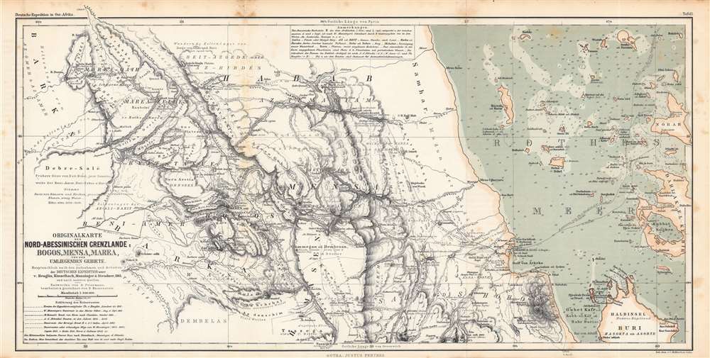

Title
Originalkarte der Nord-Abessinischen Grenzlande Bogos, Mensa, Marea und der umliegenden Gebiete...
1864 (undated) 10.5 x 21 in (26.67 x 53.34 cm) 1 : 500000
1864 (undated) 10.5 x 21 in (26.67 x 53.34 cm) 1 : 500000
Description
This is an 1864 Augustus Petermann and Bruno Hassenstein map of what is today Eritrea, including a nautical chart of the Red Sea along the Eritrean coast. It illustrates the routes of mid-19th century European explorers from the Red Sea westwards to the Sudan.
The routes of several explorers are traced, as denoted by the lines in the legend at bottom-left. Among the earliest and most impressive were the travels of the French-Basque-Irish brothers Antoine Thomson d'Abbadie (1810 – 1897) and Arnaud-Michel d'Abbadie (1815 - 1893), who lived and trekked extensively in Ethiopia and the Horn of Africa in the 1830s - 1850s. Later explorers did not always fare so well. Hermann Steudner fell sick and died in April 1863, while Gottlob Theodor Kinzelbach died by poisoning in 1868 or 1869 at Afgooye (near Mogadishu). The map and the booklet it appeared in were primarily intended to recount the journeys of 'the German Expedition', nominally led by Theodor von Heuglin (1824 - 1876), which landed at Massawa (here as Massua) in 1861, and included Werner Munzinger (1832 - 1875), Kinzelbach, and Steudner. They were tasked with finding the lost explorer Eduard Vogel, who was believed to be in Khartoum but, it was later learned, had been killed in southern Sudan some five years earlier. Although an 'expedition', these explorers in fact acted independently, crossing paths and linking up for a time but then diverging on separate paths and joining up with other expeditions. Aside from seeking Vogel, they were also looking to more fully explore the region and locate the source of the Nile.
The port city of Massawa towards right was eyed by several successive empires, including the Portuguese, the Ottomans, the Egyptian Mehmet Ali Dynasty, and finally the Italians, who in 1885 made it the capital of their Eritrean colony. In 1897, the capital was moved inland to Asmara, at bottom-center, but Massawa continued to be an important port, the largest deep-water port on the Red Sea in the early 20th century.
A Closer Look
This map covers highlands in the west to Keren to the Red Sea in the east, including a beautiful nautical chart in the right third of the map. It utilizes Parisian feet for elevation, German miles for scale, and both Greenwich and Paris as Prime Meridians, while English fathoms are employed for soundings in the Red Sea. A note at top explains the pronunciation of Amharic and Arabic letters while also providing an explanation of terms transliterated from local languages.The routes of several explorers are traced, as denoted by the lines in the legend at bottom-left. Among the earliest and most impressive were the travels of the French-Basque-Irish brothers Antoine Thomson d'Abbadie (1810 – 1897) and Arnaud-Michel d'Abbadie (1815 - 1893), who lived and trekked extensively in Ethiopia and the Horn of Africa in the 1830s - 1850s. Later explorers did not always fare so well. Hermann Steudner fell sick and died in April 1863, while Gottlob Theodor Kinzelbach died by poisoning in 1868 or 1869 at Afgooye (near Mogadishu). The map and the booklet it appeared in were primarily intended to recount the journeys of 'the German Expedition', nominally led by Theodor von Heuglin (1824 - 1876), which landed at Massawa (here as Massua) in 1861, and included Werner Munzinger (1832 - 1875), Kinzelbach, and Steudner. They were tasked with finding the lost explorer Eduard Vogel, who was believed to be in Khartoum but, it was later learned, had been killed in southern Sudan some five years earlier. Although an 'expedition', these explorers in fact acted independently, crossing paths and linking up for a time but then diverging on separate paths and joining up with other expeditions. Aside from seeking Vogel, they were also looking to more fully explore the region and locate the source of the Nile.
The port city of Massawa towards right was eyed by several successive empires, including the Portuguese, the Ottomans, the Egyptian Mehmet Ali Dynasty, and finally the Italians, who in 1885 made it the capital of their Eritrean colony. In 1897, the capital was moved inland to Asmara, at bottom-center, but Massawa continued to be an important port, the largest deep-water port on the Red Sea in the early 20th century.
Publication History and Census
This map was drafted by Augustus Petermann, edited by Bruno Hassenstein, and lithographed by Carl Hellfarth of the publisher Justus Perthes, based in Gotha. It was published as Plate (Tafel) No. 1 of the 1864 booklet Die deutsche expedition in Ost-Afrika, 1861 und 1862…, which was Supplement (Ergänzungsheft) No. 13 to the periodical Petermann's Geographische Mitteilungen. The full distribution of the map is difficult to determine due to inconsistent cataloging, but is known to be held by the British Library, the Bibliothèque nationale de France, the Staatsbibliothek zu Berlin, and the Bayerische Staatsbibliothek, and is scarce to the market.CartographerS
August Heinrich Petermann (1822 - 1878) was a German cartographer. Petermann attended the 'Geographische Kuntschule' (Geographica School of Art), which was started by Heinrich Berghaus with the support of Alexander von Humboldt, in Potsdam beginning in 1839. Students at the school were obliged to work on many of the school's contracts, including maps for several different atlases. Following his time in Potsdam, Petermann relocated to Edinburgh and London from 1845 to 1854, where he gained insight into the commercial aspects of the cartography business. In 1854, Petermann returned to Gotha, Germany and began working with the Perthes brothers publishers. While working with the Perthes brothers, Petermann founded the journal Petermanns Geographische Mitteilungen, published from 1855 until 2014, long one of the most prominent German-language geography journals. More by this mapmaker...
Bruno Hassenstein (November 23, 1839 - August 27, 1902) was a German cartographer and was born in Ruhla, Thuringia. In 1854, Hassenstein began studying cartography and working under August Petermann in Gotha, founder of Petermanns Geographische Mitteilungen. Over the ensuing years, Hassenstein drew numerous maps for Petermanns Geographische Mitteilungen before relocating to Berlin in 1866 to work for another cartographer, including Karl Klaus von der Decken. He returned to Gotha two years later and works on maps for Henrich Theodor Menke's edition of Spurner's atlas of medieval history. He became editor of the cartography section of the Mittellungen in 1878 and worked on the Atlas von Japan, which was published in 1885. The University of Göttingen awarded him an honorary doctorate in 1878. Learn More...
Carl Hellfarth (November 30, 1846 - July 12, 1918) was a German printer. Hellfarth was born in Gotha, Germany. He married Amalie Friederike Marie Möller (1850 - 1916) on June 16, 1873, and they had eight children. Learn More...
Johan Georg Justus Perthes (September 11, 1749 - May 2, 1816) was one of the most important German cartographic engravers of the 19th century. He was born in the Thuringian town of Rudolstadt, the son of a court physician. In 1778, he began working as a bookseller in Gotha. Perthes began his publishing empire shortly thereafter with the 1784 issue of the famed survey of European nobility known as the Almanac de Gotha. In the next year, 1785, he founded the cartographic firm of Justus Perthes Geographische Anstalt Gotha. His son Wilhelm Perthes (1793 - 1853) joined the firm in 1814. Wilhelm had prior publishing experience at the firm of Justus Perthes' nephew, Friedrich Christoph Perthes, who ran a publishing house in Hamburg. After Justus Perthes died in 1816, Wilhelm took charge and laid the groundwork for the firm to become a cartographic publishing titan. From 1817 to 1890. the Perthes firm issued thousands of maps and more than 20 different atlases. Along with the visionary editors Hermann Berghaus (1797 - 1884), Adolph Stieler (1775 - 1836), and Karl Spruner (1803 - 1892), the Perthes firm pioneered the Hand Atlas. When Wilhelm retired, management of the firm passed to his son, Bernhardt Wilhelm Perthes (1821 – 1857). Bernhardt brought on the cartographic geniuses August Heinrich Peterman (1822 - 1878) and Bruno Hassenstein (1839 - 1902). The firm was subsequently passed to a fourth generation in the form of Berhanrd Perthes (1858 – 1919), Bernhard Wilhelm's son. The firm continued in the family until 1953 when, being in East Germany, it was nationalized and run as a state-owned enterprise as VEB Hermann Haack Geographisch-Kartographische Anstalt Gotha. The Justus family, led by Joachim Justus Perthes and his son Wolf-Jürgen Perthes, relocated to Darmstadt where they founded the Justus Perthes Geographische Verlagsanstalt Darmstadt. Learn More...
Source
Ergänzungsheft No. 13, Petermann’s Geographische Mitteilungen, (Gotha: Petermann), 1864.
Condition
Good. Foxing along fold lines and in margins.
References
OCLC 1249626949, 556535061, 556634590.