Digital Image: 1869 Direccion Hidrografía Map of South China Sea - Hong Kong to Hainan
Hainan-direccionhidrografia-1869_d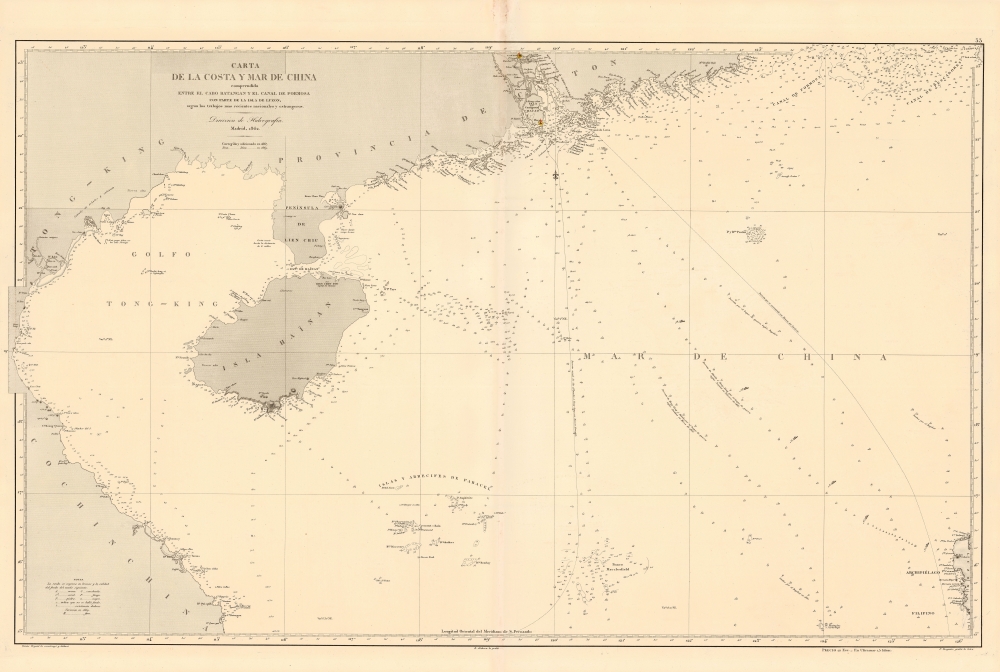

Title
Carta de la Costa y Mar de China comprendida entre el Cabo Batangan y el Canal de Formosa con parte de la Isla de Luzon, segun los trabajos mas recientes macionales y estrangeros.
1869 (dated) 26 x 39 in (66.04 x 99.06 cm) 1 : 1580000
1869 (dated) 26 x 39 in (66.04 x 99.06 cm) 1 : 1580000
Description
FOR THE ORIGINAL ANTIQUE MAP, WITH HISTORICAL ANALYSIS, CLICK HERE.
Digital Map Information
Geographicus maintains an archive of high-resolution rare map scans. We scan our maps at 300 DPI or higher, with newer images being 600 DPI, (either TIFF or JPEG, depending on when the scan was done) which is most cases in suitable for enlargement and printing.
Delivery
Once you purchase our digital scan service, you will receive a download link via email - usually within seconds. Digital orders are delivered as ZIP files, an industry standard file compression protocol that any computer should be able to unpack. Some of our files are very large, and can take some time to download. Most files are saved into your computer's 'Downloads' folder. All delivery is electronic. No physical product is shipped.
Credit and Scope of Use
You can use your digial image any way you want! Our digital images are unrestricted by copyright and can be used, modified, and published freely. The textual description that accompanies the original antique map is not included in the sale of digital images and remains protected by copyright. That said, we put significant care and effort into scanning and editing these maps, and we’d appreciate a credit when possible. Should you wish to credit us, please use the following credit line:
Courtesy of Geographicus Rare Antique Maps (https://www.geographicus.com).
How Large Can I Print?
In general, at 300 DPI, you should at least be able to double the size of the actual image, more so with our 600 DPI images. So, if the original was 10 x 12 inches, you can print at 20 x 24 inches, without quality loss. If your display requirements can accommodate some loss in image quality, you can make it even larger. That being said, no quality of scan will allow you to blow up at 10 x 12 inch map to wall size without significant quality loss. For more information, it is best consult a printer or reprographics specialist.
Refunds
If the high resolution image you ordered is unavailable, we will fully refund your purchase. Otherwise, digital images scans are a service, not a tangible product, and cannot be returned or refunded once the download link is used.
Cartographer S
The Direccion Hidrografía (1787 - 1927), also known as the Deposito Hydrografico and the Direction de Hidrografía, was the Spanish equivalent of the British Admiralty or the U.S. Coast Survey. This organization, founded in 1787, was commissioned to collect and produce accurate nautical charts of all waters frequented by Spanish vessels. In essence, it replaced the Casa de la Contratación de las Indias (House of Trade of the Indies), which closed its doors in 1790. Like most such organizations, the Direccion Hidrografía marked a new age in cartography. Rather than simply collect charts created by navigators, explorers, and merchants, the Direccion Hidrografía worked closely with naval and military personnel to mount cartographic and hydrographic expeditions in pursuit of the most accurate hydrographical, astronomical, and geodetic measurements. The Direccion Hidrografía created a massive library of nautical charts that, though not nearly as common as similar nautical charts by the U.S. Coast Survey and British Admiralty, are highly desirable for the beauty of their manufacture as well as their accuracy and detail. The office was originally located on Calle Ballesta, but relocated to 36 Alcala, both in Madrid. After 1908 the Dirección was subsumed into other governmental agencies. In 1927 the Direccion was absorbed into the Institute and Observatory of San Fernando, located in Cadiz. The library of original maps, charts, and journals was transferred to the Naval Museum of Madrid - where it resides to this day. More by this mapmaker...
Tomás Bryant y Galiano (fl. c. 1858 – 1879) was a Spanish navigator, sea captain, and chart maker active in the second half of the 19th century. Little is known of Bryant's life, but he appears to have been the grandson of a prominent Spanish shipbuilder Eduardo Bryant and son of Tomás Bryant y Smith (1748 – 18??). Bryant is best known for his charts of Spanish-American waters in the Caribbean and South America published by the Dirección de Hidrografía. Learn More...
Ramón Alabern Y Moles (December 18, 1811 - 1888) was a Catalan map engraver active in Madrid and Barcelona in the early to mid-19th century. Ramón was born in Begues, just outside Barcelona, and initially studied engraving under his older brother, Pablo Alabern Y Moles (1804 - 1860). He afterward traveled to Paris to master to most sophisticated map engraving techniques. There he learnt the daguerreotyping, an early photographic technique, under the technique's inventor, Louis Jacques Mandé Daguerre (1787 - 1851). Returning to Barcelona in 1839, he introduced daguerreotyping to Spain with a dramatic presentation in partnership with the Real Academia de Ciencias Exactas, Físicas y Naturales. Throughout his career, Ramón supplemented his income as a map engraver for the Direccion Hidrografía with photography, publishing several daguerreotype compilations. Alabern died in Madried in 1888. Learn More...
Francisco Bregante y Orbay (fl. 1840 - 1867) was a Spanish engraver and draftsman active with the Dirección Hidrografía in the middle part of the 19th century. Bregante y Orbay specialized in lettering and text. A relative, Salvador Bregante y Orbay, also worked for the Dirección Hidrografía in a related capacity. Learn More...
References
OCLC 1039995003.