1597 Franco / Valle map of Hungary and Transylvania
Hungary-franco-1597$600.00

Title
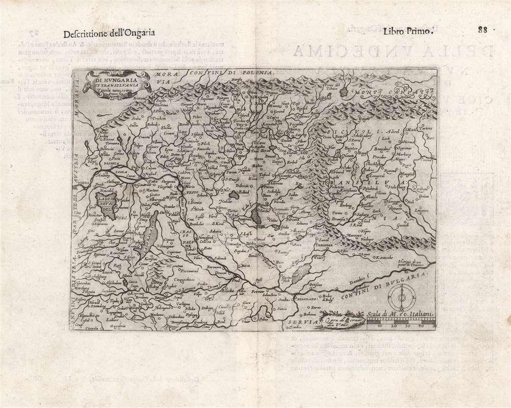
Di Hungaria et Transilvania Tavola novissima Franco for.
1597 (undated) 6.75 x 9.25 in (17.145 x 23.495 cm) 1 : 2400000
1597 (undated) 6.75 x 9.25 in (17.145 x 23.495 cm) 1 : 2400000
Description
This is a rare 1597 map of Hungary and Transylvania by the Venetian mapmaker Giacomo Franco. The map is credited as the work of Bernardino Valle, that draftsman's sole known work. It is derived from the cartography of János Zsámboky, probably via the intermediary of Abraham Ortelius.
A Closer Look
The map is focused on the course of the Danube stretching from Vienna to modern-day Romania and Serbia; the remains of Trajan's bridge across the Danube are marked. Vienna, Buda, Pest, and Belgrade are all marked and named.An Evocative Engraving
The mountainous terrain is depicted pictorially and vigorously, particularly the Carpathian mountains confining Transylvania. Though small, an elegant cartouche graces the upper left, and the lower right includes a simple compass rose and the scale in Italian miles. Next to these is Valle's imprint, shown within a grassy cartouche.Publication History and Census
This map first appeared in 1597, in Cesare Campana's Compendio historico delle guerre ultimamente successe tra Christiani e Turchi e tra Turchi e Persiani. The plate was promptly re-used, without change, in the 1598 Rosaccio edition of Ruscelli's Ptolemy. While the plate was not altered, the letterpress typography is distinctive, and conforms to the Rosaccio printing. A further re-use of the map occurred in the Lasor a Varea Universus terrarum orbis scriptorum calamo delineates, printed in Padua in 1713. Rosaccio's Ptolemy is well represented in institutional collections, but this separate map is rare. One badly miscataloged example appears in the Bibliothèque Nationale de France. Two examples belonging to the 1713 Lasor a Varea are also listed in OCLC.CartographerS
Girolamo Ruscelli (1500 - 1566) was an Italian polymath, humanist, editor, and cartographer active in Venice during the early 16th century. Born in Viterbo, Ruscelli lived in Aquileia, Padua, Rome and Naples before relocating to Venice, where he spent much of his life. Cartographically, Ruscelli is best known for his important revision of Ptolemy's Geographia, which was published posthumously in 1574. Ruscelli, basing his work on Gastaldi's 1548 expansion of Ptolemy, added some 37 new "Ptolemaic" maps to his Italian translation of the Geographia. Ruscelli is also listed as the editor to such important works as Boccaccio's Decameron, Petrarch's verse, Ariosto's Orlando Furioso, and various other works. In addition to his well-known cartographic work many scholars associate Ruscelli with Alexius Pedemontanus, author of the popular De' Secreti del R. D. Alessio Piemontese. This well-known work, or "Book of Secrets" was a compilation of scientific and quasi-scientific medical recipes, household advice, and technical commentary on a range of topics that included metallurgy, alchemy, dyeing, perfume making. Ruscelli, as Alexius, founded a "Academy of Secrets," a group of noblemen and humanists dedicated to unearthing "forbidden" scientific knowledge. This was the first known experimental scientific society and was later imitated by a number of other groups throughout Europe, including the Accademia dei Secreti of Naples. More by this mapmaker...
Giuseppe Rosaccio (approx. 1530 - 1620) was a Venetian physician, astrologer, and geographer. He was born in the Venetian city of Pordenone, and graduated from the University of Padua having studied philosophy, medicine and law. He moved to seek his fortune in Tricesimo, where he worked as a physician and may have taught literature. His legal education led him to serve as a judge there in civil trials during the period between 1561 and 1575. 1607 found him in Florence in the service of Grand Duke Cosimo II (patron of Galileo). Rosaccio married, and had at least two children: Leonardo - who died on April 30, 1603 - and Luigi (also rendered as Alouisio), who collaborated with his father in his geographical work.
He was a prolific author, producing as many as forty works disseminating new knowledge (to a lay audience, using the Italian vernacular). These were mostly on the topics of astronomy and his primary interest, geography. He ventured afield on an array of subjects, including essays on Islam. He remains best known for his geographical texts, which were popular and republished in multiple editions. These included a 1598 edition of Ptolemy, a 1607 geography of Italy, and his final work - the 1610 Discorso nel quale si tratta brevemente della nobiltà, et eccellenza della Terra rispetto à Cieli, et altri elementi, was dedicated to Cosimo II and contained novel information on the American continent, including Drake and Cavendish' circumnavigations. This work included a map drawn by his son Alouisio. Learn More...
Giacomo Franco (1550 - c. 1620) was a Venetian engraver and publisher; in his will he described himself as 'desegnador,' and he was listed as a member of the Venetian painters' guild. He was the son of painter and engraver Battista Franco. He was regarded chiefly as an illustrator, being known mostly for two works describing Venetian costume. He published Giuseppe Rosaccio's 1605 Viaggio Da Venetia a Costantinopoli, and his imprint appears on at least one of the maps in that work - a general chart of the Turkish - held Mediterranean. He also contributed at least one map to Rosaccio's 1598 edition of Ramusio's Ptolemy, a modern map of Hungary and Transylvania. Tooley attributes a 1589 plan of Rome to him. Bifolco and Ronca identify many works belonging to Franco, including several plans of Venice, Rome, and a fine map of Cyprus. Learn More...
Bernardin Valle (fl. 1597) was an Italian, probably Venetian, draftsman and geographer. He is associated with a single known map - Hungary and Transylvania - engraved by Giacomo Franco and appearing in at least two works: the 1597 Cesare Campana Compendio historico delle guerre ultimamente successe tra Christiani & Turchi & tra Turchi & Persiani, and the 1598 Rosaccio edition of Ruscelli's Ptolemy. Learn More...
János Zsámboky, or Johannes Sambucus,(June 1, 1531 - June 13, 1584) was a Hungarian humanist polymath. He is best known for his emblem book, Emblemata cum aliquot nummis antiqui operis, published in five editions starting in 1564. He had studied in Vienna, but traveled broadly: he studied and worked in Leipzig, Wittenberg, Ingolstadt, Strasbourg, Paris, Venice, Padua, Genoa, Naples, Milan, Ghent, and Antwerp. He would be appointed court physician of Emperor Maximilian II, and prospered in that association, allowing him to amass wealth, influence, and an impressive library. His works included several maps - Hungary, Transylvania and Illyricum - which provided the basis for Abraham Ortelius' maps of those regions. Ortelius' decision to use Sambucus' maps speaks both to his influence, as well as a shared interest: Like Ortelius, Sambucus collected coins. Learn More...
Source
Ruscelli, G., La Geografia di Claudio Tolomeo Alessandrino…, (Venice: Heredi di Melchoir Sessa) 1599.
Beginning in 1561, Girolamo Ruscelli published this important, expanded edition of Giacomo Gastaldi's 1548 Ptolemy. Its maps, engraved in Venice by Giulio Sanuto, were in the main based directly upon those in Gastaldi's 1548 work. The maps were larger format than Gastaldi's, however, and Sanuto's engraving was far clearer and more legible than those appearing in the 1548 work. There are some important additions that distinguish Ruscell's Ptolemy from Gastaldi's. Ruscelli's work contained a map of the habitable world according to Ptolemy, which the Gastaldi lacked; also, the double-hemisphere map appearing in the Ruscelli was new and did not appear in the Gastaldi. Ruscelli's modern map of England was based on the work of George Lily, rather than the Waldseemüller-derived map appearing in the Gastaldi; the Ruscelli is the earliest generally acquirable map of England based on knowledge from someone who lived there. In a fateful innovation, Ruscelli's work included Septentrionalium partium nova tabula,the first copy of Nicolo Zeno's 1558 fraud Carta da Navegar, which introduced a novel mapping of the north parts of the world, including the phantom islands of Frisland, Icaria, Drogeo and Estotiland. Had Ruscelli not copied the Zeno - which had a narrow, brief publication - this preposterous geography would have probably not taken hold. Its inclusion in Ruscelli's beautiful, authoritative and popular work would lead to the adoption of the Zeno map by Mercator, Ortelius, Plancius and their successors, baffling scholars for centuries. Ruscelli's Ptolemy had a long publication history, cementing the influence of the work. It appeared both in Italian and Latin editions, all printed in Venice, throughout the latter 16th century:
- 1561 La Geographia di Claudio Tolomeo Alessandrino, Italian. Venice, Vincenzo Valgrisi.
- 1562 Geographia Cl. Ptolemaei Alexandrini, Latin. Venice, Vincenzo Valgrisi.
- 1564 La Geographia di Claudio Tolomeo Alessandrino, Italian. Venice, Giordano Ziletti.
- 1564 Geographia Cl. Ptolemaei Alexandrini, Latin. Venice, Giordano Ziletti.
- 1574 La Geographia di Claudio Tolomeo Alessandrino, Italian. Venice, Giordano Ziletti.
- 1598 Geographia di Claudio Tolomeo Alessandrino, Italian. Venice, heirs of Melchoir Sessa.
- 1599 Geographia di Claudio Tolomeo Alessandrino, Italian. Venice, heirs of Melchoir Sessa.
Condition
Very good. Some marginal stains, else excellent.
References
OCLC 164329298 (1713 Padua edition), 1045617197 (full text).