1770 John Speed County Map of Leicester (Scarce Dicey Edition)
Leicester-speed-1770$750.00
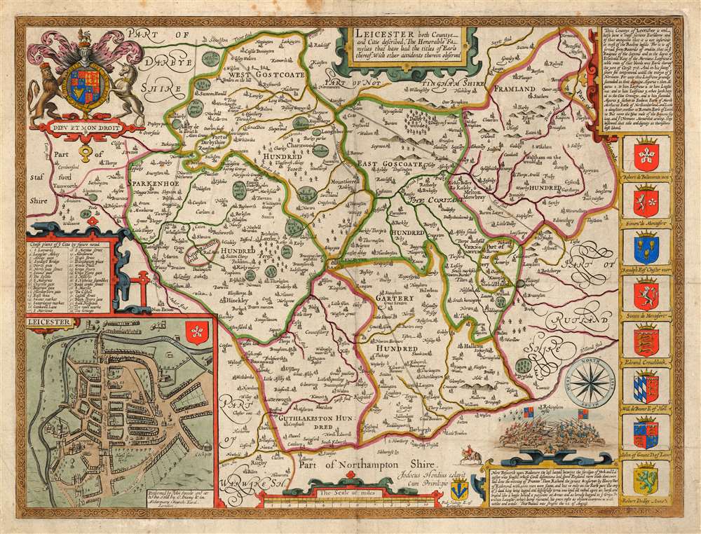

Title
Leicester, both Countye and Citie described, the Honorabe Famylies that have had titles of Earls thereof. With other accidents therein observed.
1770 (undated) 15 x 19.5 in (38.1 x 49.53 cm) 1 : 120000
1770 (undated) 15 x 19.5 in (38.1 x 49.53 cm) 1 : 120000
Description
This is John Speed's 1770 map of the East Midlands county of Leicestershire, England. It was first included in Speed's county atlas and remained in publication long after Speed's death, and in this case this specific map was printed in Cluer Dicey's scarce, final edition of 1770. The map is richly detailed, showing towns, abbeys, castles, forests, and parklands. An inset plan in the lower left details the walled town of Leicester with a key naming thirty-four streets, gates and buildings. Along the right side of the map are displayed the armorial crests of eight of the historical Earls of Leicester. At the bottom are the arms of Robert Sidney, the second Earl of Leicester (probably added by Bassett and Chiswell in 1676). At the upper left are the Royal Arms, with the motto 'Dieu et Mon Droit.'
The Battle of Bosworth
The map is notable for its depiction, at the bottom right, of the Battle of Bosworth: the last important battle of the fifteenth century Wars of the Roses (1455 - 1478). It was fought on August 22, 1485, and won by an alliance of Lancastrians and disaffected Yorkists, who defeated the last king of the House of York. The battle is presented - much after the fashion of Shakespeare's memorialization of it - as a personal defeat of Richard III at the hands of Henry Tudor, the first English monarch of the Tudor dynasty. Richard III was killed during the battle - the last English monarch to die in combat. The site of the battle is marked on the map as 'Kinge Richards Feild' The battle scene here is attended with a descriptive text:Nere Bosworth upon Redemore the last battail betwixt the families of York and Lancaster was fought. Whose Civill discentions had spent England more blode than twice had done the winning of Frannce. There Richard the tyrant and usurper by Henry Earl of Richmond with 4000 men were slaine, and but 10 only on the Earls part. The corps of ye dead King being tugged and dispitefully torne was layd all naked upon an horse, and trussed like a hogge behind a pursivant at Arms and as homely buryed in ye Graye Fr. within Leicester, which being ruinated, his grave rests as obscure overgrowne with nettles and weeds. This battail was fought the 22 of August.The sharp-eyed reader will spy the horse leaving the battlefield to the left, with the stripped body (presumably of the hapless Richard III) draped across its back. The presumed location of Richard III's burial, Greyfriars, is marked as item 23 on the town plan.
Publication History and Census
This map was engraved by Jodocus Hondius in 1608 for inclusion in John Speed's The Theatre of the Empire of Great Britaine, published in London by Sudbury and Humble in 1614. It continued in publication in the atlas in all its editions, including those that were bound together with Speed's A Prospect of the Most Famous Parts of the World. This example bears the imprint of Cluer Dicey, whose scarce edition of Speed's atlases was published in 1770 and was the final imprint of the long-lived work. Perhaps twenty-seven examples of the separate map, in various editions, appear in institutional collections. None of these, however, is of the present Dicey imprint, which appears to be rare.CartographerS
John Speed (1542 - 1629) was an important English historian and cartographer active in the early 17th century. Speed was born in Fardon, Cheshire and apprenticed under his father as a tailor. Though his heart was never in tailoring, Speed dedicated himself to this profession until he was about 50 years old. During all the time, Speed dedicated his spare time to research as amateur historian and mapmaker - even preparing several maps for Queen Elizabeth. In London, Speed's interest in history lead him to join the Society of Antiquaries. Eventually he befriended the wealthy Sir Fulke Greville, who sponsored his researches and eventually freed him from the haberdashery profession. Working with William Camden, Speed eventually published his 1611 Historie of Great Britaine. Though this history itself was amateurish and of minimal importance, Speed's inclusion of numerous maps of British Cities and town was seminal. In many cases these plans were the first maps ever issued of their respective subjects. Later, turning his attention more fully to Geography, Speed published the magnificent atlas Theatre of the Empire of Great Britaine and, just prior to his death, the 1627 A Prospect of the Most Famous Parts of the World. These were the first British world atlases and have a landmark position in the history of cartography. These atlases continued to be published well after Speed's death. More by this mapmaker...
Jodocus Hondius (October, 14 1563 - February 12, 1612) was an important Dutch cartographer active in the late 16th and early 17th centuries. His common name, Jodocus Hondius is actually a Latinized version of his Dutch name, Joost de Hondt. He is also sometimes referred to as Jodocus Hondius the Elder to distinguish him from his sons. Hondius was a Flemish artist, engraver, and cartographer. He is best known for his early maps of the New World and Europe, for re-establishing the reputation of the work of Gerard Mercator, and for his portraits of Francis Drake. Hondius was born and raised in Ghent. In his early years he established himself as an engraver, instrument maker and globe maker. In 1584 he moved to London to escape religious difficulties in Flanders. During his stay in England, Hondius was instrumental in publicizing the work of Francis Drake, who had made a circumnavigation of the world in the late 1570s. In particular, in 1589 Hondius produced a now famous map of the cove of New Albion, where Drake briefly established a settlement on the west coast of North America. Hondius' map was based on journal and eyewitness accounts of the trip and has long fueled speculation about the precise location of Drake's landing, which has not yet been firmly established by historians. Hondius is also thought to be the artist of several well-known portraits of Drake that are now in the National Portrait Gallery in London. In 1593, Hondius returned to Amsterdam, where he remained until the end of his life. In 1604, he purchased the plates of Gerard Mercator's Atlas from Mercator's grandson. Mercator's work had languished in comparison to the rival atlas, Theatrum Orbis Terrarum by Ortelius. Hondius republished Mercator's work with 36 additional maps, including several which he himself produced. Despite the addition of his own contributions, Hondius recognizing the prestige of Mercator's name, gave Mercator full credit as the author of the work, listing himself as the publisher. Hondius' new edition of Mercator revived the great cartographer's reputation and was a great success, selling out after a year. Hondius later published a second edition, as well as a pocket version called the Atlas Minor. The maps have since become known as the "Mercator/Hondius series". Between 1605 and 1610 Hondius was employed by John Speed to engrave the plates for Speed's The Theatre of the Empire of Great Britaine. Following Hondius' death in 1612, his publishing work in Amsterdam was continued by his widow and two sons, Jodocus II and Henricus. Later his family formed a partnership with Jan Jansson, whose name appears on the Atlasas co-publisher after 1633. Eventually, starting with the first 1606 edition in Latin, about 50 editions of the Atlas were released in the main European languages. In the Islamic world, the atlas was partially translated by the Turkish scholar Katip Çelebi. The series is sometimes called the 'Mercator/Hondius/Jansson' series because of Jansson's later contributions. Hondius' is also credited with a number of important cartographic innovations including the introduction of decorative map borders and contributions to the evolution of 17th century Dutch wall maps. The work of Hondius was essential to the establishment Amsterdam as the center of cartography in Europe in the 17th century. Learn More...
Cluer Dicey (1714-1775) was an English printer, publisher and engraver. He was the son of printer, engraver and newspaperman William Dicey (1690-1756), from whom it appears he learned the trade. Cluer joined his father in the business and took charge after William's death. Among other works, he republished the county maps of Christopher Saxton, and produced the final 1770 edition of John Speed's atlas of England and Wales. Learn More...
Source
Speed, John, The English Atlas, or a Complete Set of Maps of all the counties in England and Wales, (London: Dicey, C.) 1770.
Condition
Good condition. Lightly toned, few stains to border. No verso text.
References
Rumsey 12058.074. OCLC 557932587 (Both 1676 Bassett and Chiswell).