Digital Image: 1909 Shackleton Map of the British Antarctic Expedition
NimrodExpedition-shackleton-1909_d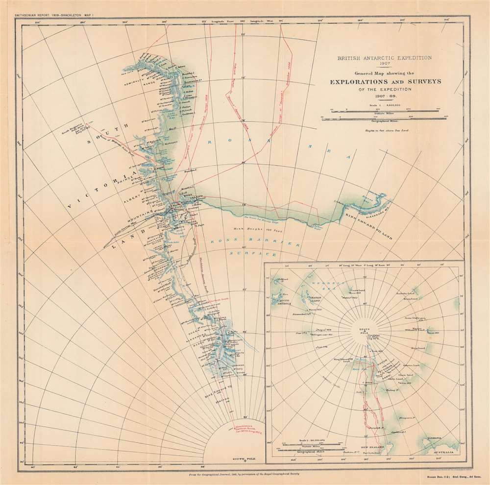

Title
British Antarctic expedition, 1907 : general map showing the explorations and surveys of the expedition, 1907-09.
1909 (dated) 15.5 x 15.5 in (39.37 x 39.37 cm) 1 : 6000000
1909 (dated) 15.5 x 15.5 in (39.37 x 39.37 cm) 1 : 6000000
Description
FOR THE ORIGINAL ANTIQUE MAP, WITH HISTORICAL ANALYSIS, CLICK HERE.
Digital Map Information
Geographicus maintains an archive of high-resolution rare map scans. We scan our maps at 300 DPI or higher, with newer images being 600 DPI, (either TIFF or JPEG, depending on when the scan was done) which is most cases in suitable for enlargement and printing.
Delivery
Once you purchase our digital scan service, you will receive a download link via email - usually within seconds. Digital orders are delivered as ZIP files, an industry standard file compression protocol that any computer should be able to unpack. Some of our files are very large, and can take some time to download. Most files are saved into your computer's 'Downloads' folder. All delivery is electronic. No physical product is shipped.
Credit and Scope of Use
You can use your digial image any way you want! Our digital images are unrestricted by copyright and can be used, modified, and published freely. The textual description that accompanies the original antique map is not included in the sale of digital images and remains protected by copyright. That said, we put significant care and effort into scanning and editing these maps, and we’d appreciate a credit when possible. Should you wish to credit us, please use the following credit line:
Courtesy of Geographicus Rare Antique Maps (https://www.geographicus.com).
How Large Can I Print?
In general, at 300 DPI, you should at least be able to double the size of the actual image, more so with our 600 DPI images. So, if the original was 10 x 12 inches, you can print at 20 x 24 inches, without quality loss. If your display requirements can accommodate some loss in image quality, you can make it even larger. That being said, no quality of scan will allow you to blow up at 10 x 12 inch map to wall size without significant quality loss. For more information, it is best consult a printer or reprographics specialist.
Refunds
If the high resolution image you ordered is unavailable, we will fully refund your purchase. Otherwise, digital images scans are a service, not a tangible product, and cannot be returned or refunded once the download link is used.
Cartographer S
Ernest Shackleton (February 15, 1874 - January 5, 1922) was one of the most accomplished Antarctic explorers in history. Born in Ireland to an Anglo-Irish family, Shackleton joined the Discovery Expedition in 1901 - 1904, one of the first British expeditions to the Antarctic in decades, following the initial discoveries of James Clark Ross in the 1830s-1840s. During the Discovery Expedition, Shackleton and Edward Adrian Wilson set a record for furthest latitude south reached. The 1907 - 1909 Nimrod Expedition, which Shackleton led, went further south yet, establishing a new record and reaching within 100 miles of the South Pole. Shackelton was knighted on his return to Britain and became a well-known public speaker, giving lectures about his experiences and polar exploration more generally. He then led another expedition in 1914 – 1917, named for one of its ships, the Endurance, that attempted to cross the land portion of Antarctica. The expedition went horribly wrong when the Endurance was stuck in ice and then crushed, leaving the men stranded. Shackleton led them on a months-long journey over hundreds of miles of ice and open water in a small boat, managing to ultimately return all the men safely. In 1921, Shackleton died from a heart attack on his ship off the coast of South Georgia Island while preparing for another expedition to the Antarctic. He was largely forgotten alongside other polar explorers of the era until the early 21st century, when a documentary and television miniseries starring Kenneth Branagh as Shackleton recounted his exploits during the Endurance expedition. More by this mapmaker...
Royal Geographical Society (fl. 1830 - present) is a British Society established in 1830 to promote geographical science and exploration. Originally titled the "Geographical Society of London", the RGS received its royal charter from Queen Victoria in 1859 shortly after absorbing several similar but more regional societies including the African Association, the Raleigh Club and the Palestine Association. The RGS sponsored many of the most important and exciting voyages of exploration ever undertaken, including the exploration of Charles Darwin, David Livingstone, Robert Falcon Scott, Richard F. Burton, John Speke, George Hayward, H. M Stanley, Ernest Shackleton and Sir Edmond Hillary. Today, the RGS remains a leading global sponsor of geographical and scientific studies. The Society is based in Lowther Lodge, South Kensington, London. Learn More...
The United States Geological Survey (1878 - Present), aka the U.S.G.S., is a scientific agency of the United States government, which was founded in 1879. USGS scientists study the landscape of the United States, its natural resources, and the natural hazards that threaten it. The organization has four major science disciplines: biology, geography, geology, and hydrology. It is a bureau of the United States Department of the Interior and is the department's only scientific agency. Learn More...
Source
Annual report of the Board of Regents of the Smithsonian Institution ... 1909, (Washington DC: Government Printing Office), House doc. 112, 61st Cong., 2nd sess., Serial Set 5818.
References
OCLC 712805692.