
1971 Abdullah / De Agostini Arabic Wall Map of Abu Dhabi

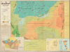
أبوظبي خريطة طبيعية / [Abu Dhabi Physical Map].
Earliest Map of Abu Dhabi after Independence.
Earliest Map of Abu Dhabi after Independence.
This is a large-format c. 1971 Arabic-language map of Abu Dhabi and environs prepared by Mohamed Morsi Abdullah. It constitutes the earliest official map of Abu Dhabi as an independent, post-colonial entity and as the capital of the United Arab Emirates (U.A.E.).A Closer Look
The colorful map covers Abu Dhabi (shaded red, towards top-right) and indeed much of the United Arab Emirates, from Qatar (قطر) in the west to Sharjah (الشارقة) in the east. In the Persian Gulf, purple shading indicates areas for pearl diving, the major industry in this region before the discovery of oil. Additional shading is used to indicate elevation and oases (green). An extensive legend at left provides explanations for the representation of terrain, waterways, and features such as settlements, roads, ports and airports, oil fields, and pipelines. Archaeological sites, a particular interest of Abdullah, are also noted.Below the legend is a section of text titled 'Oil in Abu Dhabi' (النفط في أبو ظبي) providing a history of oil exploration and exploitation in the territory, from the earliest efforts in the late 1930s to drilling operations begun in February 1970 by the Middle East Oil Company, a Japanese consortium led by the Mitsubishi Group. Another strip of text along the right side of the map gives geographic details about Abu Dhabi, its area, its constituent islands, its population, the royal family, and so on. Four inset maps appear at bottom, focusing on oil concessions (color-shaded by company), the Liwa oases villages, Al-Ain and its suburbs, and the island/ city of Abu Dhabi itself. The cover includes an image of Sheikh Zayed bin Sultan Al Nahyan (1918 - 2004), the ruler of Abu Dhabi and first president of the U.A.E.
Abu Dhabi and the Formation of the U.A.E.
In the mid-20th century, Abu Dhabi was one of several Trucial States along the Persian Gulf coast under British protection, a status that dated back to the early nineteenth century when Britain sought to secure maritime routes to India (technically, the states were part of the East India Company's Persian Gulf Residency and then the Raj, with the Indian rupee was the de facto currency among the territories). The discovery of oil in 1959 transformed Abu Dhabi from a poor pearling and trading society into a state of growing economic and political significance. In 1968, when Britain announced its intention to withdraw from 'east of Suez' by 1971, Abu Dhabi's ruler, Sheikh Zayed, took the lead in organizing a new political framework to ensure stability after the end of British oversight. Zayed entered negotiations with the rulers of the other Trucial States, as well as Bahrain and Qatar, to form a federation that would balance local autonomy with collective security and development.These efforts culminated in the creation of the U.A.E. on December 2, 1971, one day after formal independence from Britain, when Abu Dhabi and five other emirates (Dubai, Sharjah, Ajman, Umm al-Quwain, and Fujairah) formally united, with Ras al-Khaimah joining in early 1972. Abu Dhabi, the largest and wealthiest emirate, became the capital of the new federation, and Sheikh Zayed was chosen as its first president. The constitution of the U.A.E. established a federal system that preserved the sovereignty of each emirate while centralizing key areas such as defense, foreign policy, and economic coordination. Abu Dhabi's oil wealth and Zayed's leadership provided the financial and political foundation for the federation's early stability and rapid modernization.
Publication History and Census
This map was prepared by Mohamed Morsi Abdullah, utilizing earlier work undertaken by Federico de Agostini, of the Agostini family of cartographers and map publishers. This map is undated, and in catalog listings, it is dated anywhere between 1969 and 1973. Abdullah's biographies indicate that the map was prepared over many months and likely was released in tandem with Abu Dhabi's independence and the creation of the United Arab Emirates in early December 1971. This Arabic-language edition of the map is especially scarce, only being listed among the holdings of the Library of Congress, the University of California, Berkeley, and the University of Exeter (the National Library and Archives of the U.A.E. also presumably holds an example), while an English-language edition ('Abu Dhabi Physical Map,' OCLC 5569784) is more widespread.Cartographers
Mohamed Morsi Abdullah (December 18, 1929 - October 4, 2005; محمد مرسي عبد الله) was an Egyptian-Emirati historian and cartographer who was one of the earliest social scientists in the United Arab Emirates. He was born in Beni Suef, Egypt to a middle-class family, with his father serving as a police officer and later a government administrator and his mother coming from an esteemed family that was descended from the Prophet Mohammed (thus Abdullah was sometimes known as Sharif Mohamed Morsi Abdullah). Abdullah enrolled at Cairo University as an engineer, but soon switched to the liberal arts, focusing on history. After graduation, he worked in the tourism sector and as a teacher in several countries, eventually becoming a high school principal in Doha, Qatar. Abdullah became convinced that Arabs needed to write their own history rather than leave the task to Western historians, and thus he earned a master's degree in at the University of Cairo in 1965 with a thesis on Saudi-Omani relations, utilizing British, French, and Ottoman archives. Due to his expertise on international relations on the Arabian Peninsula, he was recruited to work in a Documents and Research Bureau (مكتب الوثائق والدراسات, forerunner to the U.A.E. National Archives), where he prepared the first official maps of Abu Dhabi and the United Arab Emirates. Abdullah was encouraged by Zayed bin Sultan Al Nahyan, the ruled of Abu Dhabi and the first President of the United Arab Emirates, to pursue a doctoral degree at the University of Cambridge, which he completed in 1975. Soon before completing his degree, Abdullah was appointed the Director General of the Documents and Research Bureau, a position he held until 1999. Abdullah was an active historian who published several books on the history and foreign relations of the United Arab Emirates and Abu Dhabi specifically. Further Details...
Giovanni De Agostini (August 23, 1863 - November 21, 1941) was an Italian cartographer and publisher. In 1901, he founded the Istituto Geografico Italiano del dott. G. De Agostini and C. in Rome. In addition to school atlases, the group published the Calendario Atlante de Agostini, a compact yearbook, calendar, and atlas, which was highly successful. In 1908, the company moved to Novara in Piemonte, in large part to be closer to Germany, from where they sourced their equipment. In 1919, the company was acquired by Marco Boroli and Cesare Rossi and began to expand more rapidly, including the installation of Italy's first rotogravure printing press and the publication of the esteemed Grande Atlante Geografico, though it retained its name and identity. After De Agostini's death, the Istituto geografico and publishing house he had founded continued to use his name. His younger brother, Alberto Maria de Agostini (1883 - 1960) was a Salesian priest and polymath who lived most of his life in Tierra del Fuego and Patagonia, contributing greatly to the geographic and ethnographic knowledge of the region. Giovanni's son, Federico De Agostini (1905 - 1960), began working at the firm in 1927 and was known for his own discoveries in South America as well as several important maps, textbooks, encyclopedias, and murals, including some in Arabic. Another of Agostini's sons, Giovanni De Agostini, Jr., became especially adept at speaking and reading Arabic and was an expert on the history of Islam. In the years after the Second World War, the company retained the name Agostini but was fully taken over by the Boroli family. It diversified into publishing school textbooks, books on art, children's books, encyclopedias, and more. In subsequent decades, it became one of the best known Italian publishing houses and expanded throughout Europe to become a multifaceted international holding company with publishing, cartographic, arts, media, gaming, and asset management subsidiaries. Further Details...
Condition
Good. Reinforced centerfold splits and a few fold intersections with minor reinstated loss.
References
OCLC 5569783, 1088540361.