
1908 Ottoman Ministry of Public Education Wall Map of Africa

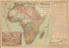
مفصل افريقا خريطة / [Detailed Map of Africa].
Ottoman Irredentism in Africa.
- Digital Map Information
- Suitable for large format printing
- Full resolution TIFF file
- ICC color profile embedded
- Delivered instantly via download link
Ottoman Irredentism in Africa.
This is a rare, large-format Ottoman Turkish wall map of Africa, produced c. 1908 by the empire's Ministry of Public Education. It reflects the efforts of Ottoman reformers to disseminate geographic knowledge through the education system while also reinforcing pride in the empire through irredentism and maximalist territorial claims.A Closer Look
The map is highly detailed, recording cities and other settlements, rivers, lakes, and mountains throughout the continent, even well into the interior. Telegraph and rail lines (existing, under construction, and proposed) are traced throughout, including a representation of the proposed 'Cape to Cairo' Railway championed by Cecil Rhodes (1853 - 1902). A color-shading system is used to distinguish the holdings of different European empires (including the Ottomans), the remaining independent African kingdoms (such as Morocco and Ethiopia), and smaller chieftainships. Notably, and rather absurdly, the entire northeastern quadrant of Africa, except Ethiopia, is shaded the same red color (for the 'Sublime Ottoman State' دولت علیه عثمانیه), and is labeled in large text as 'Ottoman Africa' (افریقای عثمانی). In reality, aside from a handful of semi-autonomous sanjaks roughly consistent with today's Libya, the Sultan had only a tenuous historical claim to suzerainty over the Khedivate of Egypt (a British Protectorate by this point) and even more questionable claims over the Horn of Africa, where the Ottomans had exercised a sort of 'sphere of influence' at the height of their imperial power, let alone the interior of East Africa. The existence of British Protectorates in Egypt and East Africa, as well as French Algeria, is only subtly referred to by solid red demarcation lines (خط امتیاز). This viewpoint mirrors both the shame of Ottoman modernizers at the current state of affairs (as large portions of the empire had been gradually sliced off by European empires and national independence movements) and the desire to reclaim the empire's historical significance.In addition to the main map, both a map and a bird's-eye view of the Suez Canal (سويش قنالنک) are included, reflecting the canal's centrality to transportation and commerce at the time, as well as, perhaps, an unspoken hope that it could fall under Ottoman control in the future. Indeed, in 1915 during World War I (1914 - 1918), not long after this map's publication, the Ottomans attempted to seize the canal in early 1915 but were repulsed by British troops. At right is a large statistical table comparing the cumulative colonial possessions of the various powers (including the ambitious Ottoman claims) and independent African kingdoms, as well as totals for the continent as a whole, across fields such as area, population, commerce, communications lines, and military power.
Historical Context
During the late 19th and early 20th centuries, the Ottoman Empire underwent a sweeping educational overhaul aimed at state survival and modernization. Driven by the Tanzimat reforms and later accelerated under Sultan Abdulhamid II (r. 1876 - 1909), the empire sought to centralize schooling under the Ministry of Public Education (Maarif-i Umûmiyye Nezâreti). This era witnessed a major pivot away from traditional, localized religious madrasas toward a standardized, Westernized system of state schools. The ultimate goal was to produce a new cadre of secularly educated bureaucrats, military officers, and citizens who possessed the modern scientific knowledge required to defend the empire and foster a cohesive Ottoman identity to counter the centrifugal nationalist forces pulling the empire apart.Geographical education played a central role in this project, becoming a tool of statecraft, imperial defense, and territorial consciousness. To survive geopolitically, the state needed its youth to comprehend both their own borders and global power dynamics. This necessity drove a boom in the production of sophisticated, Western-style cartography and specialized textbooks. Frequently compiled by highly trained military officers who doubled as educators, these detailed maps and atlases were vetted by the Ministry of Public Education to instill a modern, spatial understanding of the world in students across the empire.
Africa would have held special prominence for the Ottomans; though they are often remembered as building an empire that bridged Europe and Asia, the Ottoman Empire in fact spanned three continents at its height. Religious, economic, and cultural ties with northern Africa, in particular, were an important factor in the empire's endurance, and the loss of these ties certainly played a significant role in its downfall. In particular, Egypt's loss in the early 19th century and Muhammed Ali's near-successful takeover of the Sublime Porte were major blows to the prestige of the Sultan and the Ottoman state. As mentioned above, the map reflects an irridentist and maximalist view of the empire's territory, even though the Sultan had no authority whatsoever in most of these African territories.
Publication History and Census
This map was prepared by military officers Major el-Hacc Mehmed Nasrullah (بنباشی الحاج محمد نصرالله) and Adjutant Major (Kolağası) Mehmed Rüşdi (قول اغاسی محمد رشدی), printed by the Ottoman Printing House (مطبعه عثمانيهده / Matbaa-i Osmâniyye) in Istanbul, and published by the Ministry of Public Education (معارف عمومیه نظارت / Maârif-i Umûmiye Nezâreti). It is dated 1323 (۱۳۲۳) AH, which could be 1907 or 1908 based on the late Ottoman Rumi Calendar. The text in the top-right margin suggests that the map was sold at the Füyûzât Bookstore (فیوضات کتابخانهسی) on Bab-ı Ali Avenue in Istanbul, a well-known publisher and bookshop of the era. We are only aware of one example of this map in institutional collections, seemingly an earlier edition (1905 / 1323 AH) held by the Library of Congress.Cartographer
Maarif-i Umumiye Nezareti (1857 - November 4, 1922), or Maarif-i Nezareti for short, was the Ministry of Public Education in the closing decades of the Ottoman Empire. As part of Ottoman administrative reforms and modernization efforts in the early 19th century, a bureaucracy for managing education developed in stages, with a dedicated office (Mekatib-i Rüştiye Nezareti) established in 1838. With the Tanzimat reforms, this office was elevated to a ministry in 1857. It oversaw important changes to the education system in the 19th century, including the establishment of secondary schools and universities and the increasing secularization of education. Further Details...
Condition
Very good. Light creasing. Closed tear extending 1.5 inches into printed area from right margin professionally repaired on verso.
References
OCLC 1372584304 (earlier ed.).