1800 Dezauche / De l'Isle Map of America
America-dezauche-1800$750.00
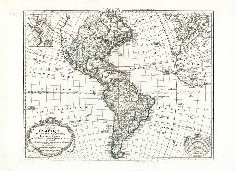

Title
Carte D'Amerique Dressée Pour L'Instruction, Par Guil. Delisle Et Phil. Buache, Premiere Geographe de l'Academie des Sciences. Nouvellement Revue, Augmentée et Assujetie aux N.les Observations Astronomiques et Mrs. de l'Academie des Sciences. Par Dezauche Géographe, Successeur des Sr. Delisle et Phil. Buache. A Paris chez l'Auteur Rue des Noyers. Garantie Nationale An 9. 1800.
1800 (dated) 18.5 x 23.75 in (46.99 x 60.325 cm) 1 : 31000000
1800 (dated) 18.5 x 23.75 in (46.99 x 60.325 cm) 1 : 31000000
Description
This is Jean-Claude Dezauche's 1785 map of the Western Hemisphere, here in a superb example of its 1800 revision. While the map has its basis in the similarly titled map first printed in 1722 by De l'Isle, Dezauche did not use the plate inherited from De l'Isle's heir Buache. The map was re-drawn and re-engraved for its 1785 issue, and would be further amended in subsequent printings.
As early as 1790, the Royal Arms were defaced upon the copperplate and the crown changed into a black cap; later that same year the headgear was removed, and the arms replaced with the ribbons, as on the present example. The map's title would be amended: no longer 'Dressée pour l'Usage du Roi', but 'Dressée pour l'instruction. No longer royal geographers, De l'Isle and Buache are referred to as 'Premiers Géographes de l'Academie des Sciences'. The 1785 Royal privilege is replaced with a 'Garantie Nationale'. While some of these changes merely reflect changes from a Royal bureaucracy to a Republican one, it must be said that a publisher who wished to retain the connection between his head and his body would have been wise to remove Royal iconography from his material.
The Map in Detail
Following the basic model of De l'Isle's Carte D'Amerique, this map covers the Western Hemisphere from Pole to Pole and from the Marquesas to include the Guinea coast of Africa, the Atlantic coast of Europe and the Western Mediterranean Sea. De l'Isle's scientific mapping of the hemisphere long provided a platform to present both that mapmaker's speculative geography of the Pacific Northwest and that of his heir Phillipe Buache. It's state-of-the-art mapping of the Mississippi, Great Lakes and maritime Canada were an authoritative base to build on, and late revisions of the plate included Buache's astonishing Sea of the West, as well as his theories regarding a Northwest Passage. The map's treatment of South American geography was mostly restricted to the coastline, with a broad-brush treatment for the Amazon and the Rio de la Plata. De l'Isle's South Pacific showed islands associated with the explorations of Mendana in 1595, Quiros in 1605, and Magellan in 1520. Identifiable islands including 'Terre decouverte par Davis,' the Marquesas, and the Galapagos Islands.Correcting De L'Isle
By 1785, there was so much to correct in De l'Isle's 1722 map that a new plate was required. The islands of the Pacific, as well as the mapping of the Pacific Northwest, have been amended to reflect the exploration of Captain Cook. An inset in the upper left shows the ice floes Cook encountered upon passing through the Bering Strait. The Great Lakes and the Mississippi are shown more precisely than in the 1722 plate, and North America east of the Mississippi has been entirely reworked to reflect the existence of the United States following the 1783 Treaty of Paris. Florida has been corrected from the archipelagic form on De l'Isle's maps to a more recognizable form. In South America, riverine systems are shown in greater detail and precision, and regions of the interior not known or named in the early 18th century (such as the Government of Goiás in Brazil) are included.A Semi-Legendary Chinese Colony in North America
At the northern extreme of the main map (as well as in the inset map of Cook's discoveries), Dezauche includes 'Fousang des Chinois'. Fusang or Fousang is a settlement first documented by the Chinese Buddhist missionary Hui Shen in the 5th century. Hui Shen describes a land some 20,000 Chinese Li (c. 8000 km) east of the China coast. Fusang is further described in the 7th century Book of Liang by Yao Silian. There are also accounts that the land was settled c. 220 BC by a Chinese Emperor of the Han Dynasty. In later days Fusang was commonly used in Chinese poetry to designate Japan, nonetheless the earliest, and presumably most accurate, references keep it distinct. In any case, Hui Shen's description of Fusang with regard to distance and geography, corresponds more with the coastlands of North America than with Japan. The French historian Joseph de Guignes in his 1761 article 'Le Fou-Sang des Chinois est-il l'Amérique? ' promoted this idea, and thus the colony appeared on maps such as this.'Made for the Use of the King'
The re-engraving of the plate offered the opportunity to expand the map's title cartouche significantly. Dezauche was able to use the additional space to emphasize the illustrious lineage of the map, as well as its Royal imprimatur. Dezauche was identified here as 'successor to the Messieurs De l'Isle and Buache,' who themselves were entitled 'First Geographers to the King and the Royal Academy'. The map itself was advertised as being prepared 'for the Use of the King.' The cartouche retained the decorative features of the 1722 map, including the crown and the royal fleurs de lis. Such advertisements and embellishments would not remain fashionable.As early as 1790, the Royal Arms were defaced upon the copperplate and the crown changed into a black cap; later that same year the headgear was removed, and the arms replaced with the ribbons, as on the present example. The map's title would be amended: no longer 'Dressée pour l'Usage du Roi', but 'Dressée pour l'instruction. No longer royal geographers, De l'Isle and Buache are referred to as 'Premiers Géographes de l'Academie des Sciences'. The 1785 Royal privilege is replaced with a 'Garantie Nationale'. While some of these changes merely reflect changes from a Royal bureaucracy to a Republican one, it must be said that a publisher who wished to retain the connection between his head and his body would have been wise to remove Royal iconography from his material.
Publication History and Census
This plate was engraved in 1785 for inclusion in Dezauche's edition of the De l'Isle atlases, and amended several times over a print history that extended as late as 1830. The map is well represented in institutional collections.CartographerS
Guillaume De l’Isle (1675 - 1726) was a French cartographer, and arguably the finest mapmaker at the beginning of the eighteenth century. He was the son of Claude De L'Isle (1644 -1720), a Paris-based historian and geographer under Nicholas Sanson, then the leading light of French cartography. He was the chief proponent of the school of 'positive geography' and the primary figure defining the heights of the Golden Age of French Cartography. Guillaume's skill as a cartographer was so prodigious that he drew his first map at just nine years of age. He was tutored by J. D. Cassini in astronomy, science, mathematics and cartography. By applying these diverse disciplines to the vast stores of information provided by 18th century navigators, Guillaume created the technique that came to be known as 'scientific cartography', essentially an extension of Sanson's 'positive geography'. This revolutionary approach transformed the field of cartography and created a more accurate picture of the world. Among Guillaume's many firsts are the first naming of Texas, the first correct map of the Mississippi, the final rejection of the insular California fallacy, and the first identification of the correct longitudes of America. Stylistically De L'Isle also initiated important changes to the medium, eschewing the flamboyant Dutch style of the previous century in favor of a highly detailed yet still decorative approach that yielded map both beautiful and informative. Guillaume was elected to the French Academie Royale des Sciences at 27. Later, in 1718, he was also appointed 'Premier Geographe du Roi', an office created especially for him. De L'Isle personally financed the publication of most of his maps, hoping to make heavy royalties on their sales. Unfortunately he met an untimely death in 1728, leaving considerable debt and an impoverished child and widow. De L'Isle's publishing firm was taken over by his assistant, Phillipe Buache, who would also become his son in law. More by this mapmaker...
Phillipe Buache (February 7, 1700 - January 24, 1773) was a late 18th century French cartographer and map publisher. Buache began his cartographic career as the workshop assistant and apprentice to the important and prolific cartographer Guillaume de L'Isle. Upon De L'Isle's untimely death, Buache took over the publishing firm cementing the relationship by marrying De L'Isle's daughter. Over the years, Bauche republished many of De L'Isle's maps and charts. Buache was eventually appointed Premier Geographe du Roi, a position created-for and previously held by Guillaume de L'Isle. Buache is most respected for his introduction of hachuring as a method from displaying underwater elevation on a two dimensional map surface. Buache compiled maps based upon geographic knowledge, scholarly research, the journals of contemporary explorers and missionaries, and direct astronomical observation. Nevertheless, even in 18th century Paris geographical knowledge was severely limited - especially regarding those unexplored portions of the world, including the poles, the Pacific northwest of America, and the interior of Africa and South America. In these areas the Buache, like his primary rival Robert de Vaugondy, must be considered a speculative geographer or 'positive geographer'. Speculative geography was a genre of mapmaking that evolved in Europe, particularly Paris, in the middle to late 18th century. Cartographers in this genre would fill in unknown areas on their maps with speculations based upon their vast knowledge of cartography, personal geographical theories, and often dubious primary source material gathered by explorers and navigators. This approach, which attempted to use the known to validate the unknown, naturally engendered many rivalries. Buache's feuds with other cartographers, most specifically Didier Robert De Vaugondy, resulted in numerous conflicting papers being presented before the Academie des Sciences, of which both were members. The era of speculatively cartography effectively ended with the late 18th century explorations of Captain Cook, Jean Francois de Galaup de La Perouse, and George Vancouver. Buache was succeeded by his nephew Jean-Nicholas Buache de Neuville. Learn More...
Jean-Claude Dezauche (1745 - 1824) was a French map publisher active in Paris during the first half of the 19th century. He established his own engraving firm around 1770 after having engraved music since 1762. Dezauche bought the archives of Phillipe Buache and Guillaume de L'Isle from Jean Nicholas Buache, Buache's heir, in 1780. Dezauche soon obtained a monopoly on selling the charts produced by the Dépôt de la Marine. Jean-Claude Dezuache passed his business to his son, Jean André Dezauche, upon his death, who took over selling the Dépôt de la Marine charts. Learn More...
Source
Dezauche, Jean-Claude, Atlas géographique des quatre parties du monde, (Dezauche: Paris), 1800.
Condition
Excellent condition. Generous margins and a bold, sharp strike. Original outline color.
References
OCLC 778716492. Rumsey 4764.094 (1722) Tooley, R. V., The Mapping of America, p. 16, #15.