
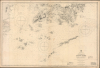
1888 / 1945 Admiralty Chart of Hong Kong Island and Environs, World War II


This item has been sold.
China-S.E. Coast Approaches to Hong Kong.
Occupied Hong Kong during World War II.
- Digital Map Information
- Suitable for large format printing
- Full resolution TIFF file
- ICC color profile embedded
- Delivered instantly via download link
Occupied Hong Kong during World War II.
This is an 1888 / 1945 British Admiralty World War II nautical chart or map of Hong Kong and the mouth of the Pearl River. Originally prepared in 1888, at the height of British imperial power, this edition, updated in print and manuscript, was the product of more challenging times, when the Japanese occupied Hong Kong during World War II (1939 - 1945).A Closer Look
This chart covers Hong Kong Island and the mouth of the Pearl River, here as 'Canton River (Chu Kiang)'. Macao appears at the top-left, while Hong Kong is covered from the southern part of the New Territories down through Hong Kong Island and to a group of mostly uninhabited islands south of Hong Kong and Macao, ending in Gap Rock (Wenweizhou, 蚊尾洲, literally 'the mosquito's tail') and Reef Island (Pingzhou, 平洲). Navigational information is provided in extensive detail throughout, including soundings, bottoms, currents, rocks, hazards, and shoals, along with three compass roses with magnetic variations and information on tides at the bottom right. On land, elevation is indicated along with areas of urban development on Hong Kong Island, Macao, and in Kowloon. Manuscript annotations appear around Tathong Point east of Hong Kong Island. In sum, this chart provides all the information a navigator would need to find a path through these tricky yet vitally important waterways.The Occupation of Hong Kong
During World War II, Hong Kong was under Imperial Japanese occupation, which began on December 25, 1941, following the city's surrender after 18 days of fierce fighting. The Battle of Hong Kong was among the first battles of the Pacific War, coinciding with the bombing of Pearl Harbor. Despite strong port-side defenses, Hong Kong's garrison, composed of British, Indian, and Canadian units, along with Auxiliary Defence Units and the Hong Kong Volunteer Defence Corps (HKVDC), was quickly overwhelmed, leading to the colony's surrender. The occupation lasted until the end of World War II (1939 - 1945), spanned 3 years and 8 months, and was marked by martial law and severe human rights abuses, including brutality, famine, malnourishment, and sickness in internment camps. (Macao, by contrast, remained neutral territory, though under increasing Japanese pressure and 'supervision' as the war went on.) The occupation of Hong Kong ended with the surrender of Japan following the dropping of the atomic bombs on Hiroshima and Nagasaki. British troops returned to Hong Kong on August 30, 1945.Publication History and Census
This chart was originally prepared by the British Admiralty in 1888, with the present map being the updated 1939 edition with minor additions up to 1942, and manuscript additions to 1945, presumably made at the very end of the war or just after. The OCLC records a small handful of examples of this map in various editions, with only the British Library holding a 1939 edition.Cartographer
The British Admiralty Office (1795 - Present) or the United Kingdom Hydrographic Office refers to the Branch of the English government that is responsible for the command of the British Navy. In 1795 King George III created the United Kingdom Hydrographic Office, known in short as the U.K.H.O., to provide top notch nautical charts to the vast Royal Navy. Prior the founding of the Admiralty the surveying and creation of nautical charts was primarily a commercial venture wherein the cartographer himself, more of than not, actually financed the printing of his own material. The great navigator Cook himself is known to have scrambled for funds to publish his own seminal charts - the most important and advanced of the period. The system of privately funded nautical mapping and publishing left vast portions of the world uncharted and many excellent charts unpublished. King George III, responding significant loss in trade revenue related to shipwrecks and delay due to poor charts, recognized the need for an institutionalized government sponsored cartographic agency - the Admiralty. The first head of the Admiralty, a position known as Hydrographer, was the important cartographer Alexander Dalrymple. Dalrymple started by organizing and cataloging obtainable charts before initiating the laborious process of updating them and filling in the blanks. The first official Admiralty Chart appeared in 1800 and detailed Quiberon Bay in Brittany. By 1808 the position of Hydrographer fell to Captain Thomas Hurd. Hurd advocated the sale of Admiralty charts to the general public and, by the time he retired in 1829, had issued and published some 736 charts. Stewardship of the organization then passed to Rear Admiral Sir Francis Beaufort. It was under Beaufort's administration that the Admiralty truly developed as a "chart making" as opposed to a "chart cataloging" institution. Beaufort held his post from 1829 to 1854. In his 25 years at the Admiralty Beaufort created nearly 1500 new charts and sponsored countless surveying and scientific expeditions - including the 1831 to 1836 voyage of the H.M.S. Beagle. By 1855 the Admiralty's chart catalog listed some 1,981 charts. Further Details...
Condition
Very good.
References
OCLC 1346518165.