
1950 Abdelmonem Educational Wall Map of Arabia and Environs

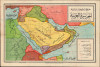
الْجَزِيرَةُ الْعَرَبِيَّةُ خَرِيطَةٌ طَبِيعِيَّةٌ سِيَاسِيَّةٌ / [The Arabian Peninsula A Physical and Political Map].
Saudi map of the Arab World in transition.
- Digital Map Information
- Suitable for large format printing
- Full resolution TIFF file
- ICC color profile embedded
- Delivered instantly via download link
Saudi map of the Arab World in transition.
This is a c. 1950 Mohamed Abdelmonem Arabic-language wall map of the Middle East, printed by the Egyptian Mustafa al-Babi al-Halabi and Sons Press. It is recorded as being approved by the 'Directorate of Education in the Kingdom of Saudi Arabia,' suggesting that it was intended for classroom use in the kingdom.A Closer Look
The map covers from the Mediterranean, Egypt, and Sudan in the west to Pakistan in the east, and from southern Turkey in the north to the Horn of Africa in the south, with countries and territories color-shaded for easy distinction. Cities and settlements are indicated throughout, along with motor roads, caravan routes, railways, rivers, mountains, and maritime routes. This map employs the phrase 'Persian Gulf' (الخليج الفارسي) rather than the 'Arabian Gulf' (خليج عربي), which would become common in the Arab world in the following decades.Historical Context
During World War II (1939 - 1945), the Middle East had served as a vital supply route, channeling regional oil reserves and other goods to the Allied War effort. But the immediate postwar period catalyzed a rapid unraveling of European colonial influence alongside profound territorial restructuring. The establishment of the Arab League in Cairo in 1945 signaled a rising tide of pan-Arab nationalism, coinciding with the withdrawal of French forces from Syria and Lebanon (1946) and the end of British oversight in Transjordan (1946). However, the center of gravity quickly shifted to Palestine following the 1947 U.N. Partition Plan and the termination of the British Mandate. The declaration of the State of Israel in May 1948 and the subsequent Arab-Israeli War resulted in an Israeli victory, the displacement of over 700,000 Palestinians (the Nakba), and deep political destabilization across neighboring nations. The trauma of defeat exposed the fragility of old-guard monarchies and pro-Western ruling elites, directly triggering a wave of military coups in Syria and culminating in the 1952 Egyptian Revolution led by Gamal Abdel Nasser, which permanently dismantled the British-backed monarchy and signaled the rise of anti-imperialist Arab nationalism.Publication History and Census
This map was prepared by one Mohamed Abdelmonem (مُحَمَّد عَبْدِ المُنْعِمِ), noted as a teacher at the Madrasat Tahdir al-Bu'uth Secondary School in Makkah (Mecca), around the year 1950. Text in the bottom margin indicates that the 'Directorate of Education in the Kingdom of Saudi Arabia decided to use this map in its schools,' suggesting its intended audience. Though the map is undated, the use of the term Directorate of Education (مُدِيرِيَّةُ المَعَارِفِ) (rather than the later Ministry of Education وزارة المعارف, established in 1954), and the term phrase 'Egyptian Sudan' (السودان المصري), help to date the map to the early 1950s or perhaps even a little earlier. Conversely, the appearance of Pakistan indicates a date of 1947 or later. The labelling of 'Italian Somaliland' (الصومال الإيطالي) is likely just an anachronism since the status of this territory was uncertain for several years after the Second World War.The map was 'printed at the expense of Al-Iqtisad Press (مَطْبَعَةِ الٱقْتِصَادِ بِمَكَّةَ) in Makkah Al-Mukarramah'; this printing press was one of several private printers active in the city in the mid-20th century in Mecca focusing on religious works. It was published by Mustafa al-Babi al-Halabi and Sons Press, a prominent Cairo-based publisher of educational works, including maps. We have been unable to locate any other examples of this map in institutional collections or on the market.
Cartographer
Mustafa Al-Babi Al-Halabi Press (مطبعة مصطفى البابي الحلبي ; 1859 - c. 1985) was a prominent publisher based in Cairo. The firm was founded in Cairo in 1859 as the al-Maymaniyya Press (المطبعة الميمنية) by Ahmed al-Halabi (أحمد الحلبي ; d. 1898), an immigrant from Syria. As al-Halabi had no sons, he asked for his nephews to travel from his hometown of al-Bab, near Aleppo, to join him in the publishing business. When Ahmed al-Halabi died in 1898, he was succeeded by Mustafa Al-Babi Al-Halabi (مصطفى البابي الحلبي), presumably a nephew. The firm maintained the name al-Maymaniyya Press until 1919, when it was merged with Mustafa Al-Babi Al-Halabi's other publishing house, Dar Ihya' al-Kutub al-Arabiyya (دار إحياء الكتب العربية) which had been founded by by Isa al-Babi al-Halabi (عيسى البابي الحلبي). The new company was called Mustafa Al-Babi Al-Halabi and Sons Bookstore and Printing House (شركة مكتبة ومطبعة مصطفى البابي الحلبي وأولاده). The company was among the most prominent Egyptian publishers of the early-mid 20th century, specializing in religious works, such as al-Tabari's Qur'anic exegeses and Al-Ghazali's The Revival of Religious Sciences. Further Details...
Condition
Very good. Light wear along original fold lines. Verso repair at a fold intersection. Slight loss at a fold intersection.