
1950 Al-Bajuri Wall Map of Arabia and Environs, Arab Lands

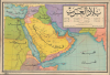

بلاد العرب / [Arab Lands].
Arab World in the Wake of World War II.
- Digital Map Information
- Suitable for large format printing
- Full resolution TIFF file
- ICC color profile embedded
- Delivered instantly via download link
Arab World in the Wake of World War II.
This is a rare c. 1950 Arabic-language wall map of the Arab World, prepared by Ahmed Al-Bajuri and published by Mustafa Al-Babi Al-Halabi and Sons. It presents the region in the wake of World War II (1939 - 1945), as European colonial empires collapsed and Arab nations gained independence.A Closer Look
Coverage embraces from Egypt and Sudan in the west to India in the east, taking in the Arabian Peninsula. A legend below the title at top-right indicates symbols for settlements of different sizes as well as borders, maritime shipping lines, wells, paved roads, caravan routes, railways (including the Hejaz Railway, though it had been non-operational for years), air routes, and oil fields. Major waterways (the Nile, the Suez Canal, the Tigris, and the Euphrates) are traced in black lines. Important early oil fields, such as Dhahran (الظهران) in Saudi Arabia and Burgan (برقان, indicated but not labeled) in Kuwait, are included. This map uses the term 'Persian Gulf' (الخليج الفارسي) rather than 'Arabian Gulf' (خليج عربي), which would become common in the Arab world in the following decades.The borders and placenames used are also curious and suggestive, perhaps reflecting the rapidly changing post-World War II situation. Not only British and French Somaliland but Italian Somaliland are maintained, perhaps also due to the recycling of older lithographic plates or laxity in updating placements in the aftermath of the war. The interior of Oman is just called Oman (عُمان) here, referring to the Sultanate of Oman, distinct from the coastal Sultanate of Muscat. This suggests that the map may predate the Jebel Akhdar War (1954 - 57), when the former was forcibly incorporated into the latter, though this is somewhat ambiguous, as Egyptian maps continued to reflect a divided Oman into the 1960s, as Egypt had opposed the merger. India and Pakistan are divided here, which more concretely reflects a date of 1947 or later. Also, while Jordan and Palestine are shaded the same color here, they are divided by a dashed red line, likely a reference to the post-1948 situation, formalized in 1950, when Jordan annexed the West Bank.
Historical Context
The map's title 'Bilād al-'Arab' (بلاد العرب) was a common phrase among pan-Arab nationalists, as in the movement's unofficial anthem 'The Arab Lands are My Homeland' (Bilād al-'Arab Awṭānī, بلاد العرب أوطاني). Pan-Arabism had roots in the late 19th-century Nahda intellectual movement, which helped strengthen a distinctly Arab identity separate from the Ottoman Empire, which ruled most of the Arab world, and from a wider global ummah. This identity found its most forceful expression in the Arab Revolt against the Ottomans during World War I (1914 - 1918) and the reaction to the British and French establishment of mandates and division of Arab lands in the post-World War I period, a betrayal of wartime promises for an autonomous and united Arab state. The increasingly tense situation in Palestine, with the arrival of large numbers of Jewish refugees with British tolerance, if not encouragement, further strengthened the Pan-Arab movement, which was formalized into the body of the Arab League in 1945. Following defeat in the First Arab-Israeli War in 1948 - 49, pan-Arabism took on a more revolutionary tone, flirting with socialism and seeing the region's existing monarchies as inept and irredeemable.Publication History and Census
This map was 'drawn and executed by artist Ahmed Al-Bajuri (رسم وتنفيذ الرسام أحمد الباجوري), about whom nothing is known but who presumably was a native of El Bagour (الباجور) in the Nile Delta in Northern Egypt. The map was published by Mustafa Al-Babi Al-Halabi and Sons (شركة مكتبة ومطبعة مصطفى البابي الحلبيوأولاده), a prominent publisher based in Cairo. The map is undated and assigning a date is complicated by the oddities and anachronisms mentioned above, but it most likely dates to c. 1950. There is a later edition of the map (also offered by us, ArabLands-albajuri-1950) that is larger in format but covers a slightly smaller geographical area. We have been unable to locate any other examples of either edition of the map in institutional collections or in market history.Cartographer
Mustafa Al-Babi Al-Halabi Press (مطبعة مصطفى البابي الحلبي ; 1859 - c. 1985) was a prominent publisher based in Cairo. The firm was founded in Cairo in 1859 as the al-Maymaniyya Press (المطبعة الميمنية) by Ahmed al-Halabi (أحمد الحلبي ; d. 1898), an immigrant from Syria. As al-Halabi had no sons, he asked for his nephews to travel from his hometown of al-Bab, near Aleppo, to join him in the publishing business. When Ahmed al-Halabi died in 1898, he was succeeded by Mustafa Al-Babi Al-Halabi (مصطفى البابي الحلبي), presumably a nephew. The firm maintained the name al-Maymaniyya Press until 1919, when it was merged with Mustafa Al-Babi Al-Halabi's other publishing house, Dar Ihya' al-Kutub al-Arabiyya (دار إحياء الكتب العربية) which had been founded by by Isa al-Babi al-Halabi (عيسى البابي الحلبي). The new company was called Mustafa Al-Babi Al-Halabi and Sons Bookstore and Printing House (شركة مكتبة ومطبعة مصطفى البابي الحلبي وأولاده). The company was among the most prominent Egyptian publishers of the early-mid 20th century, specializing in religious works, such as al-Tabari's Qur'anic exegeses and Al-Ghazali's The Revival of Religious Sciences. Further Details...
Condition
Good. Wear along original fold lines. Light soiling. Verso repairs at fold intersections. Closed tear extending .5 inch within printed area professionally repaired on verso.