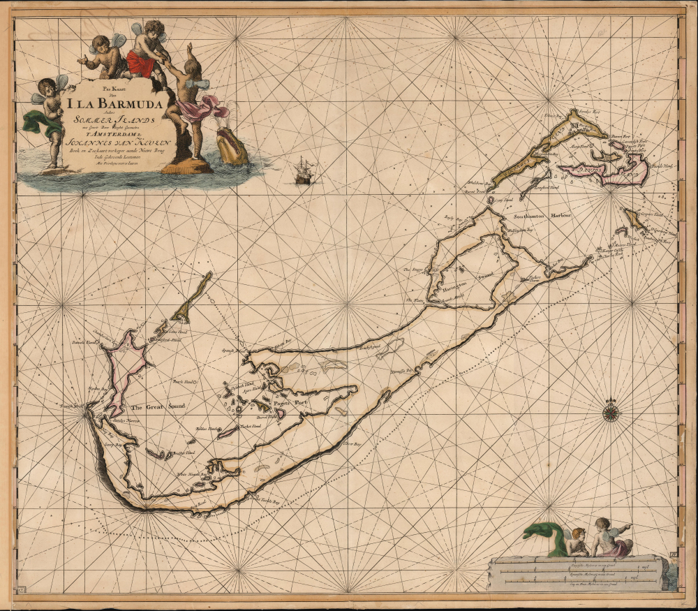
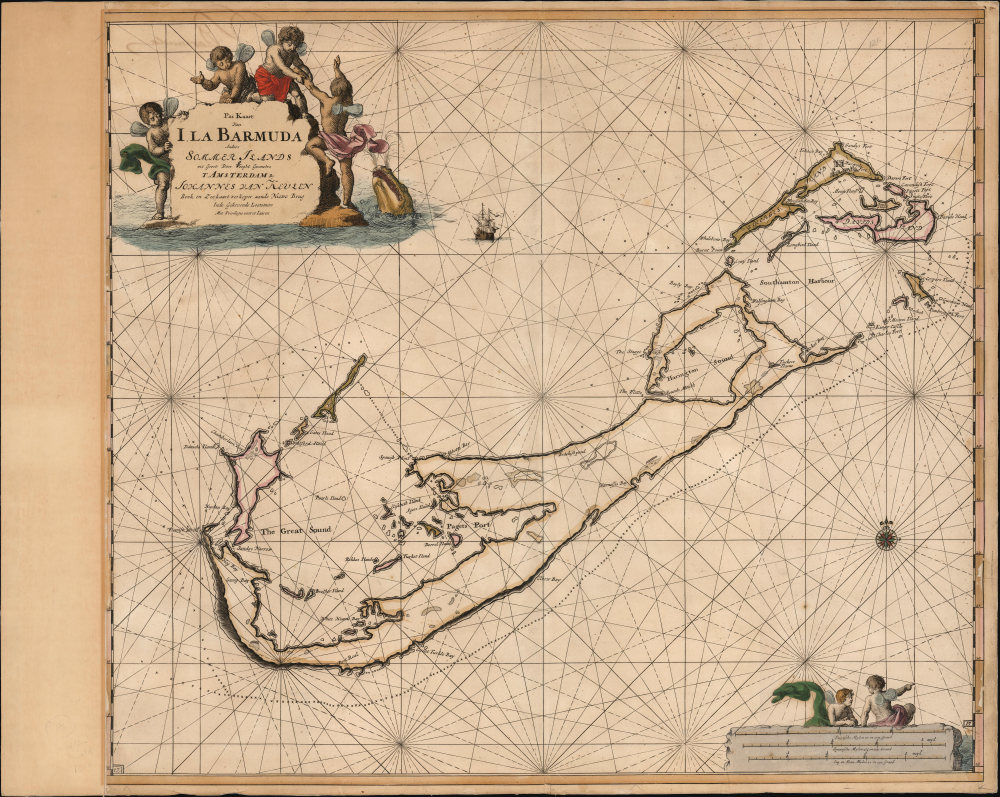
1684 / 1702 van Keulen Nautical Map of Bermuda
Bermuda-keulen-1684$5,000.00


Title
Pas Kaart van I. La Barmuda Anders Somer Islands int Groot Door Vooght Geometra.
1684 (undated) 20.5 x 23 in (52.07 x 58.42 cm) 1 : 52746
1684 (undated) 20.5 x 23 in (52.07 x 58.42 cm) 1 : 52746
Description
This is Johannes van Keulen's beautiful 1684 chart of Bermuda. This grand, desirable work is one of the earliest acquirable nautical charts of Bermuda; the present example is embellished with beautiful original color.
A Closer Look
This north-oriented chart presents the Bermudan archipelago in an up-to-date manner after the 1675 map of Arent Roggeveen (c.f. Geographicus: Bermuda-roggeveen-1685). A nautical chart, the map illustrates the coasts and seas well, with a particular focus on the reefs south of the islands. Van Keulen improves on Roggeveen's model by including significant inland military information, notably the symbols for the ring of forts guarding the entrances to Southampton Harbour at the northern extent of the archipelago. Both this and Roggeveen's chart followed the basic outline of the second survey of Richard Norwood (executed between 1663 and 1665), supplanting Norwood's own seminal survey of 1622. Despite its failings - notably the failure to illustrate the gauntlet of reefs, shoals, and rocks north of Bermuda - this model remained the dominant mapping of Bermuda until the 1738 Lemprière / Toms map.Waypoint of the Atlantic
This chart was published shortly after the governing Somers Island Company had lost its charter; thus it is the earliest chart produced after Bermuda had become a British Crown Colony.Publication History and Census
This chart was drawn by Claes Janszoon Vooght and engraved for inclusion in the fourth volume of van Keulen's 1684 De Nieuwe Groote Lightende Zee-Fakkel . This state of their Bermuda chart, with the plate numbers at lower left and lower right, appeared in the van Keulen sea atlases after 1702; it was replaced with an entirely new chart of the Bermudas in 1720. The chart is scarce: we see only two examples in institutional collections.CartographerS
Johannes Van Keulen (1654 – 1715) was a Dutch cartographer active in Amsterdam during the late 17th century. Van Keulen was the son of Lucas van Keulen. Van Keulen's firm, ‘In de Gekroonde Lootsman' (In the Crowned Pilot), was founded in 1678 and registered with the Amsterdam bookseller's guild as 'Cross staff-maker and bookseller.' (The cross-staff is a nautical instrument used to determine latitude.) Two years later, in 1680, they obtained a patent from the States General of Holland and West Friesland to publish nautical charts and atlases. Together with his partner, the cartographer Claes Janz Vooght, Van Keulen published numerous atlases and nautical charts, including the Zee Atlas and Nieuwe Lichtende Zee-Fakkel. It was a massive five-volume atlas containing more than 130 nautical charts. The Zee-Fakkel established the Van Keulen firm as the pre-eminent maker of Dutch sea charts in the late 17th and early 18th century. In 1714, one year before Johannes Van Keulen's death, his son, Gerard van Keulen (1678 - 1726), took charge. Gerard continued to update and republish the Zee-Fakkel until his own death in 1726. The firm was later passed on to Gerard's son, Johannes II Van Keulen (1704 - 1755), who significantly updated the atlas, especially with regard to Asia, issuing the 1753 4th Volume, known as the 'Secret Atlas'. The final editions of the atlas were published by Gerard Hulst van Keulen (1733 - 1801), Joannes II's son. The final true Van Keulen edition of the Zee-Fakkel was published posthumously in 1803. It is noteworthy that though ostensibly controlled by the Van Keulen men, it was the Van Keulen widows who maintained and managed the firm in the periods following their husbands' deaths. After the death of Gerard Hulst Van Keulen's son, Johannes Hulst Van Keulen, ownership of the family plates and business fell into the hands of the Swart family, who continued to publish until the company closed its doors 1885, ending a cartographic legacy spanning nearly 207 years. More by this mapmaker...
Richard Norwood (c.1590 – 1675) was an English mathematician, diver, and surveyor. He has been called 'Bermuda’s outstanding genius of the seventeenth century'. He had been sent to Bermuda by the Bermuda Company, not initially to survey the islands but to harvest pearls. Norwood had devised an early form of diving bell, with which he had succeeded in retrieving a cannon from Lymington Harbor, England. The Company hoped to employ Norwood's device to harvest pearls from the oyster beds they believed surrounded the islands. When a wealth of pearls failed to materialize, the Company instead reassigned Norwood to survey the islands, and he executed several surveys between 1614 and 1617. These would provide the basis of the dominant printed images of Bermuda of the seventeenth century, first published by Speed in 1622 and copied by Blaeu and Hondius. Despite accusations of collusion with the governor to assign to the governor and himself eight shares of the best land in the islands, he retained a long association with the place. Although he held land patents in Virginia, he does not seem to have ever travelled there, remaining instead in the Bermudas until the 1630s. He primarily made his living at that time in London as a teacher of mathematics, but continued geographical work, producing for example a sophisticated survey of the route between London and York. Using observations of the sun at various latitudes, he produced the most accurate estimation of the length of a degree of the meridian that had ever been done in England: his work would be noted by Newton in his Principia Mathematica. During the English Civil War he returned to Bermuda, there to work underr a government grant as a schoolmaster. He is credited with founding Bermuda's oldest school, Warwick Academy, in 1662; that same year he produced a further survery of the islands. He died at Bermuda in 1675, aged about eighty-five. Learn More...
Arent Roggeveen (1658 - November 27, 1679) was a Dutch hydrographer, cartographer, mathematician, poet, and astronomer active in the second half of the 17th century. Robgeveen was born in Delfshaven. Little is known of his education, but in 1658, he settled as a schoolmaster in Middleburg, seat of both the EIC and VOC. He later worked as a surveyor and a measurements expert in the wine industry - positions that made him reasonably wealthy. Around 1670, the VOC contracted him to compile and rectify their disparate archive of highly-secret sea charts. These were engraved and published in 1675 by Roggeveen and Pieter Goos. Roggeveen became obsessed with the notation of Terre Australis; a speculated continued occupying much of the southern hemisphere. In 1767, he received a patent from the Staten-Generaal to lead an expedition of discovery to the South Seas, but was unable to attract the necessary investment; it did not launch until the early 17th century, when his son, Jacob Roggeveen (1659 – 1729), made the voyage from 1721-22, in the process discovering Easter Island. Learn More...
Source
van Keulen, J., De Nieuwe Groote Lightende Zee-Fakkel, (Amsterdam: Keulen) c. 1702.
Nieuwe Lichtende Zee-Fakkel was the premier Dutch nautical atlas of the late 17th and 18th century. First introduced in 1681, over the course of its more than 100 years in production, the Zee-Fakkel expanded to six volumes. The first five volumes were published in Amsterdam by Johannes van Keulen (1654 - 1715). His son, Gerard van Keulen (1678 - 1726), reissued it in several editions with minor updates.
Grandson, Johannes II van Keulen (1704 - 1755) expanded the atlas in 1753 with Volume VI, illustrating Asian waters. This was a revolutionary addition. For three generations the Van Keulen's were the official cartographers of the VOC (Vereenigde Oostindische Compagnie / United Dutch East India Company). Until 1753, to protect their long-standing trade monopoly, the VOC jealously guarded their hydrographic data on East Asian waters, refusing the allow charts to be printed and requiring oaths of secrecy from the Van Keulens (and Bleaus before them). This led to dangerously inaccurate often contradictory charts. Thus, in 1744 Jan Harmenszoon de Marre (1696 - 1763), the VOC's Amsterdam Examiner, was instructed to work with van Keulen to publish compile, compare, and resolve the VOC's hoard of jealously guarded manuscript charts of East Asian waters. Johannes II and de Marre published the sixth volume of the Zee-Fakkel, focusing on Asian waters - if only for internal VOC use.
This was likely an attempt to consolidate and improve the general hydrography. Previously, VOC charts in manuscript were disseminated to ship captains on an as-needed basis, to be returned upon a voyage's completion. They were rarely compared or amended. A study of several VOC manuscript charts issued between 1720 and 1760 reveal striking disparities, likely resulting either from the charts being updated or copied from earlier less accurate charts. Such led to avoidable navigational and thus trade risks. A printed nautical atlas, whose hydrography was built upon the most recent and up-to-date charts, reassessed by the greatest chartmaker of the age, was a natural solution.
The new atlas, ostensibly an extension (Volume VI) of the existing commercially issued Nieuwe Lichtende Zee-Fakkel, was intended only for VOC use, and so became known as the 'Secret Atlas'. The printing run was extremely small, and access tightly controlled. VOC ship captains navigating to the Far East were given a copy on departure and expected to return it in good condition on return. Even so, the maps of the 'Secret Atlas' were disseminated, perhaps by the van Keulen's themselves. We note evidence of 'secret' Dutch hydrography in charts of the English Pilot as well as in other Dutch charts. Nonetheless, original maps from 'Secret' Zee-Fakkel volume VI remain of the utmost rarity.The firm passed to great-grandson Gerard Hulst van Keulen (1733 - 1801) under whose imprint the final 1803 van Keulen edition was published posthumously.
Grandson, Johannes II van Keulen (1704 - 1755) expanded the atlas in 1753 with Volume VI, illustrating Asian waters. This was a revolutionary addition. For three generations the Van Keulen's were the official cartographers of the VOC (Vereenigde Oostindische Compagnie / United Dutch East India Company). Until 1753, to protect their long-standing trade monopoly, the VOC jealously guarded their hydrographic data on East Asian waters, refusing the allow charts to be printed and requiring oaths of secrecy from the Van Keulens (and Bleaus before them). This led to dangerously inaccurate often contradictory charts. Thus, in 1744 Jan Harmenszoon de Marre (1696 - 1763), the VOC's Amsterdam Examiner, was instructed to work with van Keulen to publish compile, compare, and resolve the VOC's hoard of jealously guarded manuscript charts of East Asian waters. Johannes II and de Marre published the sixth volume of the Zee-Fakkel, focusing on Asian waters - if only for internal VOC use.
This was likely an attempt to consolidate and improve the general hydrography. Previously, VOC charts in manuscript were disseminated to ship captains on an as-needed basis, to be returned upon a voyage's completion. They were rarely compared or amended. A study of several VOC manuscript charts issued between 1720 and 1760 reveal striking disparities, likely resulting either from the charts being updated or copied from earlier less accurate charts. Such led to avoidable navigational and thus trade risks. A printed nautical atlas, whose hydrography was built upon the most recent and up-to-date charts, reassessed by the greatest chartmaker of the age, was a natural solution.
The new atlas, ostensibly an extension (Volume VI) of the existing commercially issued Nieuwe Lichtende Zee-Fakkel, was intended only for VOC use, and so became known as the 'Secret Atlas'. The printing run was extremely small, and access tightly controlled. VOC ship captains navigating to the Far East were given a copy on departure and expected to return it in good condition on return. Even so, the maps of the 'Secret Atlas' were disseminated, perhaps by the van Keulen's themselves. We note evidence of 'secret' Dutch hydrography in charts of the English Pilot as well as in other Dutch charts. Nonetheless, original maps from 'Secret' Zee-Fakkel volume VI remain of the utmost rarity.
Condition
Very good. Mends to oxidation loss in right margins; left margin extended with some loss to border. Original color.
References
OCLC: 431575275. Palmer, Printed Maps of Bermuda (Map Collectors Series 19), #15. Palmer, Printed Maps of Bermuda, p. 16. Koeman, Atlantes Neerlandici, IV, Keu.110A, (18) [132].