1718 Covens and Mortier / De l'Isle Map of the British Isles
BritishIsles-delisle-1718$500.00
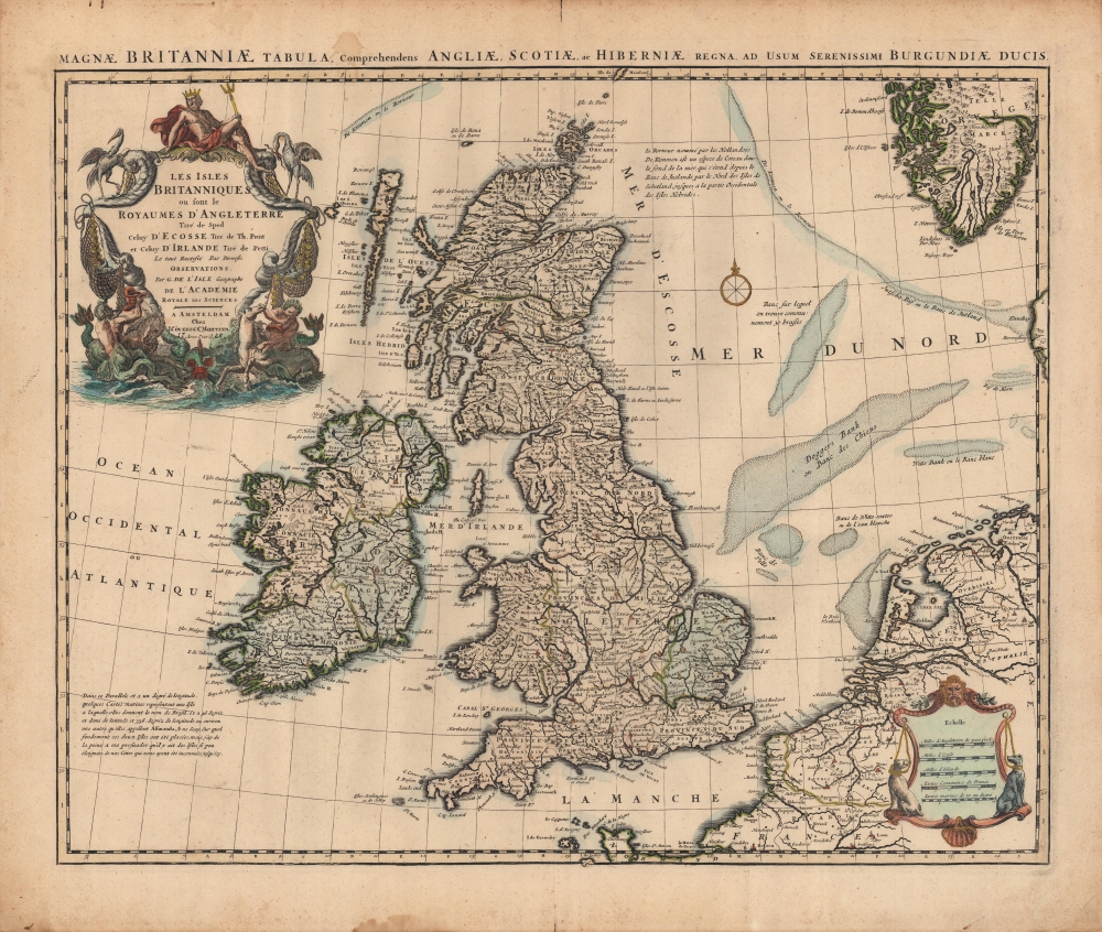

Title
Les Isles Britanniques ou sont le Rme d'Angleterre tiré de Sped, celuy d'Ecosse tiré de Th. Pont, etc. et celuy d'Irlande tiré de Petti. Le tout rectifié par diverses Observations.
1718 (undated) 18 x 22.5 in (45.72 x 57.15 cm) 1 : 2600000
1718 (undated) 18 x 22.5 in (45.72 x 57.15 cm) 1 : 2600000
Description
A c. 1718 example of Covens and Mortier's issue of De l'Isle's map of the British Isles. Combining terrestrial and maritime information in splendid detail, this example is also distinguished by old color, refreshed, and heightened with gold.
De l'Isle, being a careful and assiduous cartographer, provides explanatory notes for his exclusion of what he (correctly) deemed to be phantom islands off the coast of Ireland, and for his inclusion of the 'Kimmen Line' in the North Sea, which he calls 'a kind of hill at the bottom of the sea' (the boundary of the British and Norwegian Continental Shelves). Other relatively shallow banks in the North Sea and English Channel are noted.
Longitude is measured from the Ferro Meridian. Five scales are provided at bottom-right. Aside from the addition of gold, the title cartouche adds flourish to the map, with illustrations of Poseidon, birds, fish, and mermen.
From the original De l'Isle map, Covens and Mortier made only minor modifications, removing the name of the engraver (Jean-Baptiste Liébaux) in the title cartouche to add their own, adding the Latin text at top, and reducing (almost entirely removing) a portion of Denmark and the text 'Allemagne' at bottom-right. This issue of the map is surprisingly scarce, only being noted among the holdings of the Library of Congress, while earlier (1702) and later (1745, Buache; 1772, Dezauche) editions are also only held by a small handful of institutions.
A Closer Look
Covering England, Wales, Scotland, and Ireland, De l'Isle's map also takes in portions of northern France, the Low Countries, and the coast of Norway. Scotland, Wales, and the counties of Ireland are outlined in hand-color. Less distinct lines mark out English 'Provinces du nord,' 'Provinces du sud,' and so on, though the 'Provinces de l'est' are noticeably shaded in green. Larger cities are denoted with a red dot, some of which have been painted over with a gold dot.De l'Isle, being a careful and assiduous cartographer, provides explanatory notes for his exclusion of what he (correctly) deemed to be phantom islands off the coast of Ireland, and for his inclusion of the 'Kimmen Line' in the North Sea, which he calls 'a kind of hill at the bottom of the sea' (the boundary of the British and Norwegian Continental Shelves). Other relatively shallow banks in the North Sea and English Channel are noted.
Longitude is measured from the Ferro Meridian. Five scales are provided at bottom-right. Aside from the addition of gold, the title cartouche adds flourish to the map, with illustrations of Poseidon, birds, fish, and mermen.
Publication History and Census
This map was originally produced in Paris by the De l'Isle family c. 1702 (Rumsey 4764.008); as the subtitle indicates, De l'Isle drew on John Speed, Timothy Pont, and William Petty to produce his map. This example was engraved in Amsterdam by Mortier and published by Covens and Mortier, with whom the De l'Isles had a publishing agreement. Though the date of 1725 is written in, this appears to be a later addition and cannot be fully relied upon. De l'Isle's official title here - 'géographe de l'académie royale des sciences' - would seem to indicate a date between 1702 and 1718 but might have been carried over beyond this date on the Covens and Mortier plate. In any event, the map likely dates no later than 1730.From the original De l'Isle map, Covens and Mortier made only minor modifications, removing the name of the engraver (Jean-Baptiste Liébaux) in the title cartouche to add their own, adding the Latin text at top, and reducing (almost entirely removing) a portion of Denmark and the text 'Allemagne' at bottom-right. This issue of the map is surprisingly scarce, only being noted among the holdings of the Library of Congress, while earlier (1702) and later (1745, Buache; 1772, Dezauche) editions are also only held by a small handful of institutions.
CartographerS
The De L'Isle family (fl. c. 1700 - c. 1760) (also written Delisle) were, in composite, a mapmaking tour de force who redefined early 18th century European cartography. Claude De L'Isle (1644 -1720), the family patriarch, was Paris based a historian and geographer under Nicholas Sanson. De L'Isle and his sons were proponents of the school of "positive geography" and were definitive figures, defining the heights of the Golden Age of French Cartography. Of his twelve sons, four, Guillaume (1675 - 1726), Simon Claude (1675 - 1726), Joseph Nicholas (1688 - 1768) and Louis (1720 - 1745), made a significant contributions to cartography. Without a doubt Guillaume was the most remarkable member of the family. It is said that Guillaume's skill as a cartographer was so prodigious that he drew his first map at just nine years of age. He was tutored by J. D. Cassini in astronomy, science, mathematics and cartography. By applying these diverse disciplines to the vast stores of information provided by 18th century navigators, Guillaume created the technique that came to be known as "scientific cartography", essentially an extension of Sanson's "positive geography". This revolutionary approach transformed the field of cartography and created a more accurate picture of the world. Among Guillaume's many firsts are the first naming of Texas, the first correct map of the Mississippi, the final rejection of the insular California fallacy, and the first identification of the correct longitudes of America. Stylistically De L'Isle also initiated important changes to the medium, eschewing the flamboyant Dutch style of the previous century in favor of a highly detailed yet still decorative approach that yielded map both beautiful and informative. Guillaume was elected to the French Academie Royale des Sciences at 27. Later, in 1718, he was also appointed "Premier Geographe du Roi", an office created especially for him. De L'Isle personally financed the publication of most of his maps, hoping to make heavy royalties on their sales. Unfortunately he met an untimely death in 1728, leaving considerable debt and an impoverished child and widow. De L'Isle's publishing firm was taken over by his assistant, Phillipe Buache who became, posthumously, his son in law. The other De L'Isle brothers, Joseph Nicholas and Louis De L'Isle, were employed in the Service of Peter the Great of Russia as astronomers and surveyors. They are responsible for cataloguing and compiling the data obtained from Russian expeditions in the Pacific and along the northwest coast of America, including the seminal explorations of Vitus Bering and Aleksei Chirikov. The De L'Isles, like their rivals the Vaugondys , must be considered speculative geographers. Speculative geography was a genre of mapmaking that evolved in Europe, particularly Paris, in the middle to late 18th century. Cartographers in this genre would fill in unknown areas on their maps with speculations based upon their vast knowledge of cartography, personal geographical theories, and often dubious primary source material gathered by explorers and navigators. This approach, which attempted to use the known to validate the unknown, naturally engendered many rivalries. The era of speculatively cartography effectively ended with the late 18th century explorations of Captain Cook, Jean Francois de Galaup de La Perouse, and George Vancouver. More by this mapmaker...
Covens and Mortier (1721 - c. 1862) was an Amsterdam publishing firm, the successor to the extensive publishing empire built by Pierre Mortier (1661 - 1711). Covens and Mortier maps are often criticized as derivative - but this is not fully the case. Pierre Mortier lived in Paris from 1681 to 1685. There he established close relationships the the greatest French cartographers of the era, including De L'Isle and D'Anville. His business model was based upon leveraging Dutch printing technology and sophistication to co-publish state of the art French cartography. Upon Mortier's death in 1711 his firm was taken over by his son, Cornelius Mortier (1699 - 1783). Cornelius married the sister of Johannes Covens (1697 - 1774) in 1721 and, partnering with his brother in law, established the Covens and Mortier firm. Under the Covens and Mortier imprint, Cornelius and Johannes continued in Pierre's model of publishing the most up-to-date French works with permission. They quickly became one of the largest and most prolific Dutch publishing concerns of the 18th century. The firm and its successors published thousands of maps over a 120 year period from 1721 to the mid-1800s. During their long lifespan the Covens and Mortier firm published as Covens and Mortier (1721 - 1778), J. Covens and Son (1778 - 94) and Mortier, Covens and Son (1794 - c. 1862). Learn More...
John Speed (1542 - 1629) was an important English historian and cartographer active in the early 17th century. Speed was born in Fardon, Cheshire and apprenticed under his father as a tailor. Though his heart was never in tailoring, Speed dedicated himself to this profession until he was about 50 years old. During all the time, Speed dedicated his spare time to research as amateur historian and mapmaker - even preparing several maps for Queen Elizabeth. In London, Speed's interest in history lead him to join the Society of Antiquaries. Eventually he befriended the wealthy Sir Fulke Greville, who sponsored his researches and eventually freed him from the haberdashery profession. Working with William Camden, Speed eventually published his 1611 Historie of Great Britaine. Though this history itself was amateurish and of minimal importance, Speed's inclusion of numerous maps of British Cities and town was seminal. In many cases these plans were the first maps ever issued of their respective subjects. Later, turning his attention more fully to Geography, Speed published the magnificent atlas Theatre of the Empire of Great Britaine and, just prior to his death, the 1627 A Prospect of the Most Famous Parts of the World. These were the first British world atlases and have a landmark position in the history of cartography. These atlases continued to be published well after Speed's death. Learn More...
Condition
Very good. Minor splitting at fold in margins, with centerfold mend at bottom margin. Old color, refreshed and heightened with gold. Sporadic water staining.
References
OCLC 67517151. Tooley, R.V., The Mapping of America (London: The Holland Press, 1985), 5-6. Pool. J, 'The Kimmen Line: Seventeenth-Century North Atlantic Navigation and the Continental Shelf' Terrae Incognitae: The Journal of the Society for the History of Discoveries 38:1 (2006), 26-35.