
This item below is out of stock, but another example (left) is available. To view the available item, click "Details."
Details
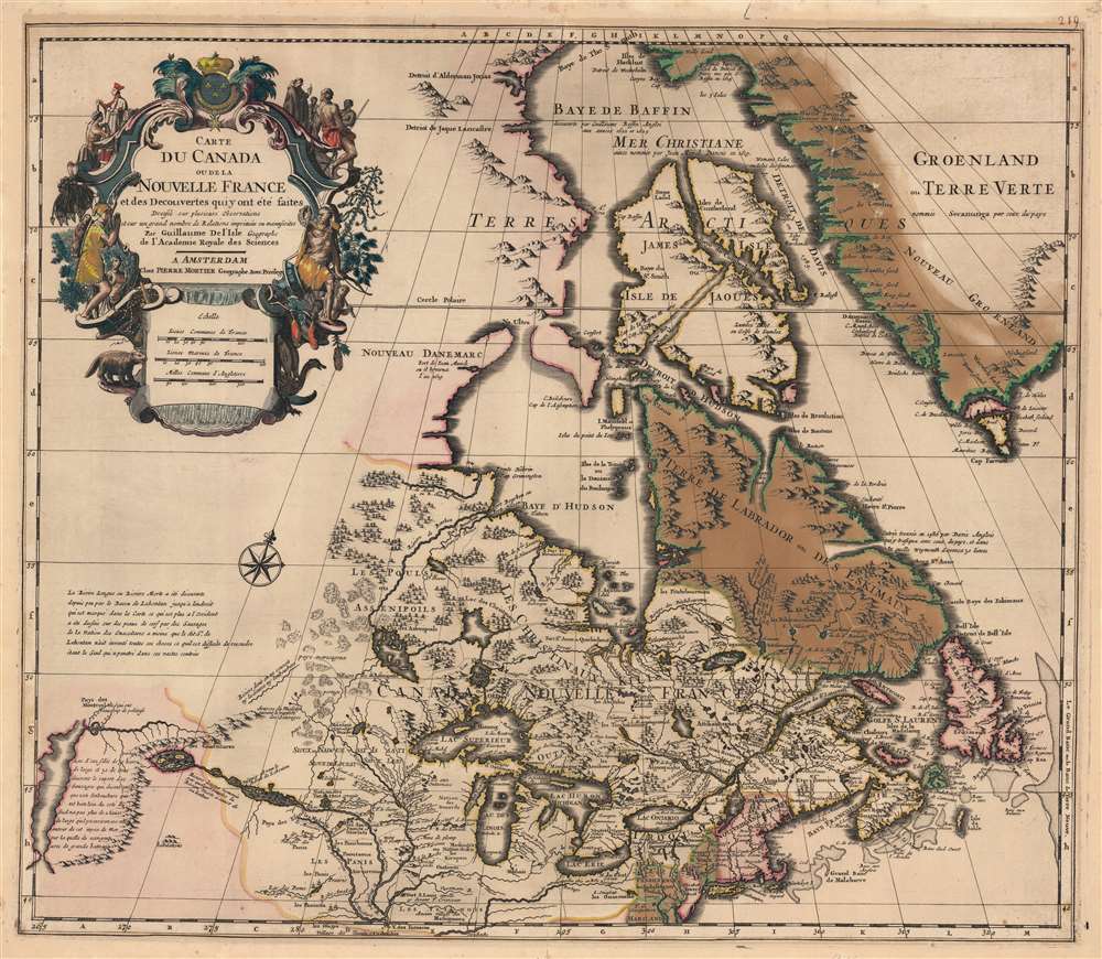
1718 De L'Isle Map of Canada, the Great Lakes, and New England
1703 (dated) $1,800.00
1708 De L'Isle / Mortier Map of Canada, the Great Lakes, and New England
CarteduCanada-delislemortier-1708$1,400.00

Title
Carte du Canada ou de la Nouvelle France et des Decouverts qui y ont été faites...
1708 (undated) 20 x 26 in (50.8 x 66.04 cm) 1 : 5400000
1708 (undated) 20 x 26 in (50.8 x 66.04 cm) 1 : 5400000
Description
This is the 1708 Pierre Mortier old-color issue of Guillaume de l'Isle's map of northern North America - one of the most important and influential maps of this region.
Lahontan's work has been both dismissed as fancy and defended as erroneous speculation by various scholars. Could Lahontan have been describing indigenous reports of the Great Salt Lake? What river was he on? Perhaps we will never know.
On his return to Europe, Lahonton published his travels in an enormously popular 1703 book that influences the most important cartographers of his day: Moll, De L'Isle, Popple, Sanson, and Chatelain to name just a few. Both the Longue River and the saline sea beyond were included in numerous maps.
The suggestion of an inland river passage to the Pacific fired the imagination of the French and English, who were aggressively searching for just such a route. Unlike the Spanish, with easy access to the Pacific through the narrow isthmus of Mexico and the Port of Acapulco, the French and English had no practical route by which to offer their furs and other commodities to the affluent markets of Asia. A passage such as Lahontan suggested was just what was needed and wishful thinking more than factual exploration fueled the inclusion of Lahontan's speculations on this and many other maps. De L'Isle, to his credit, expresses doubt about Lahontan's discoveries noting:
A Closer Look
The map covers the United States north of the Chesapeake and Canada or New France, including all five of the Great Lakes and Hudson Bay in full. De l'Isle first issued this map in 1703. At the time, it was the most sophisticated cartographic representation of this region yet published, referencing various elements from the most recent explorations including the Jesuit Relations, Pierre Le Moyne d'Ibervile, Pierre Le Sour, and Baron de Lahontan. The present edition, published in Amsterdam by Pierre Mortier c. 1708, is the first Dutch edition. A decorative title cartouche in the upper left features stylized New World fauna, including a beaver, and missionaries converting American Indians.Kershaw's Praise
According to the map historian Kenneth Andrew Kershaw, this isOne of the most outstanding maps of Canada of the 17th and early 18th centuries . . . De l'Isle's careful research resulted in the first map of Canada to present the whole of the Great Lakes correctly. In addition, the position of the lakes relative to Hudson's Bay is also correct, and the Avalon Peninsula is shown much more realistically than on previous maps of Canada. Of considerable significance, the geography of the coastal regions of James and Hudson Bays, together with their major rivers systems, is presented by De l'Isle with a surprising degree of accuracy.
Baron Louis Armand de Lahontan
One of this map's most intriguing elements is De L'Isle's treatment of the speculative explorations of the Baron Louis Armand de Lahontan, which dominate the lower left quadrant. Lahontan (1666 - 1715) was a French military officer commanding the fort of St. Joseph, near modern day Port Huron, Michigan. Abandoning his post to live and travel with local Chippewa tribes, Lahontan claims to have explored much of the Upper Mississippi Valley and discovered a heretofore unknown river, which he dubbed the 'Longue River'. This river he claims to have followed a good distance from its convergence with the Mississippi. Beyond the point where he himself traveled, Lahontan wrote of further lands along the river described by his American Indian guides. These include a great saline lake or sea (ghosted in here) at the base of a low mountain range. This range, he reported, could be easily crossed and from this point further rivers flowed westward to the mysterious lands of the Mozeemleck, and presumably the Pacific.Lahontan's work has been both dismissed as fancy and defended as erroneous speculation by various scholars. Could Lahontan have been describing indigenous reports of the Great Salt Lake? What river was he on? Perhaps we will never know.
On his return to Europe, Lahonton published his travels in an enormously popular 1703 book that influences the most important cartographers of his day: Moll, De L'Isle, Popple, Sanson, and Chatelain to name just a few. Both the Longue River and the saline sea beyond were included in numerous maps.
The suggestion of an inland river passage to the Pacific fired the imagination of the French and English, who were aggressively searching for just such a route. Unlike the Spanish, with easy access to the Pacific through the narrow isthmus of Mexico and the Port of Acapulco, the French and English had no practical route by which to offer their furs and other commodities to the affluent markets of Asia. A passage such as Lahontan suggested was just what was needed and wishful thinking more than factual exploration fueled the inclusion of Lahontan's speculations on this and many other maps. De L'Isle, to his credit, expresses doubt about Lahontan's discoveries noting:
Lahontan n'ait inventé toutes ces choses ce qu'il est difficile de resoudre étant le Seul qui a penetré dans ces vastes contrées.This map proved highly influential and was one of the best maps of this region until the explorations of late 18th and early 19th century.
Lahontan [may have] invented all of these things, which is difficult to resolve as he was the only one to visit these vast lands. [our own translation]
Publication History and Census
This map was compiled by Guillaume de l'Isle who first published it in 1703. It had a long lifespan and was copied and updated by multiple publishes including c. 1708 by Pierre Mortier (current example), in 1730 by Mortier's heirs 'Covens and Mortier', in 1745 by Phillipe Buache (1700 - 1773), and in 1781 by Jean-Claude Dezauche (1745 - 1824). The present edition is undated, but can only have been published in Pierre Mortier's lifetime, which means before 1710/11. Mortier maintained close ties with de l'Isle and thus this map's publication in Amsterdam proceeded with de l'Isle's knowledge and blessing - it was a partnership, not a piracy. Kershaw was unable to identify any atlas publications of this map in the Pierre Mortier edition, suggesting it was a separate issue. He nonetheless notes that the companion de l'Isle map of North America, also bearing the Mortier imprint, definitively appears in 1708 - thus the date here. This edition thus represents the first Mortier issue, or Kershaw 205a. This edition is among the earliest examples of the present map, predating all other examples except the 1703 de l'Isle first state (Kershaw 202a). We note very few examples of this edition in institutional collections and no market history.CartographerS
The De L'Isle family (fl. c. 1700 - c. 1760) (also written Delisle) were, in composite, a mapmaking tour de force who redefined early 18th century European cartography. Claude De L'Isle (1644 -1720), the family patriarch, was Paris based a historian and geographer under Nicholas Sanson. De L'Isle and his sons were proponents of the school of "positive geography" and were definitive figures, defining the heights of the Golden Age of French Cartography. Of his twelve sons, four, Guillaume (1675 - 1726), Simon Claude (1675 - 1726), Joseph Nicholas (1688 - 1768) and Louis (1720 - 1745), made a significant contributions to cartography. Without a doubt Guillaume was the most remarkable member of the family. It is said that Guillaume's skill as a cartographer was so prodigious that he drew his first map at just nine years of age. He was tutored by J. D. Cassini in astronomy, science, mathematics and cartography. By applying these diverse disciplines to the vast stores of information provided by 18th century navigators, Guillaume created the technique that came to be known as "scientific cartography", essentially an extension of Sanson's "positive geography". This revolutionary approach transformed the field of cartography and created a more accurate picture of the world. Among Guillaume's many firsts are the first naming of Texas, the first correct map of the Mississippi, the final rejection of the insular California fallacy, and the first identification of the correct longitudes of America. Stylistically De L'Isle also initiated important changes to the medium, eschewing the flamboyant Dutch style of the previous century in favor of a highly detailed yet still decorative approach that yielded map both beautiful and informative. Guillaume was elected to the French Academie Royale des Sciences at 27. Later, in 1718, he was also appointed "Premier Geographe du Roi", an office created especially for him. De L'Isle personally financed the publication of most of his maps, hoping to make heavy royalties on their sales. Unfortunately he met an untimely death in 1728, leaving considerable debt and an impoverished child and widow. De L'Isle's publishing firm was taken over by his assistant, Phillipe Buache who became, posthumously, his son in law. The other De L'Isle brothers, Joseph Nicholas and Louis De L'Isle, were employed in the Service of Peter the Great of Russia as astronomers and surveyors. They are responsible for cataloguing and compiling the data obtained from Russian expeditions in the Pacific and along the northwest coast of America, including the seminal explorations of Vitus Bering and Aleksei Chirikov. The De L'Isles, like their rivals the Vaugondys , must be considered speculative geographers. Speculative geography was a genre of mapmaking that evolved in Europe, particularly Paris, in the middle to late 18th century. Cartographers in this genre would fill in unknown areas on their maps with speculations based upon their vast knowledge of cartography, personal geographical theories, and often dubious primary source material gathered by explorers and navigators. This approach, which attempted to use the known to validate the unknown, naturally engendered many rivalries. The era of speculatively cartography effectively ended with the late 18th century explorations of Captain Cook, Jean Francois de Galaup de La Perouse, and George Vancouver. More by this mapmaker...
Pierre Mortier (January 26, 1661 - February 18, 1711) or Pieter Mortier was a cartographer, engraver, and print seller active in Amsterdam during the later 17th and early 18th centuries. Mortier, then known as Pieter, was born in Leiden. He relocated to Paris from 1681 to 1685, adopting the French name Pierre, which he retained throughout his career. While in France, he developed deep French connections by bringing sophisticated Dutch printing technology and experience to nascent French map publishers such as Guillaume De L'Isle (1675 - 1726), Alexis-Hubert Jaillot (c. 1632 - 1712), and Nicholas de Fer (1646 - 1720). Consequently, much of Mortier's business was built upon issuing embellished high quality editions of contemporary French maps - generally with the permissions of their original authors. In the greater context of global cartography, this was a significant advantage as most Dutch map publishes had, at this point, fallen into the miasma of reprinting their own outdated works. By contrast, the cartographers of France were producing the most accurate and up to date charts anywhere. Mortier's cartographic work culminated in the magnificent nautical atlas, Le Neptune Francois. He was awarded the Privilege, an early form of copyright, in 1690. Upon Pierre's death in 1711 this business was inherited by his widow. In 1721, his son Cornelius Mortier took over the day to day operation of the firm. Cornelius partnered with his brother-in-law Jean Covens to form one of history's great cartographic partnerships - Covens and Mortier - which continued to publish maps and atlases until about 1866. Learn More...
Condition
Very good. Old original color. Some greens oxidized in Greenland and Labrador - leading to cracking of paper. These have led the entire map to be stabilized on archival tissue. Marginal foxing.
References
OCLC 1056970776. Tooley, R. V., The Mapping of America, p. 20-1, #42. Kershaw, K. A., Early Printed Maps of Canada, #205a. Karpinski, L. C., Bibliography of the Printed Maps of Michigan, 1804-1880, p. 40, 47. Schwartz, S. and Ehrenberg, R., The Mapping of America, pl. 80.