This item has been sold, but you can get on the Waitlist to be notified if another example becomes available, or purchase a digital scan.
1609 Mercator and Hondius Map of Ceylon or Sri Lanka
Ceilan-mercator-1609$500.00

Title
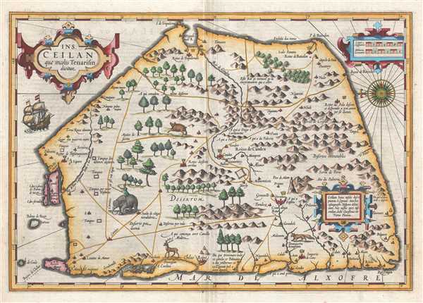
Ins. Ceilan quae incolis Tenarisin dicitur.
1609 (undated) 14 x 20 in (35.56 x 50.8 cm) 1 : 980000
1609 (undated) 14 x 20 in (35.56 x 50.8 cm) 1 : 980000
Description
This is a 1609 Gerard Mercator and Jodocus Hondius map of Sri Lanka. The map, which is oriented from the east, depicts the entire island. Cartographically it remains vaguely defined in an unusual five-sided form – indicative of the limited understanding of this region in the 1600s. A key component in the spice trade, trading bazaars in India and Sri Lanka exposed the Western world to the spices of the East. Although trade in spices had been ongoing since before the Christian era, the advent of the European Age of Discovery completely changed the spice trade. Portuguese explorer Vasco da Gama, pioneered a sea route around the Cape of Good Hope, which opened the age of European dominance in the East.
Beautifully illustrated, the exotic stereotypes about Sri Lanka of 17th century Europe are apparent, as forests and mountains cover the island. Several different animals are illustrated on the map as well: a stag, a boar, a fox, and an elephant being ridden by a man. Numerous different cities and towns are labeled throughout, including several that have crowns drawn above them, indicating that they are Kingdoms. A decorative compass rose is situated along the right border, along with a decorative scale cartouche. A decorative title cartouche is located in the upper left corner, along with a sailing ship, with a third cartouche bearing a short Latin text in the lower right corner. Known as Portuguese Ceylon by 1609, the Portuguese maintained a presence in Sri Lanka from 1505 until 1658. Direct rule of the island by the Portuguese did not begin until after the death of Dharmapala of Kotte in 1580. Because he died without an heir, he bequeathed his kingdom to the Portuguese monarch. Portuguese rule of Sri Lanka was ceded to the Netherlands in 1658.
This map was drawn by Gerard Mercator, engraved by Petrus Plancius, and published by Jodocus Hondius in 1609.
CartographerS
Gerard Mercator (March 5, 1512 - December 2, 1594) is a seminal figure in the history of cartography. Mercator was born near Antwerp as Gerard de Cremere in Rupelmonde. He studied Latin, mathematics, and religion in Rupelmonde before his Uncle, Gisbert, a priest, arranged for him to be sent to Hertogenbosch to study under the Brothers of the Common Life. There he was taught by the celebrated Dutch humanist Georgius Macropedius (Joris van Lanckvelt; April 1487 - July 1558). It was there that he changed him name, adapting the Latin term for 'Merchant', that is 'Mercator'. He went on to study at the University of Louvain. After some time, he left Louvain to travel extensively, but returned in 1534 to study mathematics under Gemma Frisius (1508 - 1555). He produced his first world map in 1538 - notable as being the first to represent North America stretching from the Arctic to the southern polar regions. This impressive work earned him the patronage of the Emperor Charles V, for whom along with Van der Heyden and Gemma Frisius, he constructed a terrestrial globe. He then produced an important 1541 globe - the first to offer rhumb lines. Despite growing fame and imperial patronage, Mercator was accused of heresy and in 1552. His accusations were partially due to his Protestant faith, and partly due to his travels, which aroused suspicion. After being released from prison with the support of the University of Louvain, he resumed his cartographic work. It was during this period that he became a close fried to English polymath John Dee (1527 - 1609), who arrived in Louvain in 1548, and with whom Mercator maintained a lifelong correspondence. In 1552, Mercator set himself up as a cartographer in Duisburg and began work on his revised edition of Ptolemy's Geographia. He also taught mathematics in Duisburg from 1559 to 1562. In 1564, he became the Court Cosmographer to Duke Wilhelm of Cleve. During this period, he began to perfect the novel projection for which he is best remembered. The 'Mercator Projection' was first used in 1569 for a massive world map on 18 sheets. On May 5, 1590 Mercator had a stroke which left him paralyzed on his left side. He slowly recovered but suffered frustration at his inability to continue making maps. By 1592, he recovered enough that he was able to work again but by that time he was losing his vision. He had a second stroke near the end of 1593, after which he briefly lost speech. He recovered some power of speech before a third stroke marked his end. Following Mercator's death his descendants, particularly his youngest son Rumold (1541 - December 31, 1599) completed many of his maps and in 1595, published his Atlas. Nonetheless, lacking their father's drive and genius, the firm but languished under heavy competition from Abraham Ortelius. It was not until Mercator's plates were purchased and republished (Mercator / Hondius) by Henricus Hondius II (1597 - 1651) and Jan Jansson (1588 - 1664) that his position as the preeminent cartographer of the age was re-established. More by this mapmaker...
Jodocus Hondius (October, 14 1563 - February 12, 1612) was an important Dutch cartographer active in the late 16th and early 17th centuries. His common name, Jodocus Hondius is actually a Latinized version of his Dutch name, Joost de Hondt. He is also sometimes referred to as Jodocus Hondius the Elder to distinguish him from his sons. Hondius was a Flemish artist, engraver, and cartographer. He is best known for his early maps of the New World and Europe, for re-establishing the reputation of the work of Gerard Mercator, and for his portraits of Francis Drake. Hondius was born and raised in Ghent. In his early years he established himself as an engraver, instrument maker and globe maker. In 1584 he moved to London to escape religious difficulties in Flanders. During his stay in England, Hondius was instrumental in publicizing the work of Francis Drake, who had made a circumnavigation of the world in the late 1570s. In particular, in 1589 Hondius produced a now famous map of the cove of New Albion, where Drake briefly established a settlement on the west coast of North America. Hondius' map was based on journal and eyewitness accounts of the trip and has long fueled speculation about the precise location of Drake's landing, which has not yet been firmly established by historians. Hondius is also thought to be the artist of several well-known portraits of Drake that are now in the National Portrait Gallery in London. In 1593, Hondius returned to Amsterdam, where he remained until the end of his life. In 1604, he purchased the plates of Gerard Mercator's Atlas from Mercator's grandson. Mercator's work had languished in comparison to the rival atlas, Theatrum Orbis Terrarum by Ortelius. Hondius republished Mercator's work with 36 additional maps, including several which he himself produced. Despite the addition of his own contributions, Hondius recognizing the prestige of Mercator's name, gave Mercator full credit as the author of the work, listing himself as the publisher. Hondius' new edition of Mercator revived the great cartographer's reputation and was a great success, selling out after a year. Hondius later published a second edition, as well as a pocket version called the Atlas Minor. The maps have since become known as the "Mercator/Hondius series". Between 1605 and 1610 Hondius was employed by John Speed to engrave the plates for Speed's The Theatre of the Empire of Great Britaine. Following Hondius' death in 1612, his publishing work in Amsterdam was continued by his widow and two sons, Jodocus II and Henricus. Later his family formed a partnership with Jan Jansson, whose name appears on the Atlasas co-publisher after 1633. Eventually, starting with the first 1606 edition in Latin, about 50 editions of the Atlas were released in the main European languages. In the Islamic world, the atlas was partially translated by the Turkish scholar Katip Çelebi. The series is sometimes called the 'Mercator/Hondius/Jansson' series because of Jansson's later contributions. Hondius' is also credited with a number of important cartographic innovations including the introduction of decorative map borders and contributions to the evolution of 17th century Dutch wall maps. The work of Hondius was essential to the establishment Amsterdam as the center of cartography in Europe in the 17th century. Learn More...
Petrus Plancius (1522 - May 15, 1622) was a Dutch-Flemish cartographer, astronomer, and clergyman. Born in Dranouter, he studied theology in Germany and England. He became a minister in the Dutch Reformed Church at the age of 24. In 1585, fearing religious prosecution by the Inquisition after Brussels fell into Spanish hands, Plancius fled to Amsterdam. It was in Amsterdam that he became interested in navigation and cartography and soon became a recognized expert on the shipping routes to India. Plancius published his best known world map in 1592, entitled ‘Nova et exacta Terrarum Tabula geographic et hydrographica’. Plancius was also one of the founders of the Dutch East India Company, for which he drew over 100 maps. Learn More...
Condition
Very good. Light wear and toning along original centerfold. Blank on verso.
References
OCLC 159839640.