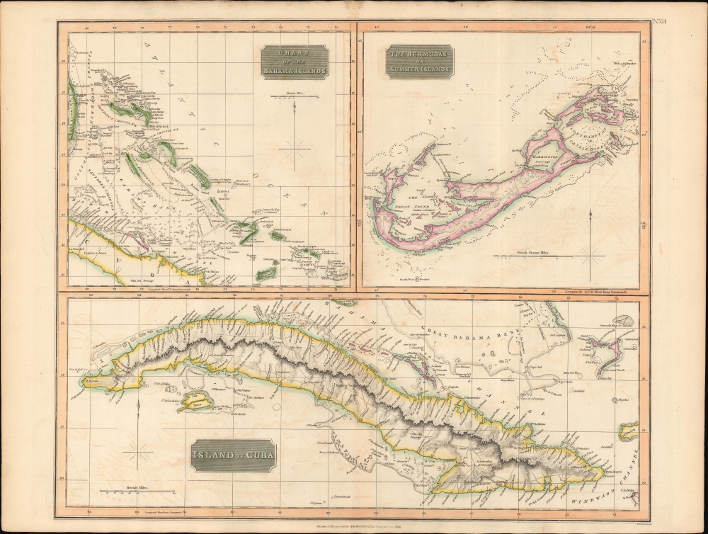
1816 Thomson Map of Cuba, Bermuda, and the Bahamas
Cuba-thomson-1816$600.00

Title
Island of Cuba. / The Bermudas. or Summer Islands. / Chart of the Bahama Islands.
1816 (dated) 20 x 25 in (50.8 x 63.5 cm) 1 : 2100000
1816 (dated) 20 x 25 in (50.8 x 63.5 cm) 1 : 2100000
Description
This is a striking 1816 map of Cuba, the Bahamas, and Bermuda issued by John Thomson. It captures the islands in the waning days of the Transatlantic slave trade in the British and Spanish West Indies.
A Closer Look
This is essentially three maps on one sheet. The upper two focus on the Bahama Islands and Bermuda, and the lower half of the map is dedicated to Cuba. The maps are primarily derived from Spanish and British nautical charts - hence limited inland detail throughout.Abolishing the Slave Economy
During this period, Britain and Spain were in conflict over the abolition of the Transatlantic Slave Trade. The British abolished the Slave Trade in the empire by 1807, but Spanish colonies remained voracious consumers. One year after this map was engraved, Spain agreed to abolish the slave trade in exchange for a payment from England. Abolition proved a heavy blow on Cuba's slave-driven plantation economy, leading to increased illegal slavery as well planters embracing supplementary forms of pseudo-slavery, such as Chinese indentured servitude.Saltwater Railroad
The Bahamas at this time were a British Colony and from 1807 had no slavery - this was also because the islands had poor soil and thus few plantations. The islands became a refuge for escaped slaves from the United States and Spanish colonies, especially after the outbreak of the Seminole Wars (1816 - 1858) in 1816 made it more difficult for escaped slaves to settle in Florida. Like the Underground Railroad, by which slaves fled the south for the northern free states, the Saltwater Railroad offered an alternative route to freedom.Bermuda and the Bahamas
It is curious that Bermuda and the Bahamas are here placed adjacent to one another. Despite both being British Colonies, the two were sworn enemies. Most of their disagreements centered around control of the Turks, which provided a major source of salt. The major client for salt - the United States - found other sources and turned away from Bermuda in general during the War of 1812, when it was a hotbed of British privateering. The whole resulted in a general decline in Bermuda's economy in the early 19th century.Publication History
This map was prepared and engraved in 1816 in Edinburgh by John Neele for inclusion in the 1817 first edition of John Thomson's New General Atlas.CartographerS
John Thomson (1777 - c. 1841) was a Scottish cartographer, publisher, and bookbinder active in Edinburgh during the early part of the 19th century. Thomson apprenticed under Edinburgh bookbinder Robert Alison. After his apprenticeship, he briefly went into business with Abraham Thomson. Later, the two parted ways, John Thomson segueing into maps and Abraham Thomson taking over the bookbinding portion of the business. Thomson is generally one of the leading publishers in the Edinburgh school of cartography, which flourished from roughly 1800 to 1830. Thomson and his contemporaries (Pinkerton and Cary) redefined European cartography by abandoning typical 18th-century decorative elements such as elaborate title cartouches and fantastic beasts in favor of detail and accuracy. Thomson's principle works include Thomson's New General Atlas, published from 1814 to 1821, the New Classical and Historical Atlas of 1829, and his 1830 Atlas of Scotland. The Atlas of Scotland, a work of groundbreaking detail and dedication, would eventually bankrupt the Thomson firm in 1830, at which time their plates were sequestered by the court. The firm partially recovered in the subsequent year, allowing Thomson to reclaim his printing plates in 1831, but filed again for bankruptcy in 1835, at which time most of his printing plates were sold to A. K. Johnston and Company. There is some suggestion that he continued to work as a bookbinder until 1841. Today, Thomson maps are becoming increasingly rare as they are highly admired for their impressive size, vivid hand coloration, and superb detail. More by this mapmaker...
Samuel John Neele (July 29, 1758 - May 13, 1824) was a prolific British map engraver active in the late 18th and early 19th centuries. Neele apprenticed as a printer and engraver with Harry Ashby from about 1781 to 1782 before establishing himself independently in 1785 at 352 Strand, London. The combination of business acumen and technical skill made Neele extremely successful with literally hundreds of maps to his credit. His vast corpus was composed of notable maps by most major English publishers of the period including, Haywood, Faden, Wallis, Stockdale, Arrowsmith, Thomson, Pinkerton, and Greenwood, among others. Neele's sons, James and Josiah Neele, also engravers, took over their fathers business around 1818, both becoming notable in their own right. Learn More...
Baldwin and Cradock (fl. c. 1810 - 1860) were London based publishers working in the early to mid 19th century. They are best known for their publication of the Society for the Diffusion of Useful Knowledge's ground breaking subscription atlas. They also published John Thomson's magnificent New General Atlas from 1814 - c. 1820. In addition to their cartographic corpus, the firm had wide ranging publishing interests in many other areas, including books, broadsides, and an investment in Blackwoods Magazine. They had their offices at 47 Paternoster Row, London, England. This firm also published under the imprint Baldwin, Cradock, and Joy and Cradock and Joy. Learn More...
Source
Thomson, J., A New General Atlas, (Edinburgh: Baldwin, Cradock, Joy) 1817.
Thomson's New General Atlas was first published in 1817 and continued to be published until about 1821. This is the first of Thomson's major cartographic works and the atlas for which is most celebrated. The New General Atlas follows in the Edinburgh School, which eschews excessive decoration in favor of a more minimalistic fact-based cartographic vision, as established by John Pinkerton, Laurie and Whittle, John Cary, and others in the previous decades. The maps are notable for their massive scale, heavy stock, elegant color work, and easy-to-read typefaces. Although the atlas stopped being published after 1821, Thomson continued to offer 'supplementary' maps that could be tipped into the atlas as late as 1830, when he declared bankruptcy. The maps in the Thomson Atlas were engraved by Thomas Clerk, William Dassauville, Nathaniel Rogers Hewitt, James Kirkwood, Robert Kirkwood, John Menzies, George Menzies, Edward Mitchell, John Moffatt, Samuel John Neele, Robert Scott, and James Wyld.
Condition
Very good. Wide margins. Original platemark. Some centerfold wear and toning. Some offsetting.
References
Rumsey 1007.067. Cueto, E., Cuba in old maps, 61. Catalogue of maps of Hispanic America, v. 1, p. 245.