This item has been sold, but you can get on the Waitlist to be notified if another example becomes available, or purchase a digital scan.
1772 Vaugondy and Diderot Map of the Pacific Northwest and the Northwest Passage
DeFonteAutres-vaugondy-1772$325.00

Title
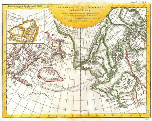
Carte Generale des Decouvertes de l'Amiral de Fonte et Autres Navigateurs Espagnols, Anglois et Russes pour la Recherche du Passage a la Mer du Sud.
1772 (undated) 11.5 x 15 in (29.21 x 38.1 cm)
1772 (undated) 11.5 x 15 in (29.21 x 38.1 cm)
Description
One of the most splendid combinations of hard fact and speculative fantasy to appear in the history of cartography. This map, prepared by Joseph-Nicholas de L'Isle 1762 and republished by Vaugondy in 1772, covers parts of Siberia and northeastern Asia as well as the northwestern parts of the American continent, including the Hudson Bay, and the legendary Northwest Passage. Traces the routes of several important explorers, most notably Tchirikow, Frondat, Bering and De Fonte.
The origins of the wonderful map can be traced to a 1706 English publication entitled 'Memoirs of the Curious.' This short-lived magazine published a previously unpublished account by a Spanish Admiral named Bartholomew de Fonte. De Fonte is said to have sailed up the Pacific coast of North America in 1640. On this voyage he apparently discovered a series of gigantic lakes, seas, and rivers heading eastward from the Pacific towards Hudson Bay. The De Fonte story relates how, on one of these great inland lakes, he met with a westward bound ship from Boston that must to have come through the Northwest Passage. Today, based upon inaccuracies and falsities, we know the entire De Fonte article to have been a fabrication, however, it set 18th century afire with speculation that a Northwest Passage must indeed exist.
When Joseph-Nicholas de L'Isle, younger brother of the better known Guilleme de L'Isle, returned from his tenure at Russian Tzar Peter the Great's 'Academy of Sciences' he decided to publish a compilation of secret cartographic data obtained from previously unknown Russian expeditions to Kamtschaka and the coast of Siberia. These seminal explorations included the discoveries of Tchirikow, Frondat, Bering, among others. He produced a ground breaking and largely accurate mapping of the peninsula of Kamchatka and the coast of northeast Asia. However, across the Pacific, the contrast with reality could not be more extreme.
De L'Isle based the fantastical North American portion of this map entirely on the supposed journeys of De Fonte. This map traces the course of De Fonte from Cape Medocino northward, past the mouth of the mythical 'Mer De L'Ouest' discovered by Juan de Fuca in 1692, around an unknown archipelago to access a series of lakes and rivers heading eastward to communicate with the Hudson Bay. It was on one of these great lakes, possibly the Lac Belle or the large Lac de Fonte, where De Fonte claims to have encountered a westward bound vessel heading from Boston. Heading north form this same archipelago, De L'Isle also describes De Fonte's Lac Valasco and Lake Bernarda, which run eastward towards Baffin Bay only to be blocked at their extreme eastern terminus. Dominating the northern part of the map is a great Arctic continent which blocks any further potential for a northwest passage to the north.
The upper left quadrant of this map features an alternative take on De Fonte's Strait of Anian. Anian was first mentioned in the journals of Marco Polo and was first noted on maps by Bolognini Zaltieri in 1561. Later the term was popularized in a John Donne poem, 'Anyan if I go west by the North-West passage.' In the 18th century, it was interpreted as the Bering Strait by cartographers, successfully transitioning it from the realms of fiction to cartography. Anian presupposed the existence of a Northwest Passage and, as such, was entirely mythical, though the lands that are now Alaska long bore that name.
This entire map is in sharp contrast to Jefferys' map of the same region. In an alternative to the De L'Isle map, Jefferys imagined a slightly more accurate picture of the extreme northeast with a series of large rivers running eastward towards Hudson Bay. These two disparate cartographic interpretations of the De Fonte story inspired considerable debate among European intellectual circles until the matter was finally put to rest by the expeditions of James Cook. Nonetheless, this is altogether fascinating map of the Northwest Passage and the American west and a must for any serious collection dedicated to this region.
This map is part of the 10 map series prepared by Vaugondy for the Supplement to Diderot's Encyclopédie, of which this is plate 7. This seminal map series, exploring the mapping of North American and specifically the Northwest Passage was one of the first studies in comparative cartography.
CartographerS
Robert de Vaugondy (fl. c. 1716 - 1786) was French may publishing from run by brothers Gilles (1688 - 1766) and Didier (c. 1723 - 1786) Robert de Vaugondy. They were map publishers, engravers, and cartographers active in Paris during the mid-18th century. The father and son team were the inheritors to the important Nicolas Sanson (1600 - 1667) cartographic firm whose stock supplied much of their initial material. Graduating from Sanson's maps, Gilles, and more particularly Didier, began to produce their own substantial corpus. The Vaugondys were well-respected for the detail and accuracy of their maps, for which they capitalized on the resources of 18th-century Paris to compile the most accurate and fantasy-free maps possible. The Vaugondys compiled each map based on their own geographic knowledge, scholarly research, journals of contemporary explorers and missionaries, and direct astronomical observation. Moreover, unlike many cartographers of this period, they took pains to reference their sources. Nevertheless, even in 18th-century Paris, geographical knowledge was limited - especially regarding those unexplored portions of the world, including the poles, the Pacific Northwest of America, and the interiors of Africa, Australia, and South America. In these areas, the Vaugondys, like their rivals De L'Isle and Buache, must be considered speculative or positivist geographers. Speculative geography was a genre of mapmaking that evolved in Europe, particularly Paris, in the middle to late 18th century. Cartographers in this genre would fill in unknown lands with theories based on their knowledge of cartography, personal geographical theories, and often dubious primary source material gathered by explorers. This approach, which attempted to use the known to validate the unknown, naturally engendered rivalries. Vaugondy's feuds with other cartographers, most specifically Phillipe Buache, resulted in numerous conflicting papers presented before the Academie des Sciences, of which both were members. The era of speculative cartography effectively ended with the late 18th-century explorations of Captain Cook, Jean Francois de Galaup de La Perouse, and George Vancouver. After Didier died, his maps were acquired by Jean-Baptiste Fortin, who in 1787 sold them to Charles-François Delamarche (1740 - 1817). While Delamarche prospered from the Vaugondy maps, he defrauded Vaugondy's window Marie Louise Rosalie Dangy of her rightful inheritance and may even have killed her. More by this mapmaker...
Denis Diderot (October 5, 1713 - July 31, 1784) was a French Enlightenment era philosopher, publisher and writer. Diderot was born in the city of Langres, France and educated at the Lycée Louis le Grand where, in 1732, he earned a master of arts degree in philosophy. Diderot briefly considered careers in the clergy and in law, but in the end chose the more fiscally challenge course of a writer. Though well respected in philosophical circles Diderot was unable to obtain any of the government commissions that commonly supported his set and consequently spent much of his life in deep poverty. He is best known for his role in editing and producing the Encyclopédie . The Encyclopédie was one of the most revolutionary and impressive works of its time. Initially commissioned as a translation of Ephraim Chambers' Cyclopaedia, or Universal Dictionary of Arts and Sciences, Diderot instead turned into a much larger and entirely new work of monumental depth and scope. Diderot's Encyclopédie was intended to lay bare before the common man the intellectual mysteries of science, art and philosophy. This revolutionary mission was strongly opposed by the powers of the time who considered a learned middle class it a threat to their authority. In the course of the Encyclopédie production Diderot was imprisoned twice and the work itself was officially banned. Nonetheless, publication continued in response to a demand exceeding 4000 subscribers. The Encyclopédie was finally published in 1772 in 27 volumes. Following the publication of the Encyclopédie Diderot grew in fame but not in wealth. When the time came to dower his only surviving daughter, Angelique, Diderot could find no recourse save to sell his treasured library. In a move of largess, Catherine the II Russia sent an emissary to purchased the entire library on the condition that Diderot retain it in his possession and act as her "librarian" until she required it. When Diderot died of gastro-intestinal problems 1784, his heirs promptly sent his vast library to Catherine II who had it deposited at the Russian National Library, where it resides to this day. Learn More...
The De L'Isle family (fl. c. 1700 - c. 1760) (also written Delisle) were, in composite, a mapmaking tour de force who redefined early 18th century European cartography. Claude De L'Isle (1644 -1720), the family patriarch, was Paris based a historian and geographer under Nicholas Sanson. De L'Isle and his sons were proponents of the school of "positive geography" and were definitive figures, defining the heights of the Golden Age of French Cartography. Of his twelve sons, four, Guillaume (1675 - 1726), Simon Claude (1675 - 1726), Joseph Nicholas (1688 - 1768) and Louis (1720 - 1745), made a significant contributions to cartography. Without a doubt Guillaume was the most remarkable member of the family. It is said that Guillaume's skill as a cartographer was so prodigious that he drew his first map at just nine years of age. He was tutored by J. D. Cassini in astronomy, science, mathematics and cartography. By applying these diverse disciplines to the vast stores of information provided by 18th century navigators, Guillaume created the technique that came to be known as "scientific cartography", essentially an extension of Sanson's "positive geography". This revolutionary approach transformed the field of cartography and created a more accurate picture of the world. Among Guillaume's many firsts are the first naming of Texas, the first correct map of the Mississippi, the final rejection of the insular California fallacy, and the first identification of the correct longitudes of America. Stylistically De L'Isle also initiated important changes to the medium, eschewing the flamboyant Dutch style of the previous century in favor of a highly detailed yet still decorative approach that yielded map both beautiful and informative. Guillaume was elected to the French Academie Royale des Sciences at 27. Later, in 1718, he was also appointed "Premier Geographe du Roi", an office created especially for him. De L'Isle personally financed the publication of most of his maps, hoping to make heavy royalties on their sales. Unfortunately he met an untimely death in 1728, leaving considerable debt and an impoverished child and widow. De L'Isle's publishing firm was taken over by his assistant, Phillipe Buache who became, posthumously, his son in law. The other De L'Isle brothers, Joseph Nicholas and Louis De L'Isle, were employed in the Service of Peter the Great of Russia as astronomers and surveyors. They are responsible for cataloguing and compiling the data obtained from Russian expeditions in the Pacific and along the northwest coast of America, including the seminal explorations of Vitus Bering and Aleksei Chirikov. The De L'Isles, like their rivals the Vaugondys , must be considered speculative geographers. Speculative geography was a genre of mapmaking that evolved in Europe, particularly Paris, in the middle to late 18th century. Cartographers in this genre would fill in unknown areas on their maps with speculations based upon their vast knowledge of cartography, personal geographical theories, and often dubious primary source material gathered by explorers and navigators. This approach, which attempted to use the known to validate the unknown, naturally engendered many rivalries. The era of speculatively cartography effectively ended with the late 18th century explorations of Captain Cook, Jean Francois de Galaup de La Perouse, and George Vancouver. Learn More...
Source
Supplement to Diderot, D., Encyclopédie, ou dictionnaire raisonné des sciences, des arts et des métiers; or Robert de Vaugondy, G., Recueil de 10 Cartes Traitant Particulierement de L'Amerique du Nord, (Paris) 1779.
Condition
Very good condition. Original centerfold. Wide clean margins. Original platemark visible. Blank on verso.
References
Pedley, Mary Sponberg. Bel et Utile: The Work of the Robert de Vaugondy Family of Mapmakers. 454. Wagner, Henry R., The Cartography of the Northwest Coast of America to the Year 1800,, 637-7. Kershaw, Kenneth A., Early Printed Maps of Canada, 1232. Phillips, P.L. (Atlases) 1195.7.