
1909 Stanford Case Map of Canada



This item has been sold.
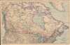
Stanford's General Map of the Dominion of Canada and Newfoundland.
Before nationalization.
- Digital Map Information
- Suitable for large format printing
- Full resolution TIFF file
- ICC color profile embedded
- Delivered instantly via download link
Before nationalization.
This is a 1909 Edward Stanford case map of Canada. Red overprinting highlights railways across Canada, including the Grand Trunk Railway, the Grand Trunk Pacific Railway, and the Canadian Northern Railway. Published during an era of massive railroad construction, solid red lines illustrate rail lines already in operation, while dashed lines promote lines under construction and projected lines, and only some of the projected lines were actually built. Canadian rail lines operated within the United States, even owning their own track in the U.S. The boom in railroad construction eventually fell apart, with several of these railways becoming bankrupt and then being nationalized by the Canadian government into the Canadian National Railways between 1918 and 1923.Publication History and Census
This map was created and published by Edward Stanford in 1909. Editions of this map were published as early as 1898 through at least the 1920s. The present example is the only known cataloged example of the 1909 edition.Cartographer
Edward Stanford (May 27, 1827 - November 3, 1904) was one of the most prolific map publishing firms of the late 19th century. The company began as a partnership in 1848 between the 21 year old Edward Stanford and the established map dealer Trelawney Saunders. By 1853 the partnership had dissolved and Edward Stanford took full control of the business. A subsequent series of expansions and exciting new map issues finally led to the production of Stanford's masterwork, "Stanford's Library Map of London". This map is still available and remains somewhat accurate. At the time of publishing it was hailed by the Royal Geographical Society as "the most perfect map of London that has ever been issued". In 1882 Edward Stanford Sr. passed the firm on to his son, Edward Stanford Jr. who continued in his father's proud tradition. Today the Stanford firm still publishes maps and remains one of the most important and prolific cartographic publishers in the world. Further Details...
Condition
Very good. Dissected and mounted on linen in forty (40) panels.