
1944 Dufrenoy Enormous Pictorial Map of the World, French Empire

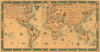
L'Empire Colonial Francais, 1506 - 1940.
Celebrating the Empire from Occupied France.
- Digital Map Information
- Suitable for large format printing
- Full resolution TIFF file
- ICC color profile embedded
- Delivered instantly via download link
Celebrating the Empire from Occupied France.
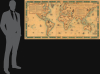
This is a highly scarce, visually stunning, and very large-format (38.25 x 73.25 in.) wall map of the world highlighting the French colonial empire, prepared by the cartographic firm Girard et Barrère. Curiously, it was produced in March 1944, when France itself was under German occupation and the empire was divided against itself among loyalists of Vichy and Free France.A Closer Look
This colorful pictorial map of the world presents both historical and contemporary borders, emphasizing French colonies, ranging from New France in North America to groups of African colonies (Afrique-Occidentale française and Afrique-Équatoriale française) to Indochine and French colonies in the South Pacific. Islands and smaller colonies have their names underlined with either red (France) or yellow (Britain). Algeria, of course, is notable as its northern portion had been organized into départements of metropolitan France (other colonies such as Réunion and Guyane would be after World War II).Illustrations throughout depict vignettes from French colonial history, including ships at sea, native inhabitants, local landmarks, and wildlife. The rhumb lines and sea creatures that appear at sea are reminiscent of early modern maps which guided the earliest French colonial ventures. Two text boxes provide timelines of the 'first' (up to and including Napoleon) and 'second' (post-Napoleonic) French colonial empires, respectively. The decorative border includes great names from French colonial history, including Cartier, Champlain, and Cadillac.
This map is especially notable for having been produced in Paris in March 1944, not long before the D-Day landings that would eventually lead to the liberation of Paris in August. On the one hand, the map would appear to be politically safe as Vichy extolled the empire and it makes no overt criticism of or even reference to the German occupation or Vichy regime. On the other, the subject of the empire was a touchy one (see below) and the dates used to bookend the map's title suggest that the empire was a thing of the past, dying with the Fall of France in 1940 (any overt criticism would of course be subject to censorship or worse). Whether intended as a subtle criticism of Vichy or not, the makers of the map were in a sense proven correct as France struggled to maintain control over the empire in the Postwar period in the wake of its national humiliation at the hands of Hitler.
Interestingly, the verso appears to be a collage of Ottoman maps, which much have been produced in the very late 1910s or early 1920s as the borders of Europe reflect the Interwar period but the maps retain the Ottoman Turkish script instead of using the Latin alphabet of modern Turkish. This may have been the result of wartime shortages, with Girard et Barrère reappropriating whatever paper was on hand.
An Empire Divided
During World War II, the French colonial empire became a crucial battleground for legitimacy and power after the fall of metropolitan France in 1940. Following the armistice with Germany, most of the empire initially aligned with the collaborationist regime of Marshal Philippe Pétain based in Vichy, while General Charles de Gaulle sought to rally colonies to his movement, which became known as the Free French. This internal split turned the empire into both a strategic asset and a symbol of political continuity, as control over overseas territories allowed de Gaulle to claim that France was still fighting the war despite occupation at home.The struggle between Vichy loyalists and de Gaulle's supporters played out unevenly across the empire. French Equatorial Africa was among the first to break with Vichy in 1940, providing the territorial base for the Free French, while other areas remained under Vichy control until military intervention forced a change of allegiance (in the case of Indochine, this came at the hands of Imperial Japan, which deposed the French in March 1945). The most dramatic confrontations came in the Levant and in North Africa; in 1941, Allied and Free French forces fought Vichy troops in Syria and Lebanon, and in 1942 the Allied landings in North Africa (Operation Torch) sparked a tense showdown among Vichy officials, local commanders, and Gaullists before the region shifted into the Allied camp. As the war progressed, internal rivalries within the anti-Vichy camp itself, including tensions between de Gaulle and rival figures, reflected ongoing debates over the future political order of France and its empire.
By the end of the war, the experience of division and warfare within the colonies had fundamentally altered the French imperial system. De Gaulle and the provisional government tried to reassert control after France itself was liberated, but wartime mobilization of colonial troops and the weakening of imperial authority encouraged new nationalist movements, accelerating the long-term decline of the French colonial empire itself.
Publication History and Census
This map was prepared by the Parisian cartographic firm Girard et Barrère (successors to Andriveau-Goujon) and printed by Dufrenoy in March 1944. A later (1951) edition is cataloged at the Bibliothèque nationale de France, but we have been unable to locate any other examples of this 1944 edition in institutional collections or on the market.Cartographers
Eugène Dufrenoy (January 21, 1834 - 190x), aka Dufrenois, was a French printer, lithographer, and engraver active in Paris during the second half of the 19th and the early 20th centuries. Dufrénoy born in Bourg-la-Reine, in what is today the southern suburbs of Paris. He was based, for at least part of his career, at 34 Rue du Four, Paris. In 1881 Dufrénoy acquired a large space at 49 Rue du Montparnasse. This space still operates as a printshop with Dufrénoy's old presses as IDEM Paris. ˜ Further Details...
Eugène Andriveau-Goujon (1832 - 1897) was a map publisher and cartographer active in 19th century Paris. The firm was created in 1825 when Eugène Andriveau married the daughter of map publisher Jean Goujon - thus creating Andriveau-Goujon. Maps by Andriveau-Goujon are often confusing to identify as they can be alternately singed J. Goujon, J. Andriveau, J. Andriveau-Goujon, E. Andriveau-Goujon, or simply Andriveau-Goujon. This refers to the multiple generations of the Andriveau-Goujon dynasty and the tendency to republish older material without updating the imprint. The earliest maps to have the Andriveau-Goujon imprint were released by Jean Andriveau-Goujon. He passed the business to his son Gilbert-Gabriel Andriveau-Goujon, who in 1858 passed to his son, Eugène Andriveau-Goujon, under whose management the firm was most prolific. Andriveau-Goujon published numerous fine pocket maps and atlases throughout the 19th century and often worked with other prominent French cartographers such as Adrien-Hubert Brué (1786 - 1832) and Victor Levasseur (1800 - 1870). The firm's stock was acquired by M. Barrère in 1892, who operated it until c. 1930, when it passed on to P.H. Barrère (presumably his son). In 1933, the firm was merged to become Girard et Barrère and in the post-World War II period operated as Girard, Barrère et Thomas until it was purchased by Cartes Taride in 1974. Further Details...
Condition
Good. Varnished. Some toning. Laid on linen, verso is transparent with ottoman maps behind. Rare.
References
OCLC 494529827 (1951 ed.).