This item has been sold, but you can get on the Waitlist to be notified if another example becomes available, or purchase a digital scan.
1869 Murray Map of Corfu and Epirus, Greece
EpirusCorfu-murray-1869$100.00

Title
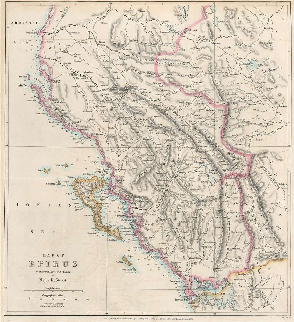
Map of Epirus to accompany the Paper by Major R. Stuart.
1869 (dated) 13.25 x 12.25 in (33.655 x 31.115 cm) 1 : 745920
1869 (dated) 13.25 x 12.25 in (33.655 x 31.115 cm) 1 : 745920
Description
An important geographical region in antiquity and a popular tourist destination today, this is an 1869 John Murray map of Corfu and Epirus, Greece. Corfu appears in the Ionian Sea just off the coast of Epirus. Cities and towns throughout, including Corfu, the largest city on the island of Corfu, and Ioannina (labeled here as Yanina), the regional capital.
Corfu - An Ancient Wonder and Modern Paradise
Corfu has been a magnet for the wealthy for centuries. The island played a critical role in many Ancient Greek myths and became a focal point of the Peloponnesian War (431 - 405 B.C.E.). Then, it became part of the Roman and Byzantine Empires before falling under the sway of Venice. Under Venetian rule Corfu served as a bastion against Ottoman incursion into the Adriatic. The island was ceded to the French in 1797 and became a British protectorate after the Napoleonic Wars (1803 - 1815). Even before the 20th century, the island was a popular destination for Europe's royals and elites. In the 20th century tourism became Corfu's primary industry. British holiday companies began developing both the north and south coasts. After World War II, package holiday resorts began opening and the island became a much less exclusive destination. Today the island welcomes thousands annually.The Battle of Actium
Perhaps the most important historic event on Corfu was the Battle of Actium ()September 2, 31 BCE), fought near Preversa and Preversa Strait, both of which are labeled here. Fought between Octavian (who would become Emperor Augustus) and the armies of Mark Antony and Queen Cleopatra, the Battle of Actium saw the destruction of Antony's and Cleopatra's fleet securing Octavian, or Augustus's, place as the 'first citizen' of Rome.Publication History and Census
This map was created by John Murray and engraved by Edward Weller for publication in Volume 39 of The Journal of the Royal Geographical Society of London in 1869. Although not in the OCLC, a separate example is recorded in the Princeton University Libraries.CartographerS
John Murray I (1737 - 1793) founded the British publishing firm John Murray (1768 - present) in London. Born in Edinburgh, Murray served as an officer in the Royal Marines and built a list of authors that included Isaac D’Israeli and published the English Review. Murray the elder also was one of the founding sponsors of the London evening newspaper The Star in 1788. John Murray II (November 27 1778 - June 27, 1843) continued the family publishing business and developed it into one of the most important and influential publishing houses in Britain. The list of authors published by the firm grew to include Jane Austen, Sir Walter Scott, Washington Irving, George Crabbe, and Lord Byron under his tenure. Murray II also moved the business to 50 Albermarle Street in Mayfair, which became famous for Murray’s tradition of ‘four o’clock friends’, which was afternoon tea with his writers. John Murray III (1808 - 1892) continued to grow the business, and the firm published the first English translation of Goethe’s Theory of Colours, David Livingstone’s Missionary Travels and Charles Darwin’s Origin of Species during his tenure. Murray also published Herman Melville’s first two books. The firm began publishing Murray Handbooks in 1836, an ancestor of all modern travel guides. Sir John Murray IV (1851 - 1928) was publisher to Queen Victoria. Three successive Murray’s after Murray IV led the business until it was purchased by Hodder Headline in 2002, which was acquired by the French conglomerate Lagardère Group in 2004. Today, Murray is an imprint of Lagardère under the imprint Hachette UK. More by this mapmaker...
Edward Weller (July 1, 1819 - 1884) was a cartographer and engraver based in London. Weller was a nephew of another well-known map publisher Sidney Hall (1788 - 1831), who gave him 50 Pounds to pay his apprenticeship fees. He engraved for many prominent mapmakers and was active enough in the community to be recommended for membership to the Royal Geographical Society in 1851 on the recommendation of John Arrowsmith, among others. He eventually inherited the Sidney Hall map business which led him to follow Arrowsmith as the unofficial geographer to the Royal Geographical Society. Weller was among the first map printers in London to embrace lithography. His best known work appears in Cassell's Weekly Dispatch Atlas, published in monthly segments for subscribers of the 'Weekly Dispatch' newspaper. This collection of maps eventually grew to include much of the known world. Published in various editions from 1855 through the early 1880s. Weller died in May of 1884, leaving behind a successful business and an unhappy widow. His son, Francis Sidney Weller (1849 - 1910), followed in his father's footsteps and continued the family map business. The atlas Mackenzie's Comprehensive Gazetteer of England and Wales was published in 1894 and bore F. S. Weller's signature on the maps. Learn More...
Royal Geographical Society (fl. 1830 - present) is a British Society established in 1830 to promote geographical science and exploration. Originally titled the "Geographical Society of London", the RGS received its royal charter from Queen Victoria in 1859 shortly after absorbing several similar but more regional societies including the African Association, the Raleigh Club and the Palestine Association. The RGS sponsored many of the most important and exciting voyages of exploration ever undertaken, including the exploration of Charles Darwin, David Livingstone, Robert Falcon Scott, Richard F. Burton, John Speke, George Hayward, H. M Stanley, Ernest Shackleton and Sir Edmond Hillary. Today, the RGS remains a leading global sponsor of geographical and scientific studies. The Society is based in Lowther Lodge, South Kensington, London. Learn More...
Source
Stuart, R., 'On the Physical Geography and Natural Resources of Epirus', The Journal of the Royal Geographical Society of London, Vol. 39 (London: Royal Geographical Society) 1869.
Condition
Very good. Exhibits light wear along original fold lines. Closed tear extending vertically 1.25 inches along right border professionally repaired on verso. Exhibits close margins, as issued. Blank on verso.
References
Princeton University G6812.E6C1 1869 .R6.