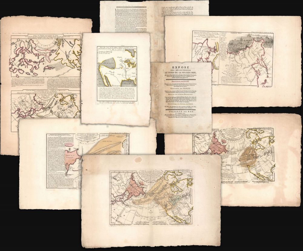
1753 Buache / De l'Isle Map Set Revealing a Compelling Northwest Passage
Expose-buachedelisle-1753$16,000.00


Title
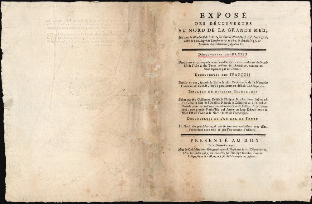
Exposé des Découvertes au Nord de la Grande Mer...
1753 (dated) 10 x 14 in (25.4 x 35.56 cm)
1753 (dated) 10 x 14 in (25.4 x 35.56 cm)
Description
This is an extremely rare example of Philippe Buache's 1753 Exposé des Découvertes au Nord de la Grande Mer, the essential maps published to support the astonishing geographical theories of Philippe Buache and Joseph Nicolas De l'Isle, presented in August 1752 to the Paris Academie des Sciences. It was then the most complete cartographical defense of Nicolas De l'Isle's 'exposé' of Russian cartographic advances, along with Buache's synthesis of several mappings of the Pacific Northwest, revealing compelling (if ultimately false) evidence of a viable Northwest Passage. These maps were later included in the 1753-1755 Considérations Géographiques, 'the magnum opus of the Delisle-Buache theory of the layout of lands in the North Pacific space,' (Lada-Mocarski, 1969) appearing there in their second states. These six sheets are all first state examples, indicating that the Exposé enjoyed an earlier publication, spurred perhaps by the novelty of Buache and De l'Isle's arguments and the urgency with which the two geographers wished to assuage and rebut critics of their presentation to the Academie.
The De Fonte cartography appears on four of the six sheets in this set, and in two specific forms, shown in comparison with one another: One based on Buache and De l'Isle's interpretation, and the other derived from 'The English Chart given by the Clerk of the vessel 'California.' The latter represents a direct connection with Dobbs' campaign against the Hudson's Bay Company. The California was one of two ships commissioned in 1746 by Arthur Dobbs to follow up the contentious 1741 Middleton Expedition. This second expedition of 1746-47 confirmed Middleton's conclusion that Wager Bay, Rankin Inlet, and the newly discovered Chesterfield Inlet, were not passages to the Pacific Ocean. (Although the report of the expedition did include a map, it does not resemble the cartography shown here.) The 'Clerk' in question, Theodore Swaine Drage, does not appear to have accepted the results of the expedition, and published further in support of a Northwest Passage his expeditions failed to discover.
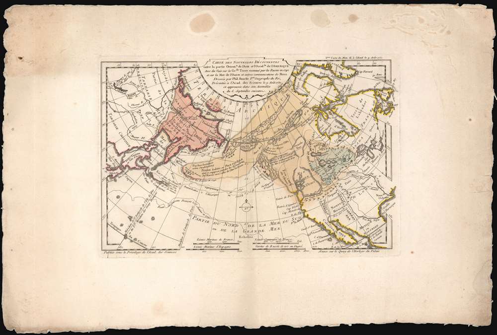
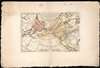
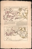
Map 1: Carte des Nouvelles Decouvertes entre la partie Orient.le de l’Asie et l’Occid.le de l’Amerique… This is De l'Isle and Buache's centerpiece map, roughly a re-statement of their 1752 Carte Des Nouvelles Decouvertes au Nord de la Mer de Sud and represents a summary of their theories. It combines De l'Isle's purloined Russian cartography with Buache’s Sea of the West, set in context with the supposed explorations of De Fuca and De Fonte.
The Asian side of the map reveals the advances of mid-18th century Russian cartographers. A stippled 'coastline' shows the northeast Asian coast as it was supposed in 1724 by Guillaume De l'Isle. The new, Russian-sourced cartography - emphasized with red wash color - reaches far to the east of the elder De l'Isle's limits. In outline and detail, it corresponds strongly with Kirilov's mapping of Asia (unsurprising, as Joseph De l'Isle participated in Kirilov's work). Other revelations of Russian knowledge include Bering's voyage of 1728 - 1731 and Chirikov's trans-Pacific voyage of 1741. Buache and De l'Isle include Strahlenberg's Puchochotskes (Alaska), supposing it to be a peninsula connecting the lands touched by Chirikov with the supposed discoveries of De Fonte. The resulting peninsula is reminiscent of the Muller Peninsula, though lacking Muller's sightings of the Aleutian archipelago. The map stops just short of showing an explicit northwest passage, but it is easy to conclude that one or more connections might exist between maritime Canada and the various passages proposed in the De Fonte letter. Nestled between the Mer de l'Ouest and the Russian archipelago can be found the legendary Chinese colony of Fusang. 8.25 x 12.25 inches. Some marginal staining and wear to edges; generous margins. Original wash and outline color.
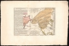
Map 2: Carte des Decouv.tes de l’Am.al de Fonte selon la Carte Angloise donnée par l'Ecrivain du Vaisseau la Californie dans son Voyage à la Baye d'Hudson. The second map of the Exposé focuses more specifically on the invented discoveries of De Fonte, but couched in a framework connecting it with the factual mapping of the North Pacific, as well as contemporaneous efforts to reveal a Northwest Passage. The Russian part of the map, and the Americas not pertaining to the Northwest are highly comparable to the previous map, but the central portion shows a different interpretation of the De Fonte cartography, here sourced from Theodore Swaine Drage. As with the previous map, there is not quite an explicit Northwest Passage, but the easternmost reachs of De Fonte's passages come very close to Hudson's Bay, with a note indicating the position where De Fonte was said to have met a ship sailing out of Boston, skippered by one 'Captain Schapely.'
The Pacific Ocean includes, in dotted lines, the coastlines of the American North Pacific as shown on 'an ancient Dutch Sea Chart,' as well as specific portions of coastline drawn from the seventeenth-century charts of Robert Dudley. 8.25 x 12.25 inches; Some marginal staining and wear to edges; generous margins. Original wash and outline color.
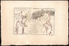
Map 3: Carte du Geometrique des Decouvertes de l’Amiral de Fonte et de son Capitaine Bernarda Comparée avec e Systeme de la Carte Angloise. This third map of the Exposé narrows in on the Pacific Northwest, comparing specifically the geography derived from De Fonte with that provided in the Carte Angloise, that is to say the one provided by Theodore Swaine Drage. It is accompanied by a text synopsizing the imaginary voyages of De Fonte and Bernarda. Although both the Buache / De l'Isle and the Dobbs / Drage maps are interpretations of De Fonte, they differ sharply in position and size. The lakes 'Valasco' and 'De Fonte' appearing in the English cartography are much closer to each other and are shown at the latitudes of Hudson's Bay, suggesting a connection. Buache and De l'Isle, who would have known the results of both of the Dobbs expeditions to Hudson's Bay, have their De Fonte cartography reaching far to the north, suggesting a connection with Baffin's Bay or perhaps some as-yet-undiscovered point between Baffin's and Hudson's Bay. 8.25 x 12.5 inches; Some wear to edges; generous margins. Original wash and outline color.
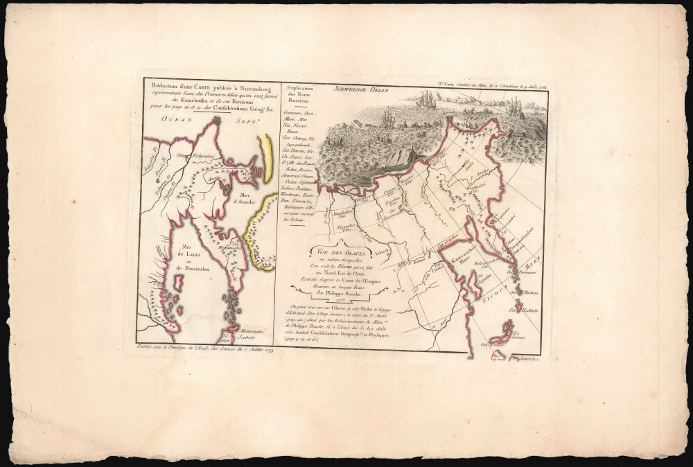
Map 4 Reduction d’une Carte publee a Nuremberg representant l’une des Premieres Idees qu’on s’est forme du Kamchatka et de ses Environs... These two maps, printed side by side are intended to show the rapid advances in Russian cartography of the eastern extremes of their Empire. The map to the left - the 'Reduction of a Map Published in Nuremberg' - is the 1725 Johann Baptiste Homann map of Kamchatka, which was certainly derived from an unpublished preliminary concept version of Philipp Johann Strahlenberg's map of Russia in Tatary sent to the Moscow-based Swedish diplomat Josias Cederhielm (1673 - 1729) in 1719 (sent by Strahlenberg out of Russia when his work was seized by Russian officials and destroyed in 1719.) The map on the right is Kirilov-derived cartography spirited away from the Russian Academy of Sciences by De l'Isle when he returned to Paris. 8.25x 12. 25 inches; Some wear to edges; generous margins. Original wash and outline color.
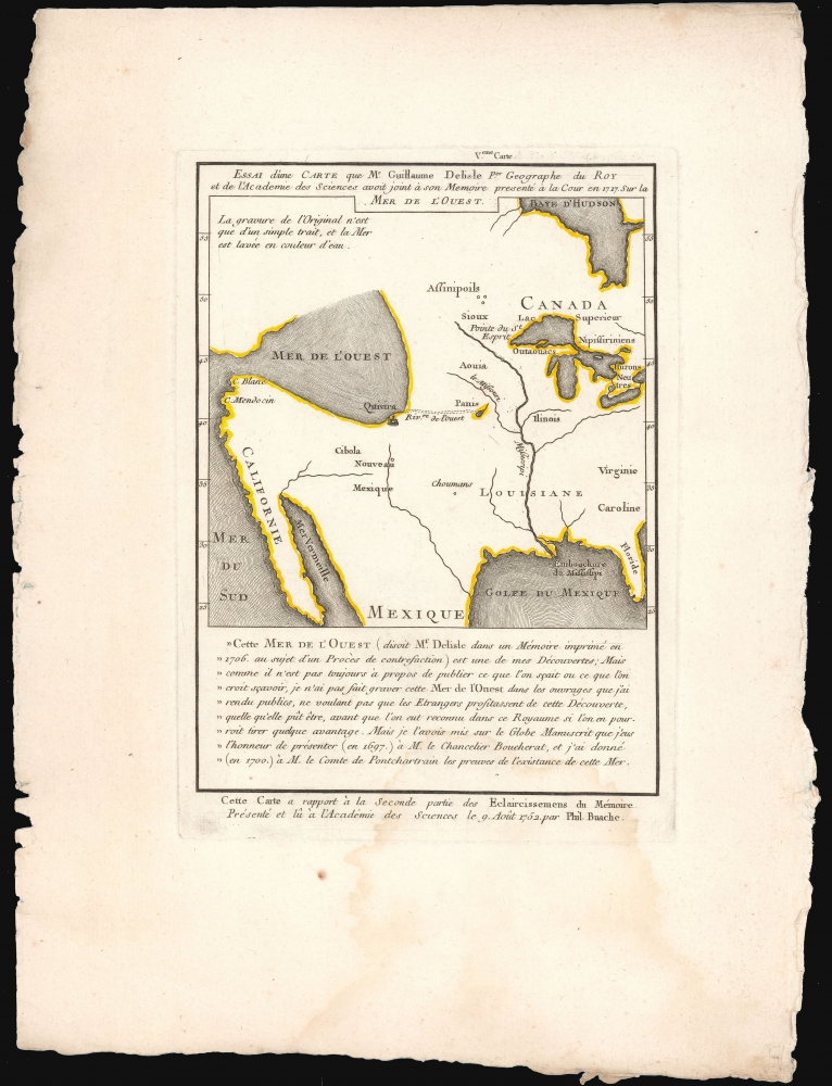
Map 5 Essai d’une Carte que M. Guillaume Delisle P.er Geographe du Roy et de l’Academie des Sciences avoit joint a son Memoire presente a la Cour en 1717 Sur la Mer de l’Ouest. This sheet focuses on the posthumous contributions of Guillaume De l'Isle to the Buache / Nicholas De l'Isle cartography. It consists of a map of North America, spanning from the Great Lakes to the Pacific Coast, attributed to a manuscript found amongst the elder De l'Isle's letters by his younger brother. The map shows a pronounced Mer de l'Ouest with its Pacific entrance at C. Blanc, and with the legendary city of Quivira on its southern shore (as is presented on the first map of this set). The map includes a note that 'The inscription of the original is but a single stroke, and the sea is washed in a color of water.' This suggests that the original was not quite so emphatic in its presentation of the Sea as it is here. The map is accompanied with a text attributed to the elder De l'Isle, supposedly appearing in the context of his court proceedings against plagiarists:
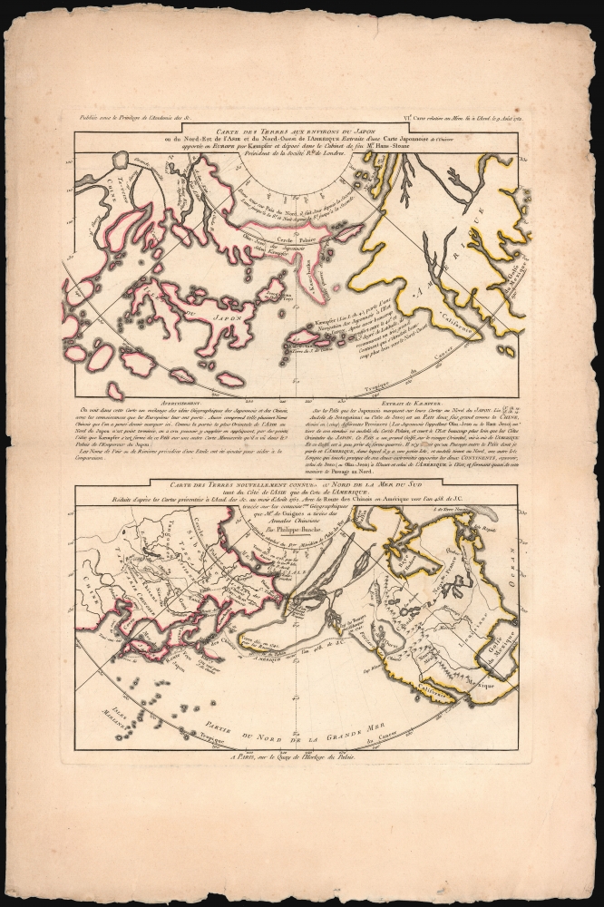
Map 5Carte Des Terres aux Environs du Japon… / Cart des Terres Nouvellement Connues au Nord De la Mer du Sud… The two maps combined on this sheet add the perspectives, derived from Engelbert Kaempfer (1651 - 1716), of Japanese cartography of the seventeenth century and from Joseph de Guignes' (1721 - 1800) report of ancient Chinese records of trans-Pacific voyages to the colony of Fusang. The upper map is attributed to a Japanese world map brought by Kaempfer to the president of the Royal Society, Sir Hans Sloane. The lower map uses a simplified form of the Buache/De l'Isle map as a framework for showing the track of a 458 CE voyage from China to Fu Sang, as derived from Joseph de Guignes' 1761 'Le Fou-Sang des Chinois est-il l'Amérique?' 14.75 x 10.5 inches; Some wear to edges; generous margins. Original outline color.
Novel Cartography
Joseph Nicolas De l'Isle, the younger brother of Guillaume de L'Isle (1675 - 1726), contributed a wealth of new cartographic information to these maps. He spent the previous decades at the St. Petersburg in the Russian Academy of Sciences, where he had access to the suppressed maps and records of Kirilov and Bering. On returning to France, his main purpose in working with Buache was to publish these findings prior to the release of an official Russian map. De l'Isle's cartography on the 1752 map presented to the Academie was groundbreaking. The information revealed on the American side of the Pacific was no less novel, despite less than authoritative sources. Buache and Joseph Nicolas De l'Isle's combination of elder brother Guillaume De l'Isle's Sea of the West with the (probably imaginary) northwestern explorations of Juan de Fuca with the (certainly imaginary) explorations of Admiral De Fonte presented something suggestive of a viable Northwest Passage: thus keeping the maps current with English efforts to find the passage.The Sea of the West
At the core of the Exposé is the Sea of the West: a speculative massive body of water extending from the Pacific far into the then-little-known Northwest of North America. It first appeared on a printed map in 1700, but it was not until Buache and De l'Isle's 1752 Carte des Nouvelles Découvertes au Nord de la Mer du Sud and their presentation of that map to the Academie that it took definitive form. The idea first appeared in the manuscript notes of the illustrious Guillaume De L'Isle (1675 - 1726), Geographer to the King of France and the preeminent cartographer of his generation. Although some of these manuscripts still survive in the Bibliotheque National, De l'Isle never committed the idea of a Sea of the West to print. Jean-Baptiste Nolin (1657 - 1725) attempted to include the sea in some of his maps, but these were stolen from a 1699 manuscript globe made by De L'Isle. De l'Isle sued successfully to stop Nolin from using the Sea of the West cartography on the grounds of plagiarism, but also perhaps to protect his own reputation. His reluctance to include a Sea of the West on his published works suggests he doubted the theory - although the fifth sheet of this set includes text from Guillaume's letters in connection to the plagiarism lawsuits, during which his depiction of the Sea appeared, and wherein De L'Isle wrote that he refrained from publishing his Mer l'Ouest to prevent knowledge of it from disseminating to rival foreign powers. Despite the reasons for Guillaume De l'Isle's reluctance to publicize the Sea of the West, his credibility was such that Buache and the younger De l'Isle strategically attached his name to their invented map, to confer unassailable authority. The geographical innovation of Buache and the younger (Joseph Nicholas) De l'Isle is not only in bringing to light the fictional 'Sea' Guillaume wisely avoided printing, but in combining it with other cartographic canards to form an attractive and compelling whole.The Strait of De Fuca
Part of the inspiration for the Sea of the West - perhaps even its appearance on Guillaume De l'Isle's manuscript - lies in the sixteenth-century discoveries in the Pacific Northwest by Juan de Fuca. De Fuca (Ioannis Phokas; 1536 - 1602) - was a Greek pilot and explorer in the service of Philip II. His claims at having explored the Strait of Anián are depicted on several of these maps. The de Fuca tale was preserved in the account of Michael Lok, an Englishman attempting to convince Queen Elizabeth to bring De Fuca into her service in 1596. Via Lok, De Fuca reported that his second attempt at Anián was a success, revealing a strait at 48° North - now understood to have been the strait between Vancouver Island and the Olympic Peninsula, which bears his name. Much of De Fuca's tale strained credibility - after all, it was first revealed via the account of Michael Lok, whose motivations welcome skepticism. It appears likely that De Fuca had not made the relevant voyage at all, and that he or Lok spun the tale to extract money from the English government - although recent scholarship suggests that the Lok / De Fuca narrative lay in suppressed information from the 1579 voyage of Sir Francis Drake. As late as 1752, the exploration of the Pacific Northwest was insufficient to disprove Lok's report, and De Fuca's Strait suggested that a passage through the Pacific Coast existed that would lead to something that might connect to Hudson Bay, or rivers convenient to the Great Lakes. The Pacific entrance to the Sea of the West depicted in the Buache-De l'Isle maps closely conforms to the Strait of De Fuca.Admiral De Fonte, Arthur Dobbs and the Northwest Passage
A third major element to the Buache - De l'Isle cartography, one explored in four of the six maps here, is based on the supposed seventeenth century explorations of one Bartholomew de Fonte. Styled the Admiral of New Spain and Peru, and Prince of Chile, this remarkable person was reputed to have explored the northwest coast of America, and to have discovered a viable passage from the Pacific to the Atlantic Oceans. De Fonte first came to light in the April and June 1708 issues of The Monthly Miscellany or Memoirs for the Curious, and proved to be a complete fabrication, now attributed to the editor or owner of that magazine, James Petiver. Whatever the purpose of the fiction, no serious attention was paid to the De Fonte letter until the story was taken up by Irish politician and career-destroying gorgon Arthur Dobbs. Dobbs embraced the De Fonte cartography in a feverish campaign to break the Hudson’s Bay Company’s trade monopoly. Arguing that the Company deliberately hid evidence of a Northwest Passage in order to preserve their control of Northern trade, and proffered the De Fonte story as convincing evidence that such a passage existed. Dobbs in 1740 commissioned Captain Christopher Middleton to sail to Hudson's Bay and reveal passages westward to the Pacific. Middleton's news that no such passage existed was poorly received, and the vindictive Dobbs - aided by cowardly place-seekers on Middleton's crew - accused the Captain of being in the pay of the Hudson's Bay Company and either malingering or deliberately obscuring the existence of a passage at the end of what Middleton named Wager Bay, and what Dobbs and his minions called Wager Strait. Buache and De l'Isle's map diplomatically refers to the body of water as 'Eau de Wager'. Dobbs sent a further expedition to prove his case in 1746. The Dobbs Galley and California confirmed Middleton's findings that no Northwest Passage existed out of Hudson's Bay. Nevertheless, Dobbs' championship of De Fonte continued unabated, leading to its acceptance not only by Dobbs' supporters, but by Buache and De l'Isle. Even Benjamin Franklin wrote long defenses of De Fonte.The De Fonte cartography appears on four of the six sheets in this set, and in two specific forms, shown in comparison with one another: One based on Buache and De l'Isle's interpretation, and the other derived from 'The English Chart given by the Clerk of the vessel 'California.' The latter represents a direct connection with Dobbs' campaign against the Hudson's Bay Company. The California was one of two ships commissioned in 1746 by Arthur Dobbs to follow up the contentious 1741 Middleton Expedition. This second expedition of 1746-47 confirmed Middleton's conclusion that Wager Bay, Rankin Inlet, and the newly discovered Chesterfield Inlet, were not passages to the Pacific Ocean. (Although the report of the expedition did include a map, it does not resemble the cartography shown here.) The 'Clerk' in question, Theodore Swaine Drage, does not appear to have accepted the results of the expedition, and published further in support of a Northwest Passage his expeditions failed to discover.
Fou-sang
Buache and De l'Isle also include another cartographic cause celebré, the legendary Chinese colony of Fusang (扶桑). Here it appears on the coast between the Sea of the West and De Fonte's spurious archipelago, consistent with Fusang's usual placement near modern-day British Columbia. Fusang or Fousang is a region first documented by the 5th century Chinese Buddhist missionary Hui Shen. Hui Shen described a land some 20,000 Chinese Li (c. 8000 km) east of the China coast. Fousang was again described in considerable detail in the 635 CE Book of Liang (梁書) by Yao Silian (姚思廉; ??? - 637). There are also accounts of how Fusang was settled c. 220 BC by a Chinese Emperor of the Han Dynasty. In later days, Fusang was commonly used in Chinese poetry to designate Japan, despite the fact that earlier references keep it distinct. In any case, Hui Shen's description of Fusang with regard to distance and geography corresponds more with the coastlands of North America than with Japan. His descriptions include plants resembling corn and agave, which would have been alien to the Chinese. The French historian Joseph de Guignes and other cartographers of the era, including Zatta, Vaugondy, Desnos, and others, embraced the idea and it was included in many subsequent maps of the region.Contents of the Set
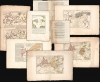
Title Sheet and Introduction: Exposé des Découvertes au Nord de la Grande Mer... Presenté au Roy Le 2. Septembre 1753. 1 sheet printed recto and verso, 3 pages introductory text. Old hand color underlining titles. Cracking and splitting at centerfold with old mends.Map 1: Carte des Nouvelles Decouvertes entre la partie Orient.le de l’Asie et l’Occid.le de l’Amerique… This is De l'Isle and Buache's centerpiece map, roughly a re-statement of their 1752 Carte Des Nouvelles Decouvertes au Nord de la Mer de Sud and represents a summary of their theories. It combines De l'Isle's purloined Russian cartography with Buache’s Sea of the West, set in context with the supposed explorations of De Fuca and De Fonte.
The Asian side of the map reveals the advances of mid-18th century Russian cartographers. A stippled 'coastline' shows the northeast Asian coast as it was supposed in 1724 by Guillaume De l'Isle. The new, Russian-sourced cartography - emphasized with red wash color - reaches far to the east of the elder De l'Isle's limits. In outline and detail, it corresponds strongly with Kirilov's mapping of Asia (unsurprising, as Joseph De l'Isle participated in Kirilov's work). Other revelations of Russian knowledge include Bering's voyage of 1728 - 1731 and Chirikov's trans-Pacific voyage of 1741. Buache and De l'Isle include Strahlenberg's Puchochotskes (Alaska), supposing it to be a peninsula connecting the lands touched by Chirikov with the supposed discoveries of De Fonte. The resulting peninsula is reminiscent of the Muller Peninsula, though lacking Muller's sightings of the Aleutian archipelago. The map stops just short of showing an explicit northwest passage, but it is easy to conclude that one or more connections might exist between maritime Canada and the various passages proposed in the De Fonte letter. Nestled between the Mer de l'Ouest and the Russian archipelago can be found the legendary Chinese colony of Fusang. 8.25 x 12.25 inches. Some marginal staining and wear to edges; generous margins. Original wash and outline color.
Map 2: Carte des Decouv.tes de l’Am.al de Fonte selon la Carte Angloise donnée par l'Ecrivain du Vaisseau la Californie dans son Voyage à la Baye d'Hudson. The second map of the Exposé focuses more specifically on the invented discoveries of De Fonte, but couched in a framework connecting it with the factual mapping of the North Pacific, as well as contemporaneous efforts to reveal a Northwest Passage. The Russian part of the map, and the Americas not pertaining to the Northwest are highly comparable to the previous map, but the central portion shows a different interpretation of the De Fonte cartography, here sourced from Theodore Swaine Drage. As with the previous map, there is not quite an explicit Northwest Passage, but the easternmost reachs of De Fonte's passages come very close to Hudson's Bay, with a note indicating the position where De Fonte was said to have met a ship sailing out of Boston, skippered by one 'Captain Schapely.'
The Pacific Ocean includes, in dotted lines, the coastlines of the American North Pacific as shown on 'an ancient Dutch Sea Chart,' as well as specific portions of coastline drawn from the seventeenth-century charts of Robert Dudley. 8.25 x 12.25 inches; Some marginal staining and wear to edges; generous margins. Original wash and outline color.
Map 3: Carte du Geometrique des Decouvertes de l’Amiral de Fonte et de son Capitaine Bernarda Comparée avec e Systeme de la Carte Angloise. This third map of the Exposé narrows in on the Pacific Northwest, comparing specifically the geography derived from De Fonte with that provided in the Carte Angloise, that is to say the one provided by Theodore Swaine Drage. It is accompanied by a text synopsizing the imaginary voyages of De Fonte and Bernarda. Although both the Buache / De l'Isle and the Dobbs / Drage maps are interpretations of De Fonte, they differ sharply in position and size. The lakes 'Valasco' and 'De Fonte' appearing in the English cartography are much closer to each other and are shown at the latitudes of Hudson's Bay, suggesting a connection. Buache and De l'Isle, who would have known the results of both of the Dobbs expeditions to Hudson's Bay, have their De Fonte cartography reaching far to the north, suggesting a connection with Baffin's Bay or perhaps some as-yet-undiscovered point between Baffin's and Hudson's Bay. 8.25 x 12.5 inches; Some wear to edges; generous margins. Original wash and outline color.
Map 4 Reduction d’une Carte publee a Nuremberg representant l’une des Premieres Idees qu’on s’est forme du Kamchatka et de ses Environs... These two maps, printed side by side are intended to show the rapid advances in Russian cartography of the eastern extremes of their Empire. The map to the left - the 'Reduction of a Map Published in Nuremberg' - is the 1725 Johann Baptiste Homann map of Kamchatka, which was certainly derived from an unpublished preliminary concept version of Philipp Johann Strahlenberg's map of Russia in Tatary sent to the Moscow-based Swedish diplomat Josias Cederhielm (1673 - 1729) in 1719 (sent by Strahlenberg out of Russia when his work was seized by Russian officials and destroyed in 1719.) The map on the right is Kirilov-derived cartography spirited away from the Russian Academy of Sciences by De l'Isle when he returned to Paris. 8.25x 12. 25 inches; Some wear to edges; generous margins. Original wash and outline color.
Map 5 Essai d’une Carte que M. Guillaume Delisle P.er Geographe du Roy et de l’Academie des Sciences avoit joint a son Memoire presente a la Cour en 1717 Sur la Mer de l’Ouest. This sheet focuses on the posthumous contributions of Guillaume De l'Isle to the Buache / Nicholas De l'Isle cartography. It consists of a map of North America, spanning from the Great Lakes to the Pacific Coast, attributed to a manuscript found amongst the elder De l'Isle's letters by his younger brother. The map shows a pronounced Mer de l'Ouest with its Pacific entrance at C. Blanc, and with the legendary city of Quivira on its southern shore (as is presented on the first map of this set). The map includes a note that 'The inscription of the original is but a single stroke, and the sea is washed in a color of water.' This suggests that the original was not quite so emphatic in its presentation of the Sea as it is here. The map is accompanied with a text attributed to the elder De l'Isle, supposedly appearing in the context of his court proceedings against plagiarists:
'This Sea of the West is one of my Discoveries, but as it is not always appropriate to publish what one knows or what one thinks one knows, I did not have this Sea of the West engraved in the works that I have made public, not wanting Foreigners to profit from this Discovery, whatever it may be, before we have recognized in this Kingdom, if we could derive any benefit from it. But I had put it on the Manuscript globe which I had the honor to present in 1697 to M. the Chancellor Boucherat, and which I gave in 1700 to M. the Count of Pontchartrain in proof of the existence of this sea.'This specific map has had the marginal text, referring to the map's date, inexplicably yet meticulously abraded from view (though examination of the abraded area reveals this sheet to be the same, first state as the rest of the set.) 8.75 x 6 inches; Some wear to edges; generous margins. Marginal text abraded. Original outline color.
Map 5Carte Des Terres aux Environs du Japon… / Cart des Terres Nouvellement Connues au Nord De la Mer du Sud… The two maps combined on this sheet add the perspectives, derived from Engelbert Kaempfer (1651 - 1716), of Japanese cartography of the seventeenth century and from Joseph de Guignes' (1721 - 1800) report of ancient Chinese records of trans-Pacific voyages to the colony of Fusang. The upper map is attributed to a Japanese world map brought by Kaempfer to the president of the Royal Society, Sir Hans Sloane. The lower map uses a simplified form of the Buache/De l'Isle map as a framework for showing the track of a 458 CE voyage from China to Fu Sang, as derived from Joseph de Guignes' 1761 'Le Fou-Sang des Chinois est-il l'Amérique?' 14.75 x 10.5 inches; Some wear to edges; generous margins. Original outline color.
Publication History and Census
These six maps and their title sheet were engraved in 1753 by Philippe Buache for publication together in pamphlet form as the Exposé des Découvertes au Nord de la Grande Mer. Between 1753 and 1755, a second edition of the maps were included in the broader Considérations Géographiques, which contained 11 or 12 maps. The earlier 6-map Exposé, as here, is listed in OCLC in just five institutional collections: The Bibliotheque National de France, the Leibniz Bibliothek, the Bibliotheek Universiteit van Amsterdam, the University of Alaska, and the Biblio. Nazionale Centrale di Roma. It is very rare on the market.CartographerS
Phillipe Buache (February 7, 1700 - January 24, 1773) was a late 18th century French cartographer and map publisher. Buache began his cartographic career as the workshop assistant and apprentice to the important and prolific cartographer Guillaume de L'Isle. Upon De L'Isle's untimely death, Buache took over the publishing firm cementing the relationship by marrying De L'Isle's daughter. Over the years, Bauche republished many of De L'Isle's maps and charts. Buache was eventually appointed Premier Geographe du Roi, a position created-for and previously held by Guillaume de L'Isle. Buache is most respected for his introduction of hachuring as a method from displaying underwater elevation on a two dimensional map surface. Buache compiled maps based upon geographic knowledge, scholarly research, the journals of contemporary explorers and missionaries, and direct astronomical observation. Nevertheless, even in 18th century Paris geographical knowledge was severely limited - especially regarding those unexplored portions of the world, including the poles, the Pacific northwest of America, and the interior of Africa and South America. In these areas the Buache, like his primary rival Robert de Vaugondy, must be considered a speculative geographer or 'positive geographer'. Speculative geography was a genre of mapmaking that evolved in Europe, particularly Paris, in the middle to late 18th century. Cartographers in this genre would fill in unknown areas on their maps with speculations based upon their vast knowledge of cartography, personal geographical theories, and often dubious primary source material gathered by explorers and navigators. This approach, which attempted to use the known to validate the unknown, naturally engendered many rivalries. Buache's feuds with other cartographers, most specifically Didier Robert De Vaugondy, resulted in numerous conflicting papers being presented before the Academie des Sciences, of which both were members. The era of speculatively cartography effectively ended with the late 18th century explorations of Captain Cook, Jean Francois de Galaup de La Perouse, and George Vancouver. Buache was succeeded by his nephew Jean-Nicholas Buache de Neuville. More by this mapmaker...
Joseph-Nicolas De l'isle (April 4, 1688 – September 11, 1768) was a French astronomer and cartographer. He was the younger brother of the illustrious Geographer to the King, Guillaume De l'isle. He studied astronomy under Joseph Lieutaud and Jacques Cassini. In 1714 he entered the French Academy of Sciences; from 1719 to 1722 he was employed at the Royal observatory, and would meet Halley in 1724. In 1725 he was among the Western academics invited to Saint Petersburg by Tsar Peter the Great; his appointment to the Russian Academy would be both lucrative and academically to his profit, giving him access to the most current surveys of the easternmost reaches of the Russian Empire, including the revelations of Vitus Bering. He personally participated in expeditions to Siberia, with the object of studying astronomical events observations but also making cartographic, ethnographic and zoological observations. He was invited to collaborate with Ivan Kirilov on a planned atlas of the Russian Empire, but disagreements about methodology limited his engagement and the Atlas was abandoned at Kirilov's death in 1737. De l'Isle's extreme rigor, too proved to be frustratingly slow for the Academy, leading to his dismissal from the Atlas project in 1740. Accusations that he was sending secret documents to France surfaced as well. As De l'Isle's position grew increasingly untenable, he would request permission to leave Russia in 1743, which he would do in 1747. Ironically, the Atlas Rossicus would be published under De l'Isle's name; historians disagree whether the honor was justified. Upon his return to France, De l'Isle would vigorously publish maps containing the geographical data he gathered during his Russian tenure, to the extent that the accusations of his theft of secret Russian cartographic information appear credible. He would work extensively with his nephew-in-law, Philippe Buache, in publicizing an array of maps revealing the Russian discoveries in conjunction with an array of less credible cartographic revelations in the Pacific Northwest of America. Later, he would be instrumental in spurring the international effort to coordinate observations of the 1761 Transit of Venus, despite the execution of the observations being interfered with by the Seven Years' War. Learn More...
Guillaume De l’Isle (1675 - 1726) was a French cartographer, and arguably the finest mapmaker at the beginning of the eighteenth century. He was the son of Claude De L'Isle (1644 -1720), a Paris-based historian and geographer under Nicholas Sanson, then the leading light of French cartography. He was the chief proponent of the school of 'positive geography' and the primary figure defining the heights of the Golden Age of French Cartography. Guillaume's skill as a cartographer was so prodigious that he drew his first map at just nine years of age. He was tutored by J. D. Cassini in astronomy, science, mathematics and cartography. By applying these diverse disciplines to the vast stores of information provided by 18th century navigators, Guillaume created the technique that came to be known as 'scientific cartography', essentially an extension of Sanson's 'positive geography'. This revolutionary approach transformed the field of cartography and created a more accurate picture of the world. Among Guillaume's many firsts are the first naming of Texas, the first correct map of the Mississippi, the final rejection of the insular California fallacy, and the first identification of the correct longitudes of America. Stylistically De L'Isle also initiated important changes to the medium, eschewing the flamboyant Dutch style of the previous century in favor of a highly detailed yet still decorative approach that yielded map both beautiful and informative. Guillaume was elected to the French Academie Royale des Sciences at 27. Later, in 1718, he was also appointed 'Premier Geographe du Roi', an office created especially for him. De L'Isle personally financed the publication of most of his maps, hoping to make heavy royalties on their sales. Unfortunately he met an untimely death in 1728, leaving considerable debt and an impoverished child and widow. De L'Isle's publishing firm was taken over by his assistant, Phillipe Buache, who would also become his son in law. Learn More...
Condition
Very good overall. Condition of specific sheets as in description.
References
OCLC 495036043. Lada-Mocarski, V., Bibliography of Books on Alaska Published Before 1868 (Yale, 1969) #8. McGuirk, Donald L. The Last Great Cartographic Myth: Mer de l'Ouest 36, 37, 38, 39, 40. Wagner, Henry R. Cartography of the Northwest Coast of America. 572, 573, 574, 577. See also J. N. De l'Isle's map pictured in Bagrow, L. History of Russian Cartography up to 1800 p. 163.