1723 Gerard Van Keulen Nautical Map of Florida and Cuba - rare 5th state
FloridaCuba-keulen-1723$3,000.00

Title
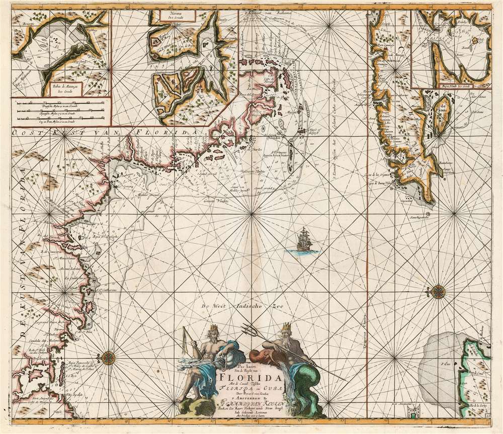
Pas kaart Van de Boght van Florida Met de Canaal Tusschen Florida en Cuba.
1723 (undated) 20.5 x 23.25 in (52.07 x 59.055 cm) 1 : 2770000
1723 (undated) 20.5 x 23.25 in (52.07 x 59.055 cm) 1 : 2770000
Description
This is a striking, original-color example of Gerard van Keulen's thoroughly updated 1723 version of 'the first sea chart of the eastern portion of the Gulf of Mexico detailing the west coast of Florida' (Burden). It is an exceptionally rare chart that appeared late in the van Keulen record, exhibiting meticulous and important revisions unique to this edition.
A Closer Look
The eastward-oriented chart covers the coast of Florida starting from the Perdido River and traces the west coast of Florida, including the Florida Keys. The chart's Floridian cartography continues up the east coast to include Key Biscayne, here marked as Caja de Biscamboa. The Florida coastline depicted here was reworked by the younger Van Keulen, representing a very different chart than that produced by his father in 1684. The chart also includes the northeast corner of the Yucatan Peninsula and illustrates Cuba from Matanzas Bay and the Bahia de Cardenas westward. A trio of insets chart the key Cuban harbors of Matanzas Bay, Havana, and Hondo Bay. Most of the place names are given in Spanish and may have been informed by unpublished Spanish manuscripts.Passing the (Sea) Torch
The earlier editions of this chart were the work of Johannes van Keulen and C. J. Vooght, and were heavily influenced by the then-fifty-year-old hydrography of Hessel Gerritz. It was first printed in 1684 in the fourth part of Van Keulen's Zee-Fakkel (Sea Torch). In Johannes' later years, his son Gerard took up the production of the atlas, and with respect to this map, Gerard added significant updates, appearing in the c. 1702 fourth state of the chart. The entire coastline of Florida - from Rio Perdido around to Key Biscayne - has been completely reworked. Indeed, the original version illustrates neither Rio Perdido nor Pensacola Bay. A town is indicated in the vicinity of modern-day Tampa Bay. The Florida Keys are far more detailed, and the whole is marked with depth soundings. Although the coastlines of Cuba and the Yucatan were unchanged, the interior has been given decorative detail in the form of trees and hills, also added elsewhere in the chart. Gerard also added the track of the Spanish Galleon fleets leaving Havana for Europe via the strait between Cuba and Florida.An Allegorical Cartouche
As with many of Van Keulen's charts, this one is embellished with a beautifully engraved cartouche. It is flanked by two divine figures. To the right is Neptune, armed with a trident and a water-flowing cornucopia. The figure on the left, with his bag of winds, is Aeolius, the god of the winds. He is armed as well, with a three-headed lash. As the lash speeds the horse, so the winds speed the sailor.Publication History and Census
This chart was first engraved for the fourth volume of Johannes van Keulen's 1684 Zee-Fakkel. Around 1702, the plate was significantly altered and improved by Gerard van Keulen. A further amendment of the cartouche (dated 1734 by Burden) adds Gerard's imprint, replacing the elder Van Keulen's name and that of Vooght. The present example conforms to the rare fifth state, as per Burden. We see a single separate example of this state of the chart cataloged in the Biblioteca Nacional de España, but with a date of 1723. Earlier states of this chart, particularly the third, are on the market with some regularity. This state, however, is very rare.CartographerS
Johannes Van Keulen (1654 – 1715) was a Dutch cartographer active in Amsterdam during the late 17th century. Van Keulen was the son of Lucas van Keulen. Van Keulen's firm, ‘In de Gekroonde Lootsman' (In the Crowned Pilot), was founded in 1678 and registered with the Amsterdam bookseller's guild as 'Cross staff-maker and bookseller.' (The cross-staff is a nautical instrument used to determine latitude.) Two years later, in 1680, they obtained a patent from the States General of Holland and West Friesland to publish nautical charts and atlases. Together with his partner, the cartographer Claes Janz Vooght, Van Keulen published numerous atlases and nautical charts, including the Zee Atlas and Nieuwe Lichtende Zee-Fakkel. It was a massive five-volume atlas containing more than 130 nautical charts. The Zee-Fakkel established the Van Keulen firm as the pre-eminent maker of Dutch sea charts in the late 17th and early 18th century. In 1714, one year before Johannes Van Keulen's death, his son, Gerard van Keulen (1678 - 1726), took charge. Gerard continued to update and republish the Zee-Fakkel until his own death in 1726. The firm was later passed on to Gerard's son, Johannes II Van Keulen (1704 - 1755), who significantly updated the atlas, especially with regard to Asia, issuing the 1753 4th Volume, known as the 'Secret Atlas'. The final editions of the atlas were published by Gerard Hulst van Keulen (1733 - 1801), Joannes II's son. The final true Van Keulen edition of the Zee-Fakkel was published posthumously in 1803. It is noteworthy that though ostensibly controlled by the Van Keulen men, it was the Van Keulen widows who maintained and managed the firm in the periods following their husbands' deaths. After the death of Gerard Hulst Van Keulen's son, Johannes Hulst Van Keulen, ownership of the family plates and business fell into the hands of the Swart family, who continued to publish until the company closed its doors 1885, ending a cartographic legacy spanning nearly 207 years. More by this mapmaker...
Gerard van Keulen (1678 - 1726) was a Dutch map publisher and engraver active in Amsterdam during the late 17th and early 18th centuries. Gerard was the son of the more famous Johannes Van Keulen (1654 – 1715) and eventually took over his father's business. He also negotiated to take over the Privilege of Willem Blaeu, thus becoming the official cartographer of the Dutch East India Company (VOC). He was married to Ludowina Konst (16??? - 1740). Gerard is credited with nearly 500 charts and maps published between 1706 and his death in 1726. He also continued to update and republish his family's legendary Zee-Fakkel, often described as the 'Secret Atlas' as it was restricted to VOC pilots. After his death, the firm was passed on to Gerard's son, Johannes II Van Keulen (1704 - 1755), who significantly updated the atlas. The final true Van Keulen editions of the atlas were published by Gerard Hulst Van Keulen (1733 - 1801), Johannes II's son. The final edition of the Zee-Fakkel was published posthumously in 1803. Afterward, the firm fell into the hands of the Swart family, who managed it for several generations until it finally closed its doors in 1885. It is noteworthy that though ostensibly controlled by the Van Keulen men, it was their widows who maintained and managed the firm in the periods following their husbands' deaths. Learn More...
Claes Jansz Vooght (1638 – 1696) was a Dutch astronomer, mathematician, teacher, surveyor and cartographer active in Amsterdam during the 17th century. Vooght described himself as a 'surveyor and teacher of mathematics and the art of navigation' and published extensively on these subjects. His is known to have been a surveyor for the Council of Holland and co-authored several books with Rembrantsz Dirck van Nierop. Though little is known of Vooght's life, his most important cartographic work appeared in conjunction with the prominent Johannes Van Keulen firm, with whom he partnered in 1680. Vooght was responsible for creating and compiling most of the maps in Van Keulen's seminal Nieuwe Lichtende Zee-Fakkel, with many early editions bearing only his name. Learn More...
Hessel Gerritsz (1581 – September 4, 1632) was a Dutch engraver, cartographer, and publisher active in Amsterdam during the late 16th and early 17th centuries, among the most preeminent Dutch geographers of the 17th century. He was born in Assum, a town in northern Holland in 1581. As a young man he relocated to Alkmaar to accept an apprenticeship with Willem Jansz Blaeu (1571-1638). He followed Blaeu to Amsterdam shortly afterwards. By 1610 he has his own press, but remained close to Blaeu, who published many of his maps. In October of 1617 he was appointed the first official cartographer of the Vereenigde Oost-Indische Compagnie (Dutch East Indian Company) or VOC. This strategic position offered him unprecedented access to the most advanced and far-reaching cartographic data of the Dutch Golden Age. Unlike many cartographers of his period, Gerritsz was more than a simple scholar and showed a true fascination with the world and eagerness to learn more of the world he was mapping in a practical manner. In 1628 he joined a voyage to the New World which resulted in the production of his seminal maps, published by Joannes de Laet in his 1630 Beschrijvinghe van West-Indien; these would be aggressively copied by both the Blaeu and Hondius houses, and long represented the standard followed in the mapping of the new world. Among his other prominent works are a world map of 1612, a 1613 map of Russia by the brilliant Russian prince Fyodor II Borisovich Godunov (1589 – 1605), a 1618 map of the pacific that includes the first mapping of Australia, and an influential 1630 map of Florida. Gerritsz died in 1632. His position with the VOC, along with many of his printing plates, were taken over by Willem Janszoon Blaeu. Learn More...
Source
Keulen, G. Van, De nieuwe groote lichtende zee-fakkel, (Amsterdam: Van Keulen) 1723.
Nieuwe Lichtende Zee-Fakkel was the premier Dutch nautical atlas of the late 17th and 18th century. First introduced in 1681, over the course of its more than 100 years in production, the Zee-Fakkel expanded to six volumes. The first five volumes were published in Amsterdam by Johannes van Keulen (1654 - 1715). His son, Gerard van Keulen (1678 - 1726), reissued it in several editions with minor updates.
Grandson, Johannes II van Keulen (1704 - 1755) expanded the atlas in 1753 with Volume VI, illustrating Asian waters. This was a revolutionary addition. For three generations the Van Keulen's were the official cartographers of the VOC (Vereenigde Oostindische Compagnie / United Dutch East India Company). Until 1753, to protect their long-standing trade monopoly, the VOC jealously guarded their hydrographic data on East Asian waters, refusing the allow charts to be printed and requiring oaths of secrecy from the Van Keulens (and Bleaus before them). This led to dangerously inaccurate often contradictory charts. Thus, in 1744 Jan Harmenszoon de Marre (1696 - 1763), the VOC's Amsterdam Examiner, was instructed to work with van Keulen to publish compile, compare, and resolve the VOC's hoard of jealously guarded manuscript charts of East Asian waters. Johannes II and de Marre published the sixth volume of the Zee-Fakkel, focusing on Asian waters - if only for internal VOC use.
This was likely an attempt to consolidate and improve the general hydrography. Previously, VOC charts in manuscript were disseminated to ship captains on an as-needed basis, to be returned upon a voyage's completion. They were rarely compared or amended. A study of several VOC manuscript charts issued between 1720 and 1760 reveal striking disparities, likely resulting either from the charts being updated or copied from earlier less accurate charts. Such led to avoidable navigational and thus trade risks. A printed nautical atlas, whose hydrography was built upon the most recent and up-to-date charts, reassessed by the greatest chartmaker of the age, was a natural solution.
The new atlas, ostensibly an extension (Volume VI) of the existing commercially issued Nieuwe Lichtende Zee-Fakkel, was intended only for VOC use, and so became known as the 'Secret Atlas'. The printing run was extremely small, and access tightly controlled. VOC ship captains navigating to the Far East were given a copy on departure and expected to return it in good condition on return. Even so, the maps of the 'Secret Atlas' were disseminated, perhaps by the van Keulen's themselves. We note evidence of 'secret' Dutch hydrography in charts of the English Pilot as well as in other Dutch charts. Nonetheless, original maps from 'Secret' Zee-Fakkel volume VI remain of the utmost rarity.The firm passed to great-grandson Gerard Hulst van Keulen (1733 - 1801) under whose imprint the final 1803 van Keulen edition was published posthumously.
Grandson, Johannes II van Keulen (1704 - 1755) expanded the atlas in 1753 with Volume VI, illustrating Asian waters. This was a revolutionary addition. For three generations the Van Keulen's were the official cartographers of the VOC (Vereenigde Oostindische Compagnie / United Dutch East India Company). Until 1753, to protect their long-standing trade monopoly, the VOC jealously guarded their hydrographic data on East Asian waters, refusing the allow charts to be printed and requiring oaths of secrecy from the Van Keulens (and Bleaus before them). This led to dangerously inaccurate often contradictory charts. Thus, in 1744 Jan Harmenszoon de Marre (1696 - 1763), the VOC's Amsterdam Examiner, was instructed to work with van Keulen to publish compile, compare, and resolve the VOC's hoard of jealously guarded manuscript charts of East Asian waters. Johannes II and de Marre published the sixth volume of the Zee-Fakkel, focusing on Asian waters - if only for internal VOC use.
This was likely an attempt to consolidate and improve the general hydrography. Previously, VOC charts in manuscript were disseminated to ship captains on an as-needed basis, to be returned upon a voyage's completion. They were rarely compared or amended. A study of several VOC manuscript charts issued between 1720 and 1760 reveal striking disparities, likely resulting either from the charts being updated or copied from earlier less accurate charts. Such led to avoidable navigational and thus trade risks. A printed nautical atlas, whose hydrography was built upon the most recent and up-to-date charts, reassessed by the greatest chartmaker of the age, was a natural solution.
The new atlas, ostensibly an extension (Volume VI) of the existing commercially issued Nieuwe Lichtende Zee-Fakkel, was intended only for VOC use, and so became known as the 'Secret Atlas'. The printing run was extremely small, and access tightly controlled. VOC ship captains navigating to the Far East were given a copy on departure and expected to return it in good condition on return. Even so, the maps of the 'Secret Atlas' were disseminated, perhaps by the van Keulen's themselves. We note evidence of 'secret' Dutch hydrography in charts of the English Pilot as well as in other Dutch charts. Nonetheless, original maps from 'Secret' Zee-Fakkel volume VI remain of the utmost rarity.
Condition
Very good. Few marginal mends; one mend into border with no loss. Light toning at centerfold. Original hand color.
References
OCLC 431781799. Burden, P., The Mapping of North America, 591, state 5.